
Station Z9 E07 - Gowen Timber N, Folkston, GA
Network: Z910 - Southeastern Suture of the Appalachian Margin Experiment
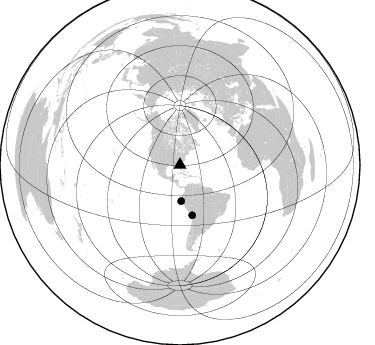
Nearby stations (2 deg radius)
| Station | Name | (Lat, Lon) | Start / End | Elevation |
| E07 | Gowen Timber N, Folkston, GA | (30.72, -82.10) | 2012-05-16 / 2014-05-16 | 34 m |
| Crust2 Type: | DG,thin Platform 1 km seds. |
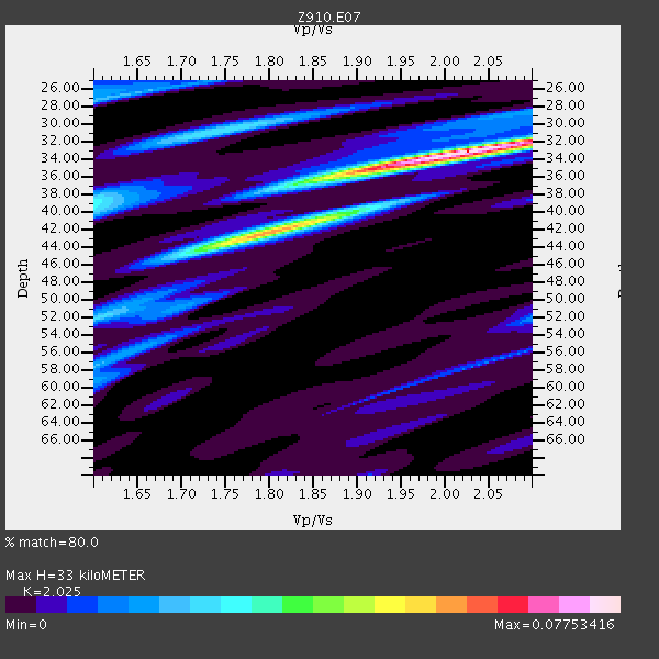
| Thickness Estimate: | 33 km |
| Thickness StdDev: | 3.8 km |
| Vp/Vs Estimate: | 2.03 |
| Vp/Vs StdDev: | 0.09 |
| Vs Estimate: | 3.242 km/s |
| Poisson's Ratio: | 0.34 |
| Peak Value: | 0.08 |
| Assumed Vp: | 6.565 km/s |
| Ps Weight: | 0.33333334 |
| PpPs Weight: | 0.33333334 |
| PsPs Weight: | 0.33333328 |
| Residual Complexity: | 0.574 |
| Nearby stations H: | +- |
| (2.0 deg) Vp/Vs: | +- |
1 with match > 90% ( 14.285714 %) and 2 with match > 80% ( 28.571428 %) out of 7.
Download stack as xyz text file.
Azimuth Distribution of Events:
Prior Results for this Station
| Study | Thickness | Vp/Vs | Vp | Vs | Poissons Ratio | Extra |
| EARS | 33 km | 2.03 | 6.565 km/s | 3.242 km/s | 0.34 | |
| Crust2.0 | 31 km | 1.78 | 6.565 km/s | 3.684 km/s | 0.27 | DG,thin Platform 1 km seds. |
| Global Maxima | 33 km | 2.03 | 6.565 km/s | 3.242 km/s | 0.34 | amp=0.07753416 |
| Local Maxima 1 | 43 km | 1.78 | 6.565 km/s | 3.693 km/s | 0.27 | amp=0.043979164 |
| Local Maxima 2 | 31 km | 1.74 | 6.565 km/s | 3.778 km/s | 0.25 | amp=0.027085492 |
| Local Maxima 3 | 36 km | 1.87 | 6.565 km/s | 3.52 km/s | 0.30 | amp=0.02599876 |
| Local Maxima 4 | 27 km | 1.61 | 6.565 km/s | 4.084 km/s | 0.18 | amp=0.023242107 |
| Predicted Arrivals for vertical incidence (zero ray parameter) | |
| Ps | 5.15 SECOND |
| PpPs | 15.21 SECOND |
| PsPs/PpSs | 20.36 SECOND |
Events Processed for this Station
Download zip of receiver functions as SAC
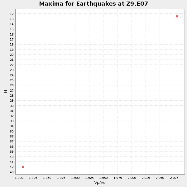
Plot maxima for each earthquake.
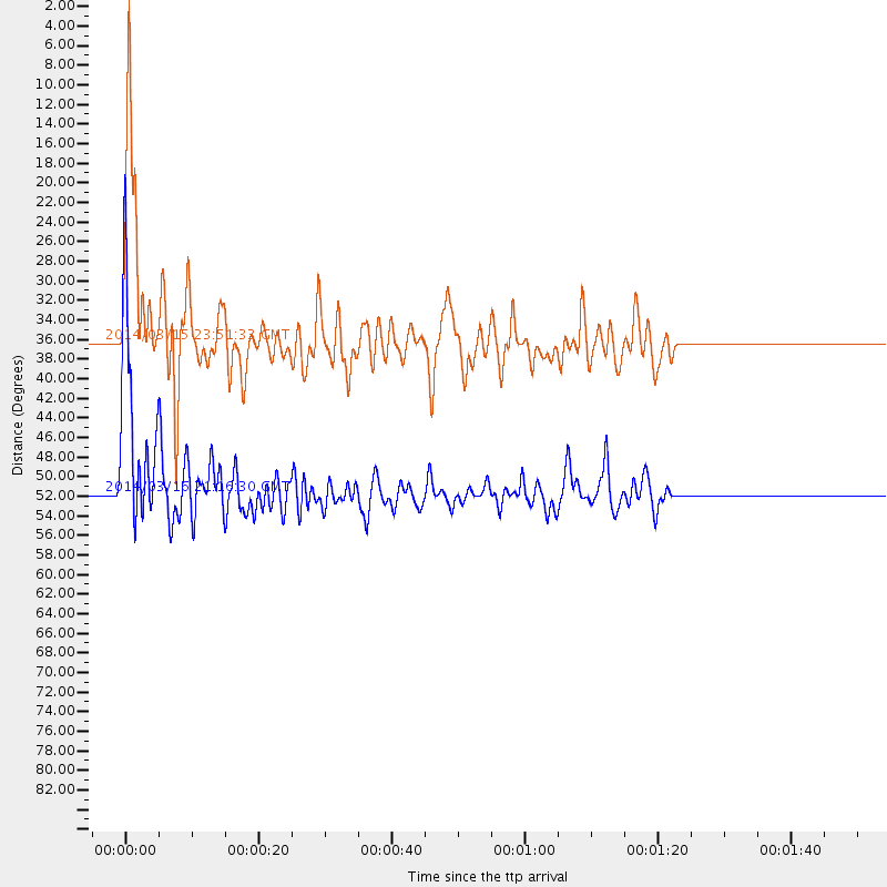
Events Used in the Stack
(2 events)| Radial Match | Distance | Baz | FERegion | Time | Lat/Lon | Depth | Magnitude |
| 92.39249 | 51.5 deg | 166.177 deg | Near Coast Of Northern Chile | 2014/03/16 21:16:30 GMT | (-19.9, -70.6) | 20 km | 6.7 MWW, 6.7 MWC, 7.0 MI |
| 82.422905 | 36.1 deg | 178.072 deg | Near Coast Of Northern Peru | 2014/03/15 23:51:33 GMT | (-5.6, -81.0) | 29 km | 6.3 MWW, 6.2 MWB, 6.3 MWC |
Losers
(5 events)| Radial Match | Distance | Baz | FERegion | Time | Lat/Lon | Depth | Magnitude | Reason |
| 93.11058 | 36.0 deg | 298.31 deg | Off Coast Of Northern California | 2014/03/10 05:18:13 GMT | (40.8, -125.1) | 17 km | 6.8 MW, 6.8 MWR, 6.9 MWW, 6.9 MWB, 7.0 MI, 7.0 MWC | |
| 73.03304 | 44.9 deg | 172.031 deg | Near Coast Of Peru | 2014/03/15 08:59:21 GMT | (-14.1, -76.3) | 20 km | 6.1 MWW, 6.0 MWB, 6.2 MWC | |
| 63.604485 | 45.1 deg | 171.081 deg | Near Coast Of Peru | 2014/02/18 23:35:58 GMT | (-14.2, -75.6) | 57 km | 6.0 MWB, 5.9 MWW, 5.9 MWC, 6.0 MWC | |
| 59.88945 | 86.7 deg | 326.15 deg | Kuril Islands | 2014/01/10 18:03:00 GMT | (48.2, 154.1) | 82 km | 5.1 MW | |
| 59.711018 | 65.8 deg | 319.188 deg | Fox Islands, Aleutian Islands | 2014/02/26 21:13:40 GMT | (53.6, -171.8) | 265 km | 6.1 MWW, 5.9 MI, 5.9 ML, 6.1 MWC, 6.1 MWB, 6.2 MWC |

