
Station Z9 E10 - Varn Timber Company, Hoboken, GA
Network: Z910 - Southeastern Suture of the Appalachian Margin Experiment
Nearby stations (2 deg radius)
| Station | Name | (Lat, Lon) | Start / End | Elevation |
| E10 | Varn Timber Company, Hoboken, GA | (31.07, -82.10) | 2012-05-10 / 2014-05-16 | 36 m |
| Crust2 Type: | DG,thin Platform 1 km seds. |
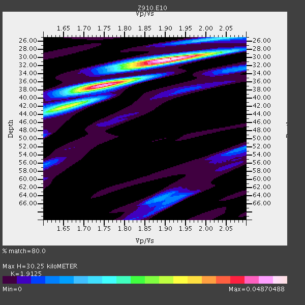
| Thickness Estimate: | 30 km |
| Thickness StdDev: | 3.2 km |
| Vp/Vs Estimate: | 1.91 |
| Vp/Vs StdDev: | 0.08 |
| Vs Estimate: | 3.432 km/s |
| Poisson's Ratio: | 0.31 |
| Peak Value: | 0.05 |
| Assumed Vp: | 6.565 km/s |
| Ps Weight: | 0.33333334 |
| PpPs Weight: | 0.33333334 |
| PsPs Weight: | 0.33333328 |
| Residual Complexity: | 0.560 |
| Nearby stations H: | +- |
| (2.0 deg) Vp/Vs: | +- |
2 with match > 90% ( 7.6923075 %) and 7 with match > 80% ( 26.923077 %) out of 26.
Download stack as xyz text file.
Azimuth Distribution of Events:

Prior Results for this Station
| Study | Thickness | Vp/Vs | Vp | Vs | Poissons Ratio | Extra |
| EARS | 30 km | 1.91 | 6.565 km/s | 3.432 km/s | 0.31 | |
| Crust2.0 | 31 km | 1.78 | 6.565 km/s | 3.684 km/s | 0.27 | DG,thin Platform 1 km seds. |
| Global Maxima | 30 km | 1.91 | 6.565 km/s | 3.432 km/s | 0.31 | amp=0.04870488 |
| Local Maxima 1 | 37 km | 1.74 | 6.565 km/s | 3.784 km/s | 0.25 | amp=0.036399506 |
| Local Maxima 2 | 42 km | 1.65 | 6.565 km/s | 3.972 km/s | 0.21 | amp=0.023419324 |
| Local Maxima 3 | 64 km | 1.89 | 6.565 km/s | 3.478 km/s | 0.30 | amp=0.010777149 |
| Local Maxima 4 | 52 km | 2.10 | 6.565 km/s | 3.13 km/s | 0.35 | amp=0.008688114 |
| Predicted Arrivals for vertical incidence (zero ray parameter) | |
| Ps | 4.20 SECOND |
| PpPs | 13.42 SECOND |
| PsPs/PpSs | 17.63 SECOND |
Events Processed for this Station
Download zip of receiver functions as SAC
Plot maxima for each earthquake.
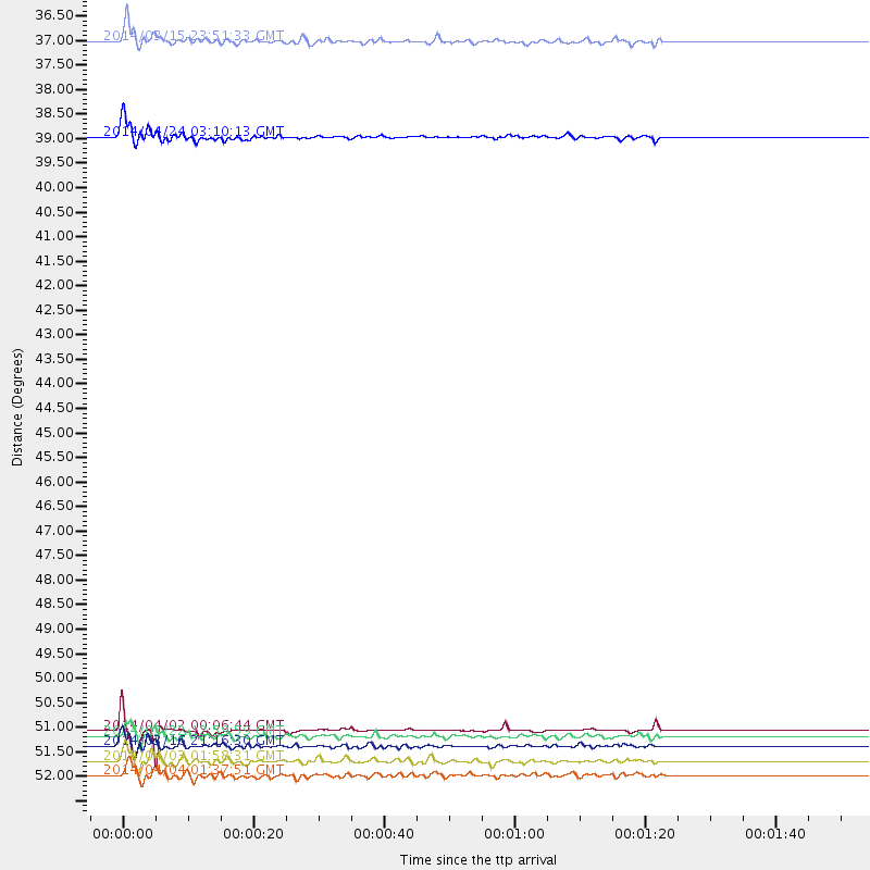
Events Used in the Stack
(7 events)| Radial Match | Distance | Baz | FERegion | Time | Lat/Lon | Depth | Magnitude |
| 91.21482 | 52.2 deg | 166.249 deg | Near Coast Of Northern Chile | 2014/04/03 01:58:31 GMT | (-20.3, -70.6) | 23 km | 6.5 MWW, 6.5 MWB, 6.6 MWC |
| 90.65165 | 38.6 deg | 312.398 deg | Vancouver Island, Canada Region | 2014/04/24 03:10:13 GMT | (49.8, -127.4) | 11 km | 6.7 MWP, 6.7 MI |
| 89.5355 | 51.6 deg | 166.369 deg | Near Coast Of Northern Chile | 2014/04/02 00:06:44 GMT | (-19.6, -70.8) | 10 km | 5.7 MB |
| 87.56272 | 51.7 deg | 166.483 deg | Near Coast Of Northern Chile | 2014/03/22 12:59:59 GMT | (-19.8, -70.9) | 20 km | 6.2 MWW, 6.2 MWB, 6.3 MWC, 6.4 MWC |
| 87.54531 | 52.5 deg | 166.557 deg | Near Coast Of Northern Chile | 2014/04/04 01:37:51 GMT | (-20.6, -70.7) | 20 km | 6.1 MWP, 6.1 MWB, 6.1 MWW, 6.3 MWC |
| 86.70859 | 51.9 deg | 166.239 deg | Near Coast Of Northern Chile | 2014/03/16 21:16:30 GMT | (-19.9, -70.6) | 20 km | 6.7 MWW, 6.7 MWC, 7.0 MI |
| 86.588554 | 36.5 deg | 178.082 deg | Near Coast Of Northern Peru | 2014/03/15 23:51:33 GMT | (-5.6, -81.0) | 29 km | 6.3 MWW, 6.2 MWB, 6.3 MWC |
Losers
(19 events)| Radial Match | Distance | Baz | FERegion | Time | Lat/Lon | Depth | Magnitude | Reason |
| 97.24486 | 51.6 deg | 166.383 deg | Near Coast Of Northern Chile | 2014/04/01 23:46:46 GMT | (-19.6, -70.8) | 20 km | 8.2 MWW, 8.0 MI, 8.1 MWC | |
| 95.35053 | 52.5 deg | 166.25 deg | Near Coast Of Northern Chile | 2014/04/03 02:43:14 GMT | (-20.5, -70.5) | 31 km | 7.7 MWW, 7.4 MI, 7.7 MWC | |
| 92.059456 | 35.9 deg | 297.887 deg | Off Coast Of Northern California | 2014/03/10 05:18:13 GMT | (40.8, -125.1) | 17 km | 6.8 MW, 6.8 MWR, 6.9 MWW, 6.9 MWB, 7.0 MI, 7.0 MWC | |
| 75.620445 | 52.8 deg | 166.387 deg | Near Coast Of Northern Chile | 2014/04/03 05:26:16 GMT | (-20.8, -70.5) | 24 km | 6.2 MWP, 6.2 MWR, 6.3 MWW, 6.5 MWC | |
| 71.020935 | 52.1 deg | 166.561 deg | Near Coast Of Northern Chile | 2014/04/02 04:46:18 GMT | (-20.2, -70.9) | 10 km | 5.8 MB | |
| 67.31227 | 57.9 deg | 333.58 deg | Northern Alaska | 2014/05/03 08:57:12 GMT | (67.6, -162.2) | 0.9 km | 5.5 MB | |
| 66.606155 | 45.2 deg | 172.074 deg | Near Coast Of Peru | 2014/03/15 08:59:21 GMT | (-14.1, -76.3) | 20 km | 6.1 MWW, 6.0 MWB, 6.2 MWC | |
| 61.60811 | 45.4 deg | 171.129 deg | Near Coast Of Peru | 2014/02/18 23:35:58 GMT | (-14.2, -75.6) | 57 km | 6.0 MWB, 5.9 MWW, 5.9 MWC, 6.0 MWC | |
| 61.42181 | 53.8 deg | 324.162 deg | Southern Alaska | 2014/05/10 14:16:08 GMT | (60.0, -152.2) | 96 km | 5.8 ML, 5.5 MI, 5.7 MWP | |
| 57.166965 | 51.5 deg | 166.503 deg | Near Coast Of Northern Chile | 2014/04/02 01:20:59 GMT | (-19.6, -70.9) | 22 km | 5.2 mb | |
| 56.11152 | 51.7 deg | 166.403 deg | Near Coast Of Northern Chile | 2014/03/23 18:20:03 GMT | (-19.7, -70.8) | 35 km | 6.0 MB, 6.2 MWB, 6.2 MWW, 6.3 MWC | |
| 55.888515 | 65.5 deg | 319.084 deg | Fox Islands, Aleutian Islands | 2014/02/26 21:13:40 GMT | (53.6, -171.8) | 265 km | 6.1 MWW, 5.9 MI, 5.9 ML, 6.1 MWC, 6.1 MWB, 6.2 MWC | |
| 55.61208 | 53.0 deg | 158.339 deg | Southern Bolivia | 2014/01/27 16:42:37 GMT | (-19.3, -63.9) | 600 km | 5.6 MWB | |
| 53.14797 | 68.4 deg | 192.641 deg | West Chile Rise | 2014/05/06 20:52:29 GMT | (-36.3, -96.7) | 14 km | 5.9 MWB | |
| 51.591087 | 68.2 deg | 50.368 deg | France | 2014/04/07 19:27:00 GMT | (44.5, 6.7) | 9.1 km | 5.0 MW | |
| 46.112797 | 64.3 deg | 170.173 deg | Near Coast Of Central Chile | 2014/04/05 02:22:38 GMT | (-32.8, -71.6) | 40 km | 5.6 MWC, 5.6 MWC | |
| 44.91445 | 65.2 deg | 107.163 deg | Central Mid-Atlantic Ridge | 2014/03/29 07:46:50 GMT | (-0.8, -21.9) | 12 km | 5.9 MWW, 5.8 MWB, 6.0 MWC | |
| 42.11185 | 91.9 deg | 326.402 deg | Kuril Islands | 2014/05/05 14:38:25 GMT | (44.4, 148.4) | 82 km | 4.2 mb | |
| 36.4493 | 80.2 deg | 51.339 deg | Greece | 2014/02/03 03:16:14 GMT | (38.2, 20.3) | 13 km | 4.1 mb |

