
Station Z9 E13 - Lee Property, Hoboken, GA
Network: Z910 - Southeastern Suture of the Appalachian Margin Experiment
Nearby stations (2 deg radius)
| Station | Name | (Lat, Lon) | Start / End | Elevation |
| E13 | Lee Property, Hoboken, GA | (31.22, -82.09) | 2012-05-10 / 2014-05-16 | 44 m |
| Crust2 Type: | DG,thin Platform 1 km seds. |
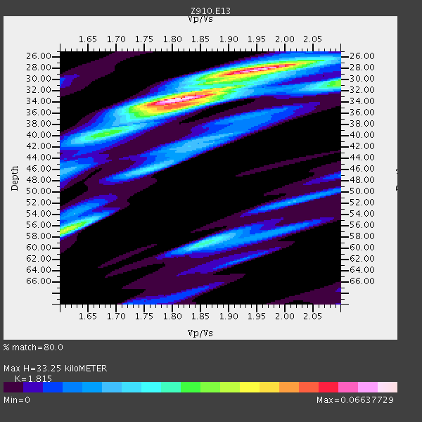
| Thickness Estimate: | 33 km |
| Thickness StdDev: | 2.8 km |
| Vp/Vs Estimate: | 1.82 |
| Vp/Vs StdDev: | 0.07 |
| Vs Estimate: | 3.617 km/s |
| Poisson's Ratio: | 0.28 |
| Peak Value: | 0.07 |
| Assumed Vp: | 6.565 km/s |
| Ps Weight: | 0.33333334 |
| PpPs Weight: | 0.33333334 |
| PsPs Weight: | 0.33333328 |
| Residual Complexity: | 0.644 |
| Nearby stations H: | +- |
| (2.0 deg) Vp/Vs: | +- |
2 with match > 90% ( 8.0 %) and 5 with match > 80% ( 20.0 %) out of 25.
Download stack as xyz text file.
Azimuth Distribution of Events:

Prior Results for this Station
| Study | Thickness | Vp/Vs | Vp | Vs | Poissons Ratio | Extra |
| EARS | 33 km | 1.82 | 6.565 km/s | 3.617 km/s | 0.28 | |
| Crust2.0 | 31 km | 1.78 | 6.565 km/s | 3.684 km/s | 0.27 | DG,thin Platform 1 km seds. |
| Global Maxima | 33 km | 1.82 | 6.565 km/s | 3.617 km/s | 0.28 | amp=0.06637729 |
| Local Maxima 1 | 28 km | 1.96 | 6.565 km/s | 3.345 km/s | 0.32 | amp=0.05426048 |
| Local Maxima 2 | 57 km | 1.61 | 6.565 km/s | 4.084 km/s | 0.18 | amp=0.039915074 |
| Local Maxima 3 | 59 km | 1.86 | 6.565 km/s | 3.539 km/s | 0.30 | amp=0.028814757 |
| Local Maxima 4 | 36 km | 1.80 | 6.565 km/s | 3.657 km/s | 0.27 | amp=0.024729809 |
| Predicted Arrivals for vertical incidence (zero ray parameter) | |
| Ps | 4.13 SECOND |
| PpPs | 14.26 SECOND |
| PsPs/PpSs | 18.39 SECOND |
Events Processed for this Station
Download zip of receiver functions as SAC
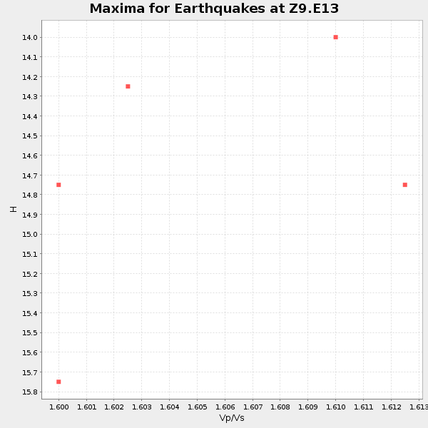
Plot maxima for each earthquake.
Events Used in the Stack
(5 events)| Radial Match | Distance | Baz | FERegion | Time | Lat/Lon | Depth | Magnitude |
| 93.80209 | 52.0 deg | 166.278 deg | Near Coast Of Northern Chile | 2014/03/16 21:16:30 GMT | (-19.9, -70.6) | 20 km | 6.7 MWW, 6.7 MWC, 7.0 MI |
| 93.00882 | 38.5 deg | 312.252 deg | Vancouver Island, Canada Region | 2014/04/24 03:10:13 GMT | (49.8, -127.4) | 11 km | 6.7 MWP, 6.7 MI |
| 89.32685 | 52.4 deg | 166.288 deg | Near Coast Of Northern Chile | 2014/04/03 01:58:31 GMT | (-20.3, -70.6) | 23 km | 6.5 MWW, 6.5 MWB, 6.6 MWC |
| 88.27365 | 51.8 deg | 166.522 deg | Near Coast Of Northern Chile | 2014/03/22 12:59:59 GMT | (-19.8, -70.9) | 20 km | 6.2 MWW, 6.2 MWB, 6.3 MWC, 6.4 MWC |
| 81.85057 | 36.6 deg | 178.105 deg | Near Coast Of Northern Peru | 2014/03/15 23:51:33 GMT | (-5.6, -81.0) | 29 km | 6.3 MWW, 6.2 MWB, 6.3 MWC |
Losers
(20 events)| Radial Match | Distance | Baz | FERegion | Time | Lat/Lon | Depth | Magnitude | Reason |
| 96.51044 | 51.7 deg | 166.423 deg | Near Coast Of Northern Chile | 2014/04/01 23:46:46 GMT | (-19.6, -70.8) | 20 km | 8.2 MWW, 8.0 MI, 8.1 MWC | |
| 95.41236 | 52.6 deg | 166.289 deg | Near Coast Of Northern Chile | 2014/04/03 02:43:14 GMT | (-20.5, -70.5) | 31 km | 7.7 MWW, 7.4 MI, 7.7 MWC | |
| 92.20296 | 35.8 deg | 297.696 deg | Off Coast Of Northern California | 2014/03/10 05:18:13 GMT | (40.8, -125.1) | 17 km | 6.8 MW, 6.8 MWR, 6.9 MWW, 6.9 MWB, 7.0 MI, 7.0 MWC | |
| 79.767525 | 52.9 deg | 166.425 deg | Near Coast Of Northern Chile | 2014/04/03 05:26:16 GMT | (-20.8, -70.5) | 24 km | 6.2 MWP, 6.2 MWR, 6.3 MWW, 6.5 MWC | |
| 78.21863 | 52.7 deg | 166.595 deg | Near Coast Of Northern Chile | 2014/04/04 01:37:51 GMT | (-20.6, -70.7) | 20 km | 6.1 MWP, 6.1 MWB, 6.1 MWW, 6.3 MWC | |
| 72.71555 | 52.1 deg | 166.283 deg | Near Coast Of Northern Chile | 2014/04/02 00:37:49 GMT | (-20.0, -70.6) | 20 km | 5.4 mb | |
| 71.58658 | 45.6 deg | 171.166 deg | Near Coast Of Peru | 2014/02/18 23:35:58 GMT | (-14.2, -75.6) | 57 km | 6.0 MWB, 5.9 MWW, 5.9 MWC, 6.0 MWC | |
| 71.07432 | 51.8 deg | 166.443 deg | Near Coast Of Northern Chile | 2014/03/23 18:20:03 GMT | (-19.7, -70.8) | 35 km | 6.0 MB, 6.2 MWB, 6.2 MWW, 6.3 MWC | |
| 68.6185 | 52.8 deg | 166.611 deg | Near Coast Of Northern Chile | 2014/04/11 00:01:44 GMT | (-20.7, -70.7) | 18 km | 6.0 MB | |
| 65.82903 | 45.4 deg | 172.108 deg | Near Coast Of Peru | 2014/03/15 08:59:21 GMT | (-14.1, -76.3) | 20 km | 6.1 MWW, 6.0 MWB, 6.2 MWC | |
| 55.15774 | 53.1 deg | 158.392 deg | Southern Bolivia | 2014/01/27 16:42:37 GMT | (-19.3, -63.9) | 600 km | 5.6 MWB | |
| 52.305847 | 52.6 deg | 166.541 deg | Near Coast Of Northern Chile | 2014/04/03 09:23:21 GMT | (-20.6, -70.7) | 15 km | 5.6 MB, 5.3 MWR | |
| 49.749104 | 65.0 deg | 170.025 deg | Near Coast Of Central Chile | 2014/03/06 04:37:05 GMT | (-33.3, -71.3) | 59 km | 5.4 MW | |
| 49.363487 | 65.4 deg | 319.04 deg | Fox Islands, Aleutian Islands | 2014/02/26 21:13:40 GMT | (53.6, -171.8) | 265 km | 6.1 MWW, 5.9 MI, 5.9 ML, 6.1 MWC, 6.1 MWB, 6.2 MWC | |
| 46.074566 | 95.1 deg | 205.154 deg | Pacific-Antarctic Ridge | 2014/04/17 13:10:06 GMT | (-55.1, -129.5) | 16 km | 5.5 MB, 5.7 MWC | |
| 45.293808 | 53.7 deg | 324.096 deg | Southern Alaska | 2014/05/10 14:16:08 GMT | (60.0, -152.2) | 96 km | 5.8 ML, 5.5 MI, 5.7 MWP | |
| 44.82394 | 52.0 deg | 166.51 deg | Near Coast Of Northern Chile | 2014/05/05 22:52:23 GMT | (-19.9, -70.8) | 12 km | 4.9 Mww | |
| 44.52756 | 70.5 deg | 318.494 deg | Andreanof Islands, Aleutian Is. | 2014/01/16 07:33:09 GMT | (51.2, -179.2) | 27 km | 5.5 MWB, 5.2 ML, 5.5 ML, 5.6 MWC | |
| 40.380627 | 86.5 deg | 326.697 deg | Kuril Islands | 2014/04/26 13:55:55 GMT | (48.5, 153.3) | 131 km | 5.1 MW | |
| 26.915472 | 56.3 deg | 165.806 deg | Northern Chile | 2014/03/20 18:41:32 GMT | (-24.0, -69.2) | 96 km | 5.1 MW |

