
Station Z9 E18 - Harris Farm, Screven, GA
Network: Z910 - Southeastern Suture of the Appalachian Margin Experiment
Nearby stations (2 deg radius)
| Station | Name | (Lat, Lon) | Start / End | Elevation |
| E18 | Harris Farm, Screven, GA | (31.57, -82.10) | 2012-05-07 / 2014-05-15 | 51 m |
| Crust2 Type: | DG,thin Platform 1 km seds. |
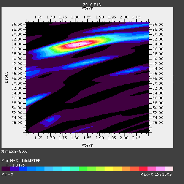
| Thickness Estimate: | 34 km |
| Thickness StdDev: | 0.7 km |
| Vp/Vs Estimate: | 1.82 |
| Vp/Vs StdDev: | 0.02 |
| Vs Estimate: | 3.612 km/s |
| Poisson's Ratio: | 0.28 |
| Peak Value: | 0.15 |
| Assumed Vp: | 6.565 km/s |
| Ps Weight: | 0.33333334 |
| PpPs Weight: | 0.33333334 |
| PsPs Weight: | 0.33333328 |
| Residual Complexity: | 0.446 |
| Nearby stations H: | +- |
| (2.0 deg) Vp/Vs: | +- |
4 with match > 90% ( 15.384615 %) and 5 with match > 80% ( 19.23077 %) out of 26.
Download stack as xyz text file.
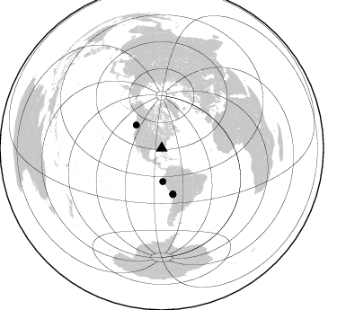
Azimuth Distribution of Events:
Prior Results for this Station
| Study | Thickness | Vp/Vs | Vp | Vs | Poissons Ratio | Extra |
| EARS | 34 km | 1.82 | 6.565 km/s | 3.612 km/s | 0.28 | |
| Crust2.0 | 31 km | 1.78 | 6.565 km/s | 3.684 km/s | 0.27 | DG,thin Platform 1 km seds. |
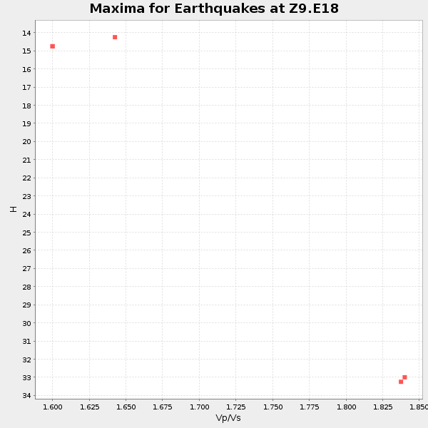
| Global Maxima | 34 km | 1.82 | 6.565 km/s | 3.612 km/s | 0.28 | amp=0.1521609 |
| Local Maxima 1 | 33 km | 1.81 | 6.565 km/s | 3.622 km/s | 0.28 | amp=0.086171776 |
| Local Maxima 2 | 58 km | 1.60 | 6.565 km/s | 4.103 km/s | 0.18 | amp=0.048612464 |
| Local Maxima 3 | 36 km | 1.79 | 6.565 km/s | 3.667 km/s | 0.27 | amp=0.041171566 |
| Local Maxima 4 | 41 km | 1.85 | 6.565 km/s | 3.544 km/s | 0.29 | amp=0.0390296 |
| Predicted Arrivals for vertical incidence (zero ray parameter) | |
| Ps | 4.23 SECOND |
| PpPs | 14.59 SECOND |
| PsPs/PpSs | 18.83 SECOND |
Events Processed for this Station
Download zip of receiver functions as SAC
Plot maxima for each earthquake.
Events Used in the Stack
(5 events)| Radial Match | Distance | Baz | FERegion | Time | Lat/Lon | Depth | Magnitude |
| 94.7996 | 52.4 deg | 166.332 deg | Near Coast Of Northern Chile | 2014/03/16 21:16:30 GMT | (-19.9, -70.6) | 20 km | 6.7 MWW, 6.7 MWC, 7.0 MI |
| 92.55033 | 52.2 deg | 166.575 deg | Near Coast Of Northern Chile | 2014/03/22 12:59:59 GMT | (-19.8, -70.9) | 20 km | 6.2 MWW, 6.2 MWB, 6.3 MWC, 6.4 MWC |
| 92.11717 | 52.7 deg | 166.341 deg | Near Coast Of Northern Chile | 2014/04/03 01:58:31 GMT | (-20.3, -70.6) | 23 km | 6.5 MWW, 6.5 MWB, 6.6 MWC |
| 90.60801 | 38.2 deg | 311.932 deg | Vancouver Island, Canada Region | 2014/04/24 03:10:13 GMT | (49.8, -127.4) | 11 km | 6.7 MWP, 6.7 MI |
| 85.46805 | 37.0 deg | 178.107 deg | Near Coast Of Northern Peru | 2014/03/15 23:51:33 GMT | (-5.6, -81.0) | 29 km | 6.3 MWW, 6.2 MWB, 6.3 MWC |
Losers
(21 events)| Radial Match | Distance | Baz | FERegion | Time | Lat/Lon | Depth | Magnitude | Reason |
| 97.908966 | 52.1 deg | 166.477 deg | Near Coast Of Northern Chile | 2014/04/01 23:46:46 GMT | (-19.6, -70.8) | 20 km | 8.2 MWW, 8.0 MI, 8.1 MWC | |
| 95.29983 | 53.0 deg | 166.342 deg | Near Coast Of Northern Chile | 2014/04/03 02:43:14 GMT | (-20.5, -70.5) | 31 km | 7.7 MWW, 7.4 MI, 7.7 MWC | |
| 88.40868 | 52.0 deg | 166.463 deg | Near Coast Of Northern Chile | 2014/04/02 00:06:44 GMT | (-19.6, -70.8) | 10 km | 5.7 MB | |
| 88.4052 | 35.6 deg | 297.274 deg | Off Coast Of Northern California | 2014/03/10 05:18:13 GMT | (40.8, -125.1) | 17 km | 6.8 MW, 6.8 MWR, 6.9 MWW, 6.9 MWB, 7.0 MI, 7.0 MWC | |
| 88.321106 | 97.2 deg | 335.228 deg | E. Russia-N.E. China Border Reg. | 2014/04/12 21:22:44 GMT | (44.9, 133.7) | 10 km | 4.3 mb | |
| 88.02815 | 53.0 deg | 166.646 deg | Near Coast Of Northern Chile | 2014/04/04 01:37:51 GMT | (-20.6, -70.7) | 20 km | 6.1 MWP, 6.1 MWB, 6.1 MWW, 6.3 MWC | |
| 80.37537 | 45.9 deg | 171.206 deg | Near Coast Of Peru | 2014/02/18 23:35:58 GMT | (-14.2, -75.6) | 57 km | 6.0 MWB, 5.9 MWW, 5.9 MWC, 6.0 MWC | |
| 76.29337 | 52.2 deg | 166.497 deg | Near Coast Of Northern Chile | 2014/03/23 18:20:03 GMT | (-19.7, -70.8) | 35 km | 6.0 MB, 6.2 MWB, 6.2 MWW, 6.3 MWC | |
| 75.87819 | 52.4 deg | 166.337 deg | Near Coast Of Northern Chile | 2014/04/02 00:37:49 GMT | (-20.0, -70.6) | 20 km | 5.4 mb | |
| 72.44366 | 53.0 deg | 166.618 deg | Near Coast Of Northern Chile | 2014/04/03 04:17:57 GMT | (-20.6, -70.7) | 18 km | 5.2 mb | |
| 66.80019 | 45.7 deg | 172.143 deg | Near Coast Of Peru | 2014/03/15 08:59:21 GMT | (-14.1, -76.3) | 20 km | 6.1 MWW, 6.0 MWB, 6.2 MWC | |
| 65.71934 | 65.1 deg | 318.934 deg | Fox Islands, Aleutian Islands | 2014/02/26 21:13:40 GMT | (53.6, -171.8) | 265 km | 6.1 MWW, 5.9 MI, 5.9 ML, 6.1 MWC, 6.1 MWB, 6.2 MWC | |
| 64.8613 | 53.4 deg | 323.947 deg | Southern Alaska | 2014/05/10 14:16:08 GMT | (60.0, -152.2) | 96 km | 5.8 ML, 5.5 MI, 5.7 MWP | |
| 63.38182 | 53.5 deg | 158.477 deg | Southern Bolivia | 2014/01/27 16:42:37 GMT | (-19.3, -63.9) | 600 km | 5.6 MWB | |
| 52.947216 | 77.1 deg | 175.755 deg | Off Coast Of Southern Chile | 2014/03/02 17:03:43 GMT | (-45.8, -76.2) | 10 km | 5.4 MW | |
| 52.517117 | 51.3 deg | 164.456 deg | Northern Chile | 2014/01/29 10:01:50 GMT | (-18.5, -69.4) | 120 km | 5.6 MWW, 5.6 MWB, 5.7 MWC | |
| 49.225666 | 57.5 deg | 333.44 deg | Northern Alaska | 2014/05/03 08:57:12 GMT | (67.6, -162.2) | 0.9 km | 5.5 MB | |
| 46.680244 | 53.0 deg | 166.593 deg | Near Coast Of Northern Chile | 2014/04/03 09:23:21 GMT | (-20.6, -70.7) | 15 km | 5.6 MB, 5.3 MWR | |
| 43.16735 | 84.3 deg | 325.726 deg | Kuril Islands | 2014/01/19 00:52:35 GMT | (49.1, 156.4) | 34 km | 4.9 MW | |
| 41.176548 | 52.9 deg | 166.399 deg | Near Coast Of Northern Chile | 2014/04/02 19:45:49 GMT | (-20.4, -70.6) | 17 km | 5.3 MW | |
| 37.955627 | 52.4 deg | 166.521 deg | Near Coast Of Northern Chile | 2014/03/18 21:26:45 GMT | (-20.0, -70.8) | 3.8 km | 5.8 MWW, 5.9 MWC, 6.0 MWR, 6.0 MWB |

