
Station Z9 E19 - Burch Farm, Screven, GA
Network: Z910 - Southeastern Suture of the Appalachian Margin Experiment
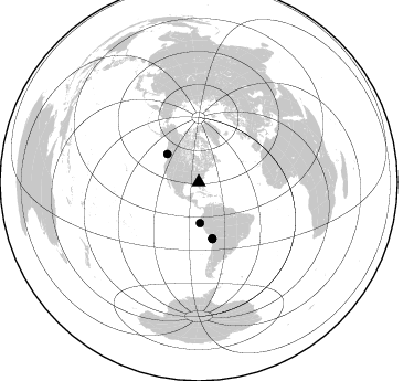
Nearby stations (2 deg radius)
| Station | Name | (Lat, Lon) | Start / End | Elevation |
| E19 | Burch Farm, Screven, GA | (31.62, -82.11) | 2012-05-06 / 2014-05-16 | 48 m |
| Crust2 Type: | DG,thin Platform 1 km seds. |
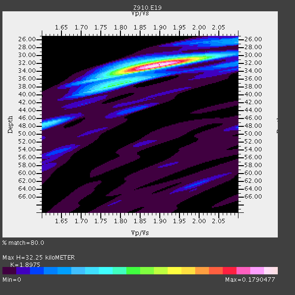
| Thickness Estimate: | 32 km |
| Thickness StdDev: | 1.1 km |
| Vp/Vs Estimate: | 1.90 |
| Vp/Vs StdDev: | 0.03 |
| Vs Estimate: | 3.46 km/s |
| Poisson's Ratio: | 0.31 |
| Peak Value: | 0.18 |
| Assumed Vp: | 6.565 km/s |
| Ps Weight: | 0.33333334 |
| PpPs Weight: | 0.33333334 |
| PsPs Weight: | 0.33333328 |
| Residual Complexity: | 0.323 |
| Nearby stations H: | +- |
| (2.0 deg) Vp/Vs: | +- |
3 with match > 90% ( 11.111111 %) and 5 with match > 80% ( 18.518518 %) out of 27.
Download stack as xyz text file.
Azimuth Distribution of Events:
Prior Results for this Station
| Study | Thickness | Vp/Vs | Vp | Vs | Poissons Ratio | Extra |
| EARS | 32 km | 1.90 | 6.565 km/s | 3.46 km/s | 0.31 | |
| Crust2.0 | 31 km | 1.78 | 6.565 km/s | 3.684 km/s | 0.27 | DG,thin Platform 1 km seds. |
| Global Maxima | 32 km | 1.90 | 6.565 km/s | 3.46 km/s | 0.31 | amp=0.1790477 |
| Local Maxima 1 | 47 km | 1.61 | 6.565 km/s | 4.077 km/s | 0.19 | amp=0.06401208 |
| Local Maxima 2 | 37 km | 1.79 | 6.565 km/s | 3.667 km/s | 0.27 | amp=0.05125687 |
| Local Maxima 3 | 36 km | 1.75 | 6.565 km/s | 3.746 km/s | 0.26 | amp=0.044976685 |
| Local Maxima 4 | 31 km | 1.93 | 6.565 km/s | 3.397 km/s | 0.32 | amp=0.032632347 |
| Predicted Arrivals for vertical incidence (zero ray parameter) | |
| Ps | 4.41 SECOND |
| PpPs | 14.23 SECOND |
| PsPs/PpSs | 18.64 SECOND |
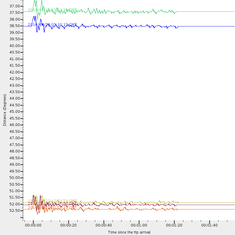
Events Processed for this Station
Download zip of receiver functions as SAC
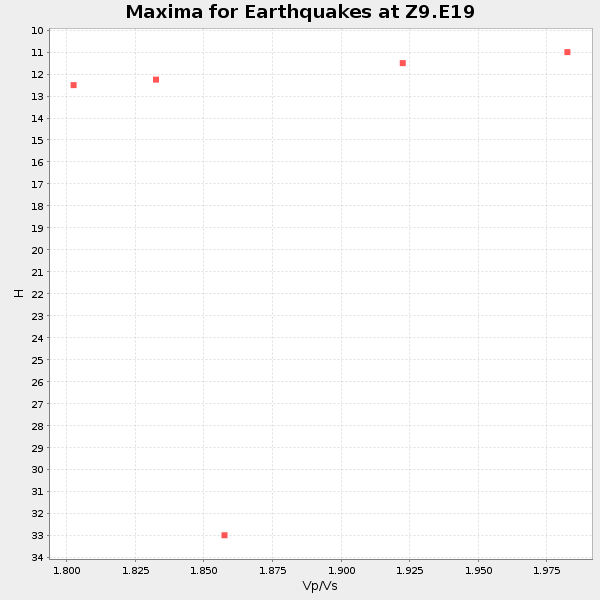
Plot maxima for each earthquake.
Events Used in the Stack
(5 events)| Radial Match | Distance | Baz | FERegion | Time | Lat/Lon | Depth | Magnitude |
| 92.7147 | 52.4 deg | 166.328 deg | Near Coast Of Northern Chile | 2014/03/16 21:16:30 GMT | (-19.9, -70.6) | 20 km | 6.7 MWW, 6.7 MWC, 7.0 MI |
| 90.68899 | 52.8 deg | 166.337 deg | Near Coast Of Northern Chile | 2014/04/03 01:58:31 GMT | (-20.3, -70.6) | 23 km | 6.5 MWW, 6.5 MWB, 6.6 MWC |
| 90.64669 | 38.2 deg | 311.886 deg | Vancouver Island, Canada Region | 2014/04/24 03:10:13 GMT | (49.8, -127.4) | 11 km | 6.7 MWP, 6.7 MI |
| 89.14556 | 52.2 deg | 166.571 deg | Near Coast Of Northern Chile | 2014/03/22 12:59:59 GMT | (-19.8, -70.9) | 20 km | 6.2 MWW, 6.2 MWB, 6.3 MWC, 6.4 MWC |
| 87.47301 | 37.0 deg | 178.09 deg | Near Coast Of Northern Peru | 2014/03/15 23:51:33 GMT | (-5.6, -81.0) | 29 km | 6.3 MWW, 6.2 MWB, 6.3 MWC |
Losers
(22 events)| Radial Match | Distance | Baz | FERegion | Time | Lat/Lon | Depth | Magnitude | Reason |
| 97.20545 | 52.1 deg | 166.473 deg | Near Coast Of Northern Chile | 2014/04/01 23:46:46 GMT | (-19.6, -70.8) | 20 km | 8.2 MWW, 8.0 MI, 8.1 MWC | |
| 94.87005 | 53.0 deg | 166.338 deg | Near Coast Of Northern Chile | 2014/04/03 02:43:14 GMT | (-20.5, -70.5) | 31 km | 7.7 MWW, 7.4 MI, 7.7 MWC | |
| 87.439835 | 35.6 deg | 297.211 deg | Off Coast Of Northern California | 2014/03/10 05:18:13 GMT | (40.8, -125.1) | 17 km | 6.8 MW, 6.8 MWR, 6.9 MWW, 6.9 MWB, 7.0 MI, 7.0 MWC | |
| 87.41702 | 53.1 deg | 166.642 deg | Near Coast Of Northern Chile | 2014/04/04 01:37:51 GMT | (-20.6, -70.7) | 20 km | 6.1 MWP, 6.1 MWB, 6.1 MWW, 6.3 MWC | |
| 86.35596 | 52.1 deg | 166.459 deg | Near Coast Of Northern Chile | 2014/04/02 00:06:44 GMT | (-19.6, -70.8) | 10 km | 5.7 MB | |
| 78.36769 | 45.9 deg | 171.198 deg | Near Coast Of Peru | 2014/02/18 23:35:58 GMT | (-14.2, -75.6) | 57 km | 6.0 MWB, 5.9 MWW, 5.9 MWC, 6.0 MWC | |
| 62.77567 | 45.8 deg | 172.134 deg | Near Coast Of Peru | 2014/03/15 08:59:21 GMT | (-14.1, -76.3) | 20 km | 6.1 MWW, 6.0 MWB, 6.2 MWC | |
| 61.474957 | 53.3 deg | 323.924 deg | Southern Alaska | 2014/05/10 14:16:08 GMT | (60.0, -152.2) | 96 km | 5.8 ML, 5.5 MI, 5.7 MWP | |
| 61.277515 | 51.8 deg | 166.325 deg | Near Coast Of Northern Chile | 2014/04/02 02:52:26 GMT | (-19.3, -70.8) | 17 km | 4.9 mb | |
| 59.73018 | 64.8 deg | 170.208 deg | Near Coast Of Central Chile | 2014/04/05 02:22:38 GMT | (-32.8, -71.6) | 40 km | 5.6 MWC, 5.6 MWC | |
| 54.014187 | 57.4 deg | 333.425 deg | Northern Alaska | 2014/05/03 08:57:12 GMT | (67.6, -162.2) | 0.9 km | 5.5 MB | |
| 53.660976 | 72.5 deg | 102.627 deg | North Of Ascension Island | 2014/04/30 15:52:42 GMT | (-1.2, -13.5) | 14 km | 5.8 MW | |
| 52.89896 | 53.0 deg | 166.588 deg | Near Coast Of Northern Chile | 2014/04/03 09:23:21 GMT | (-20.6, -70.7) | 15 km | 5.6 MB, 5.3 MWR | |
| 50.825813 | 79.1 deg | 114.086 deg | Southern Mid-Atlantic Ridge | 2014/02/20 04:09:57 GMT | (-14.1, -14.6) | 14 km | 5.1 MW | |
| 49.678066 | 51.7 deg | 166.583 deg | Near Coast Of Northern Chile | 2014/05/05 09:02:55 GMT | (-19.3, -71.0) | 21 km | 4.9 MW | |
| 46.825527 | 92.9 deg | 330.492 deg | Hokkaido, Japan Region | 2014/02/20 23:12:38 GMT | (45.9, 142.6) | 324 km | 5.2 MW | |
| 44.990227 | 37.0 deg | 298.981 deg | Off Coast Of Northern California | 2014/03/13 19:11:34 GMT | (41.9, -126.9) | 10 km | 5.5 MWW, 4.0 ML, 5.5 MWC, 5.6 MI | |
| 44.12792 | 56.7 deg | 165.849 deg | Northern Chile | 2014/03/20 18:41:32 GMT | (-24.0, -69.2) | 96 km | 5.1 MW | |
| 44.10989 | 53.7 deg | 165.59 deg | Northern Chile | 2014/01/07 03:43:23 GMT | (-21.0, -69.7) | 87 km | 5.4 MW | |
| 43.98032 | 68.9 deg | 192.586 deg | West Chile Rise | 2014/05/06 20:52:29 GMT | (-36.3, -96.7) | 14 km | 5.9 MWB | |
| 43.407326 | 65.1 deg | 318.916 deg | Fox Islands, Aleutian Islands | 2014/02/26 21:13:40 GMT | (53.6, -171.8) | 265 km | 6.1 MWW, 5.9 MI, 5.9 ML, 6.1 MWC, 6.1 MWB, 6.2 MWC | |
| 42.454735 | 53.5 deg | 158.478 deg | Southern Bolivia | 2014/01/27 16:42:37 GMT | (-19.3, -63.9) | 600 km | 5.6 MWB |

