
Station Z9 E20 - Carter Farm, Odum, GA
Network: Z910 - Southeastern Suture of the Appalachian Margin Experiment
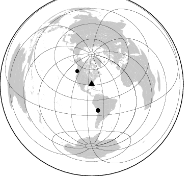
Nearby stations (2 deg radius)
| Station | Name | (Lat, Lon) | Start / End | Elevation |
| E20 | Carter Farm, Odum, GA | (31.70, -82.08) | 2012-05-08 / 2014-05-16 | 52 m |
| Crust2 Type: | DG,thin Platform 1 km seds. |
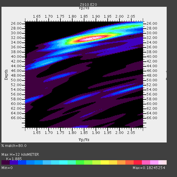
| Thickness Estimate: | 32 km |
| Thickness StdDev: | 0.4 km |
| Vp/Vs Estimate: | 1.88 |
| Vp/Vs StdDev: | 0.01 |
| Vs Estimate: | 3.483 km/s |
| Poisson's Ratio: | 0.30 |
| Peak Value: | 0.18 |
| Assumed Vp: | 6.565 km/s |
| Ps Weight: | 0.33333334 |
| PpPs Weight: | 0.33333334 |
| PsPs Weight: | 0.33333328 |
| Residual Complexity: | 0.401 |
| Nearby stations H: | +- |
| (2.0 deg) Vp/Vs: | +- |
4 with match > 90% ( 23.529411 %) and 5 with match > 80% ( 29.411764 %) out of 17.
Download stack as xyz text file.
Azimuth Distribution of Events:
Prior Results for this Station
| Study | Thickness | Vp/Vs | Vp | Vs | Poissons Ratio | Extra |
| EARS | 32 km | 1.88 | 6.565 km/s | 3.483 km/s | 0.30 | |
| Crust2.0 | 31 km | 1.78 | 6.565 km/s | 3.684 km/s | 0.27 | DG,thin Platform 1 km seds. |
| Global Maxima | 32 km | 1.88 | 6.565 km/s | 3.483 km/s | 0.30 | amp=0.18245254 |
| Local Maxima 1 | 31 km | 1.87 | 6.565 km/s | 3.51 km/s | 0.30 | amp=0.07772156 |
| Local Maxima 2 | 27 km | 2.05 | 6.565 km/s | 3.202 km/s | 0.34 | amp=0.059403792 |
| Local Maxima 3 | 42 km | 1.70 | 6.565 km/s | 3.867 km/s | 0.23 | amp=0.044382725 |
| Local Maxima 4 | 53 km | 2.06 | 6.565 km/s | 3.183 km/s | 0.35 | amp=0.03465507 |
| Predicted Arrivals for vertical incidence (zero ray parameter) | |
| Ps | 4.31 SECOND |
| PpPs | 14.06 SECOND |
| PsPs/PpSs | 18.38 SECOND |
Events Processed for this Station
Download zip of receiver functions as SAC
Plot maxima for each earthquake.
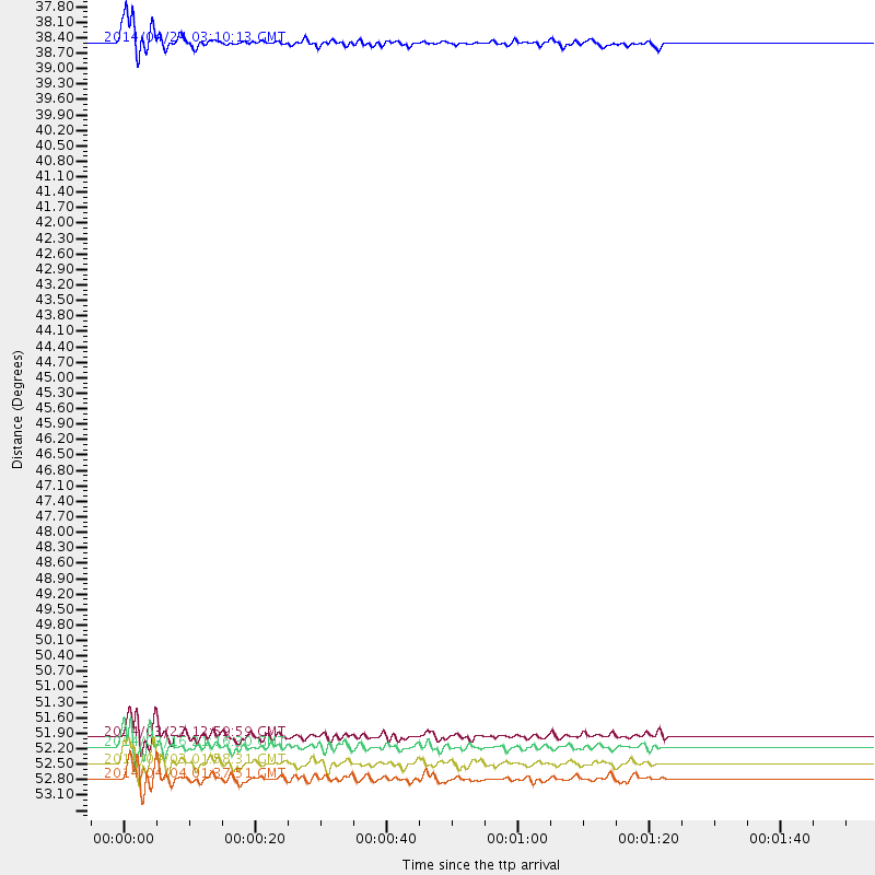
Events Used in the Stack
(5 events)| Radial Match | Distance | Baz | FERegion | Time | Lat/Lon | Depth | Magnitude |
| 94.92369 | 52.5 deg | 166.379 deg | Near Coast Of Northern Chile | 2014/03/16 21:16:30 GMT | (-19.9, -70.6) | 20 km | 6.7 MWW, 6.7 MWC, 7.0 MI |
| 91.98849 | 52.8 deg | 166.388 deg | Near Coast Of Northern Chile | 2014/04/03 01:58:31 GMT | (-20.3, -70.6) | 23 km | 6.5 MWW, 6.5 MWB, 6.6 MWC |
| 90.91822 | 38.2 deg | 311.805 deg | Vancouver Island, Canada Region | 2014/04/24 03:10:13 GMT | (49.8, -127.4) | 11 km | 6.7 MWP, 6.7 MI |
| 90.10198 | 52.3 deg | 166.622 deg | Near Coast Of Northern Chile | 2014/03/22 12:59:59 GMT | (-19.8, -70.9) | 20 km | 6.2 MWW, 6.2 MWB, 6.3 MWC, 6.4 MWC |
| 89.23755 | 53.1 deg | 166.692 deg | Near Coast Of Northern Chile | 2014/04/04 01:37:51 GMT | (-20.6, -70.7) | 20 km | 6.1 MWP, 6.1 MWB, 6.1 MWW, 6.3 MWC |
Losers
(12 events)| Radial Match | Distance | Baz | FERegion | Time | Lat/Lon | Depth | Magnitude | Reason |
| 97.786354 | 52.2 deg | 166.524 deg | Near Coast Of Northern Chile | 2014/04/01 23:46:46 GMT | (-19.6, -70.8) | 20 km | 8.2 MWW, 8.0 MI, 8.1 MWC | |
| 95.63435 | 53.1 deg | 166.388 deg | Near Coast Of Northern Chile | 2014/04/03 02:43:14 GMT | (-20.5, -70.5) | 31 km | 7.7 MWW, 7.4 MI, 7.7 MWC | |
| 88.17684 | 35.6 deg | 297.112 deg | Off Coast Of Northern California | 2014/03/10 05:18:13 GMT | (40.8, -125.1) | 17 km | 6.8 MW, 6.8 MWR, 6.9 MWW, 6.9 MWB, 7.0 MI, 7.0 MWC | |
| 78.673 | 46.0 deg | 171.252 deg | Near Coast Of Peru | 2014/02/18 23:35:58 GMT | (-14.2, -75.6) | 57 km | 6.0 MWB, 5.9 MWW, 5.9 MWC, 6.0 MWC | |
| 72.1952 | 65.9 deg | 212.247 deg | Southern East Pacific Rise | 2014/04/20 01:54:11 GMT | (-26.6, -115.0) | 10 km | 5.9 MWC, 5.9 MWC | |
| 70.65874 | 52.3 deg | 166.543 deg | Near Coast Of Northern Chile | 2014/03/23 18:20:03 GMT | (-19.7, -70.8) | 35 km | 6.0 MB, 6.2 MWB, 6.2 MWW, 6.3 MWC | |
| 67.59623 | 45.9 deg | 172.187 deg | Near Coast Of Peru | 2014/03/15 08:59:21 GMT | (-14.1, -76.3) | 20 km | 6.1 MWW, 6.0 MWB, 6.2 MWC | |
| 58.737164 | 53.3 deg | 323.89 deg | Southern Alaska | 2014/05/10 14:16:08 GMT | (60.0, -152.2) | 96 km | 5.8 ML, 5.5 MI, 5.7 MWP | |
| 52.709354 | 53.6 deg | 158.535 deg | Southern Bolivia | 2014/01/27 16:42:37 GMT | (-19.3, -63.9) | 600 km | 5.6 MWB | |
| 51.24963 | 65.0 deg | 318.899 deg | Fox Islands, Aleutian Islands | 2014/02/26 21:13:40 GMT | (53.6, -171.8) | 265 km | 6.1 MWW, 5.9 MI, 5.9 ML, 6.1 MWC, 6.1 MWB, 6.2 MWC | |
| 50.71275 | 57.4 deg | 333.404 deg | Northern Alaska | 2014/05/03 08:57:12 GMT | (67.6, -162.2) | 0.9 km | 5.5 MB | |
| 45.882404 | 77.3 deg | 175.772 deg | Off Coast Of Southern Chile | 2014/03/02 17:03:43 GMT | (-45.8, -76.2) | 10 km | 5.4 MW |

