
Station Z9 E22R - River Crossing, Odum, GA
Network: Z910 - Southeastern Suture of the Appalachian Margin Experiment
Nearby stations (2 deg radius)
| Station | Name | (Lat, Lon) | Start / End | Elevation |
| E22R | River Crossing, Odum, GA | (31.85, -82.09) | 2013-10-10 / 2014-05-21 | 39 m |
| Crust2 Type: | DG,thin Platform 1 km seds. |
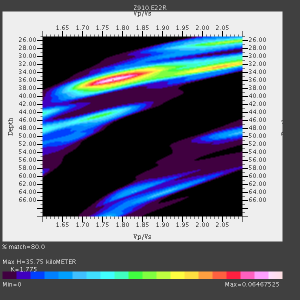
| Thickness Estimate: | 36 km |
| Thickness StdDev: | 3.1 km |
| Vp/Vs Estimate: | 1.77 |
| Vp/Vs StdDev: | 0.11 |
| Vs Estimate: | 3.698 km/s |
| Poisson's Ratio: | 0.27 |
| Peak Value: | 0.06 |
| Assumed Vp: | 6.565 km/s |
| Ps Weight: | 0.33333334 |
| PpPs Weight: | 0.33333334 |
| PsPs Weight: | 0.33333328 |
| Residual Complexity: | 0.633 |
| Nearby stations H: | +- |
| (2.0 deg) Vp/Vs: | +- |
4 with match > 90% ( 10.526316 %) and 6 with match > 80% ( 15.789474 %) out of 38.
Download stack as xyz text file.
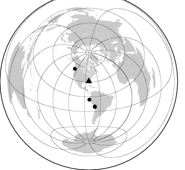
Azimuth Distribution of Events:
Prior Results for this Station
| Study | Thickness | Vp/Vs | Vp | Vs | Poissons Ratio | Extra |
| EARS | 36 km | 1.77 | 6.565 km/s | 3.698 km/s | 0.27 | |
| Crust2.0 | 31 km | 1.78 | 6.565 km/s | 3.684 km/s | 0.27 | DG,thin Platform 1 km seds. |
| Global Maxima | 36 km | 1.77 | 6.565 km/s | 3.698 km/s | 0.27 | amp=0.06467525 |
| Local Maxima 1 | 26 km | 2.09 | 6.565 km/s | 3.148 km/s | 0.35 | amp=0.03494233 |
| Local Maxima 2 | 32 km | 2.09 | 6.565 km/s | 3.145 km/s | 0.35 | amp=0.034305386 |
| Local Maxima 3 | 45 km | 1.74 | 6.565 km/s | 3.773 km/s | 0.25 | amp=0.03034204 |
| Local Maxima 4 | 37 km | 1.79 | 6.565 km/s | 3.667 km/s | 0.27 | amp=0.020376716 |
| Predicted Arrivals for vertical incidence (zero ray parameter) | |
| Ps | 4.22 SECOND |
| PpPs | 15.11 SECOND |
| PsPs/PpSs | 19.33 SECOND |
Events Processed for this Station
Download zip of receiver functions as SAC
Plot maxima for each earthquake.
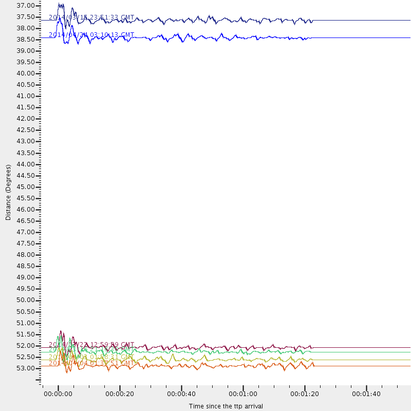
Events Used in the Stack
(6 events)| Radial Match | Distance | Baz | FERegion | Time | Lat/Lon | Depth | Magnitude |
| 95.724045 | 52.6 deg | 166.394 deg | Near Coast Of Northern Chile | 2014/03/16 21:16:30 GMT | (-19.9, -70.6) | 20 km | 6.7 MWW, 6.7 MWC, 7.0 MI |
| 92.73494 | 38.0 deg | 311.664 deg | Vancouver Island, Canada Region | 2014/04/24 03:10:13 GMT | (49.8, -127.4) | 11 km | 6.7 MWP, 6.7 MI |
| 92.51781 | 52.4 deg | 166.637 deg | Near Coast Of Northern Chile | 2014/03/22 12:59:59 GMT | (-19.8, -70.9) | 20 km | 6.2 MWW, 6.2 MWB, 6.3 MWC, 6.4 MWC |
| 91.55423 | 53.0 deg | 166.403 deg | Near Coast Of Northern Chile | 2014/04/03 01:58:31 GMT | (-20.3, -70.6) | 23 km | 6.5 MWW, 6.5 MWB, 6.6 MWC |
| 89.328705 | 37.2 deg | 178.135 deg | Near Coast Of Northern Peru | 2014/03/15 23:51:33 GMT | (-5.6, -81.0) | 29 km | 6.3 MWW, 6.2 MWB, 6.3 MWC |
| 87.49294 | 53.3 deg | 166.706 deg | Near Coast Of Northern Chile | 2014/04/04 01:37:51 GMT | (-20.6, -70.7) | 20 km | 6.1 MWP, 6.1 MWB, 6.1 MWW, 6.3 MWC |
Losers
(32 events)| Radial Match | Distance | Baz | FERegion | Time | Lat/Lon | Depth | Magnitude | Reason |
| 98.30339 | 52.3 deg | 166.539 deg | Near Coast Of Northern Chile | 2014/04/01 23:46:46 GMT | (-19.6, -70.8) | 20 km | 8.2 MWW, 8.0 MI, 8.1 MWC | |
| 96.51479 | 53.2 deg | 166.403 deg | Near Coast Of Northern Chile | 2014/04/03 02:43:14 GMT | (-20.5, -70.5) | 31 km | 7.7 MWW, 7.4 MI, 7.7 MWC | |
| 91.71984 | 35.5 deg | 296.925 deg | Off Coast Of Northern California | 2014/03/10 05:18:13 GMT | (40.8, -125.1) | 17 km | 6.8 MW, 6.8 MWR, 6.9 MWW, 6.9 MWB, 7.0 MI, 7.0 MWC | |
| 79.54164 | 53.4 deg | 166.721 deg | Near Coast Of Northern Chile | 2014/04/11 00:01:44 GMT | (-20.7, -70.7) | 18 km | 6.0 MB | |
| 75.61798 | 46.2 deg | 171.261 deg | Near Coast Of Peru | 2014/02/18 23:35:58 GMT | (-14.2, -75.6) | 57 km | 6.0 MWB, 5.9 MWW, 5.9 MWC, 6.0 MWC | |
| 73.873726 | 53.5 deg | 166.575 deg | Near Coast Of Northern Chile | 2014/04/03 05:28:50 GMT | (-20.8, -70.6) | 11 km | 5.6 mb | |
| 72.69043 | 52.7 deg | 166.399 deg | Near Coast Of Northern Chile | 2014/04/02 00:37:49 GMT | (-20.0, -70.6) | 20 km | 5.4 mb | |
| 72.14163 | 53.5 deg | 166.537 deg | Near Coast Of Northern Chile | 2014/04/03 05:26:16 GMT | (-20.8, -70.5) | 24 km | 6.2 MWP, 6.2 MWR, 6.3 MWW, 6.5 MWC | |
| 69.25062 | 52.3 deg | 166.156 deg | Near Coast Of Northern Chile | 2014/04/02 00:04:54 GMT | (-19.6, -70.5) | 34 km | 5.5 MB | |
| 67.34152 | 46.0 deg | 172.193 deg | Near Coast Of Peru | 2014/03/15 08:59:21 GMT | (-14.1, -76.3) | 20 km | 6.1 MWW, 6.0 MWB, 6.2 MWC | |
| 64.19746 | 86.4 deg | 200.923 deg | Southern East Pacific Rise | 2014/05/12 20:07:51 GMT | (-49.7, -115.3) | 10 km | 5.4 MW | |
| 62.186752 | 52.4 deg | 166.558 deg | Near Coast Of Northern Chile | 2014/03/23 18:20:03 GMT | (-19.7, -70.8) | 35 km | 6.0 MB, 6.2 MWB, 6.2 MWW, 6.3 MWC | |
| 57.74873 | 52.8 deg | 166.713 deg | Near Coast Of Northern Chile | 2014/04/02 04:46:18 GMT | (-20.2, -70.9) | 10 km | 5.8 MB | |
| 57.527897 | 95.0 deg | 35.523 deg | Eastern Caucasus | 2014/02/10 12:06:46 GMT | (40.3, 48.8) | 63 km | 5.5 MW | |
| 57.272884 | 53.2 deg | 166.653 deg | Near Coast Of Northern Chile | 2014/04/03 09:23:21 GMT | (-20.6, -70.7) | 15 km | 5.6 MB, 5.3 MWR | |
| 56.714687 | 53.7 deg | 158.564 deg | Southern Bolivia | 2014/01/27 16:42:37 GMT | (-19.3, -63.9) | 600 km | 5.6 MWB | |
| 56.297672 | 87.5 deg | 326.221 deg | Kuril Islands | 2014/01/15 10:25:14 GMT | (47.1, 152.3) | 107 km | 4.5 mb | |
| 55.749306 | 67.7 deg | 50.615 deg | France | 2014/04/07 19:27:00 GMT | (44.5, 6.7) | 9.1 km | 5.0 MW | |
| 54.229736 | 57.2 deg | 333.36 deg | Northern Alaska | 2014/05/03 08:57:12 GMT | (67.6, -162.2) | 0.9 km | 5.5 MB | |
| 52.97641 | 70.0 deg | 318.346 deg | Andreanof Islands, Aleutian Is. | 2014/01/16 07:33:09 GMT | (51.2, -179.2) | 27 km | 5.5 MWB, 5.2 ML, 5.5 ML, 5.6 MWC | |
| 52.1214 | 92.7 deg | 330.509 deg | Hokkaido, Japan Region | 2014/02/20 23:12:38 GMT | (45.9, 142.6) | 324 km | 5.2 MW | |
| 50.25683 | 51.9 deg | 166.65 deg | Near Coast Of Northern Chile | 2014/05/05 09:02:55 GMT | (-19.3, -71.0) | 21 km | 4.9 MW | |
| 49.58823 | 92.2 deg | 326.176 deg | Kuril Islands | 2014/02/23 04:54:18 GMT | (43.5, 147.8) | 20 km | 5.5 MWC, 5.3 MWB, 5.5 MWC | |
| 49.23538 | 53.1 deg | 323.824 deg | Southern Alaska | 2014/05/10 14:16:08 GMT | (60.0, -152.2) | 96 km | 5.8 ML, 5.5 MI, 5.7 MWP | |
| 47.486786 | 64.9 deg | 318.851 deg | Fox Islands, Aleutian Islands | 2014/02/26 21:13:40 GMT | (53.6, -171.8) | 265 km | 6.1 MWW, 5.9 MI, 5.9 ML, 6.1 MWC, 6.1 MWB, 6.2 MWC | |
| 47.01227 | 98.3 deg | 324.659 deg | Off East Coast Of Honshu, Japan | 2014/05/02 09:15:20 GMT | (37.9, 144.2) | 15 km | 5.9 MWP | |
| 46.505013 | 37.3 deg | 178.131 deg | Near Coast Of Northern Peru | 2014/03/22 00:38:45 GMT | (-5.6, -81.0) | 37 km | 4.9 mb | |
| 43.348267 | 56.9 deg | 165.908 deg | Northern Chile | 2014/03/20 18:41:32 GMT | (-24.0, -69.2) | 96 km | 5.1 MW | |
| 42.781322 | 82.5 deg | 50.75 deg | Southern Greece | 2014/04/04 20:08:07 GMT | (37.2, 23.8) | 107 km | 5.5 MWB, 5.5 MWR, 5.6 MWC, 5.6 MWW | |
| 38.19461 | 52.8 deg | 166.695 deg | Near Coast Of Northern Chile | 2014/04/02 06:29:16 GMT | (-20.1, -70.8) | 15 km | 5.2 mb | |
| 34.191837 | 69.9 deg | 196.386 deg | Southeast Of Easter Island | 2014/04/15 13:31:33 GMT | (-36.1, -101.2) | 14 km | 5.6 MW | |
| 22.334211 | 69.2 deg | 192.584 deg | West Chile Rise | 2014/05/06 20:52:29 GMT | (-36.3, -96.7) | 14 km | 5.9 MWB |

