
Station Z9 E24 - McLeod Property, Glennville, GA
Network: Z910 - Southeastern Suture of the Appalachian Margin Experiment
Nearby stations (2 deg radius)
| Station | Name | (Lat, Lon) | Start / End | Elevation |
| E24 | McLeod Property, Glennville, GA | (31.94, -82.10) | 2012-05-07 / 2014-05-21 | 40 m |
| Crust2 Type: | DG,thin Platform 1 km seds. |
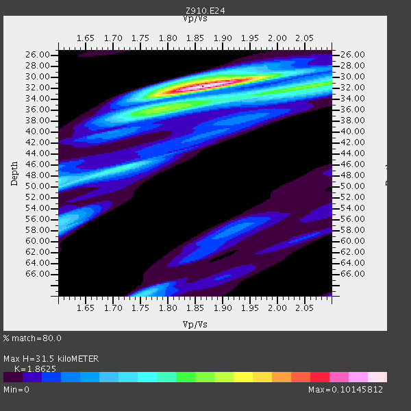
| Thickness Estimate: | 32 km |
| Thickness StdDev: | 7.9 km |
| Vp/Vs Estimate: | 1.86 |
| Vp/Vs StdDev: | 0.08 |
| Vs Estimate: | 3.525 km/s |
| Poisson's Ratio: | 0.30 |
| Peak Value: | 0.10 |
| Assumed Vp: | 6.565 km/s |
| Ps Weight: | 0.33333334 |
| PpPs Weight: | 0.33333334 |
| PsPs Weight: | 0.33333328 |
| Residual Complexity: | 0.606 |
| Nearby stations H: | +- |
| (2.0 deg) Vp/Vs: | +- |
2 with match > 90% ( 5.882353 %) and 5 with match > 80% ( 14.705882 %) out of 34.
Download stack as xyz text file.
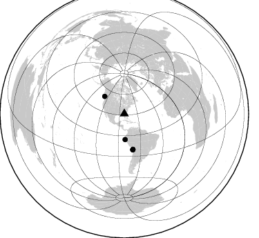
Azimuth Distribution of Events:
Prior Results for this Station
| Study | Thickness | Vp/Vs | Vp | Vs | Poissons Ratio | Extra |
| EARS | 32 km | 1.86 | 6.565 km/s | 3.525 km/s | 0.30 | |
| Crust2.0 | 31 km | 1.78 | 6.565 km/s | 3.684 km/s | 0.27 | DG,thin Platform 1 km seds. |
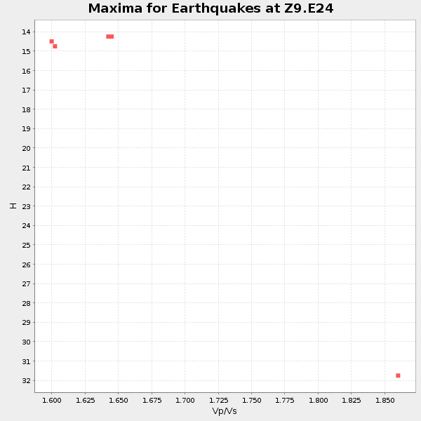
| Global Maxima | 32 km | 1.86 | 6.565 km/s | 3.525 km/s | 0.30 | amp=0.10145812 |
| Local Maxima 1 | 32 km | 2.06 | 6.565 km/s | 3.191 km/s | 0.35 | amp=0.05272481 |
| Local Maxima 2 | 46 km | 1.71 | 6.565 km/s | 3.85 km/s | 0.24 | amp=0.041048408 |
| Local Maxima 3 | 70 km | 1.75 | 6.565 km/s | 3.757 km/s | 0.26 | amp=0.035262275 |
| Local Maxima 4 | 36 km | 1.81 | 6.565 km/s | 3.622 km/s | 0.28 | amp=0.032639254 |
| Predicted Arrivals for vertical incidence (zero ray parameter) | |
| Ps | 4.14 SECOND |
| PpPs | 13.74 SECOND |
| PsPs/PpSs | 17.87 SECOND |
Events Processed for this Station
Download zip of receiver functions as SAC
Plot maxima for each earthquake.
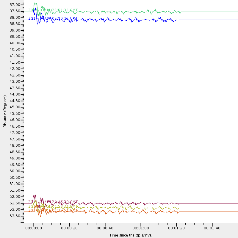
Events Used in the Stack
(5 events)| Radial Match | Distance | Baz | FERegion | Time | Lat/Lon | Depth | Magnitude |
| 95.0071 | 52.7 deg | 166.403 deg | Near Coast Of Northern Chile | 2014/03/16 21:16:30 GMT | (-19.9, -70.6) | 20 km | 6.7 MWW, 6.7 MWC, 7.0 MI |
| 94.574 | 53.1 deg | 166.412 deg | Near Coast Of Northern Chile | 2014/04/03 01:58:31 GMT | (-20.3, -70.6) | 23 km | 6.5 MWW, 6.5 MWB, 6.6 MWC |
| 89.60031 | 53.4 deg | 166.714 deg | Near Coast Of Northern Chile | 2014/04/04 01:37:51 GMT | (-20.6, -70.7) | 20 km | 6.1 MWP, 6.1 MWB, 6.1 MWW, 6.3 MWC |
| 87.96905 | 38.0 deg | 311.573 deg | Vancouver Island, Canada Region | 2014/04/24 03:10:13 GMT | (49.8, -127.4) | 11 km | 6.7 MWP, 6.7 MI |
| 82.98379 | 37.3 deg | 178.128 deg | Near Coast Of Northern Peru | 2014/03/15 23:51:33 GMT | (-5.6, -81.0) | 29 km | 6.3 MWW, 6.2 MWB, 6.3 MWC |
Losers
(29 events)| Radial Match | Distance | Baz | FERegion | Time | Lat/Lon | Depth | Magnitude | Reason |
| 98.14612 | 52.4 deg | 166.548 deg | Near Coast Of Northern Chile | 2014/04/01 23:46:46 GMT | (-19.6, -70.8) | 20 km | 8.2 MWW, 8.0 MI, 8.1 MWC | |
| 96.47754 | 53.3 deg | 166.411 deg | Near Coast Of Northern Chile | 2014/04/03 02:43:14 GMT | (-20.5, -70.5) | 31 km | 7.7 MWW, 7.4 MI, 7.7 MWC | |
| 90.44082 | 52.5 deg | 166.646 deg | Near Coast Of Northern Chile | 2014/03/22 12:59:59 GMT | (-19.8, -70.9) | 20 km | 6.2 MWW, 6.2 MWB, 6.3 MWC, 6.4 MWC | |
| 87.54988 | 35.5 deg | 296.804 deg | Off Coast Of Northern California | 2014/03/10 05:18:13 GMT | (40.8, -125.1) | 17 km | 6.8 MW, 6.8 MWR, 6.9 MWW, 6.9 MWB, 7.0 MI, 7.0 MWC | |
| 84.21468 | 46.3 deg | 171.265 deg | Near Coast Of Peru | 2014/02/18 23:35:58 GMT | (-14.2, -75.6) | 57 km | 6.0 MWB, 5.9 MWW, 5.9 MWC, 6.0 MWC | |
| 81.60438 | 53.5 deg | 166.729 deg | Near Coast Of Northern Chile | 2014/04/11 00:01:44 GMT | (-20.7, -70.7) | 18 km | 6.0 MB | |
| 76.16961 | 53.6 deg | 166.583 deg | Near Coast Of Northern Chile | 2014/04/03 05:28:50 GMT | (-20.8, -70.6) | 11 km | 5.6 mb | |
| 73.123314 | 53.3 deg | 166.661 deg | Near Coast Of Northern Chile | 2014/04/03 09:23:21 GMT | (-20.6, -70.7) | 15 km | 5.6 MB, 5.3 MWR | |
| 72.17669 | 53.6 deg | 166.545 deg | Near Coast Of Northern Chile | 2014/04/03 05:26:16 GMT | (-20.8, -70.5) | 24 km | 6.2 MWP, 6.2 MWR, 6.3 MWW, 6.5 MWC | |
| 67.398445 | 46.1 deg | 172.197 deg | Near Coast Of Peru | 2014/03/15 08:59:21 GMT | (-14.1, -76.3) | 20 km | 6.1 MWW, 6.0 MWB, 6.2 MWC | |
| 66.832184 | 52.4 deg | 166.667 deg | Near Coast Of Northern Chile | 2014/04/02 01:20:59 GMT | (-19.6, -70.9) | 22 km | 5.2 mb | |
| 64.6839 | 52.8 deg | 166.709 deg | Near Coast Of Northern Chile | 2014/03/17 05:11:34 GMT | (-20.0, -70.9) | 17 km | 6.2 MWW, 6.2 MWB, 6.5 MWC | |
| 62.675873 | 57.2 deg | 333.332 deg | Northern Alaska | 2014/05/03 08:57:12 GMT | (67.6, -162.2) | 0.9 km | 5.5 MB | |
| 61.397343 | 53.1 deg | 323.781 deg | Southern Alaska | 2014/05/10 14:16:08 GMT | (60.0, -152.2) | 96 km | 5.8 ML, 5.5 MI, 5.7 MWP | |
| 59.620186 | 86.5 deg | 200.383 deg | Southern East Pacific Rise | 2014/05/12 18:38:37 GMT | (-50.0, -114.7) | 8.2 km | 5.8 MB | |
| 58.307823 | 70.0 deg | 318.321 deg | Andreanof Islands, Aleutian Is. | 2014/01/16 07:33:09 GMT | (51.2, -179.2) | 27 km | 5.5 MWB, 5.2 ML, 5.5 ML, 5.6 MWC | |
| 56.514576 | 53.8 deg | 158.582 deg | Southern Bolivia | 2014/01/27 16:42:37 GMT | (-19.3, -63.9) | 600 km | 5.6 MWB | |
| 55.132236 | 82.4 deg | 50.757 deg | Southern Greece | 2014/04/04 20:08:07 GMT | (37.2, 23.8) | 107 km | 5.5 MWB, 5.5 MWR, 5.6 MWC, 5.6 MWW | |
| 52.884705 | 52.9 deg | 166.346 deg | Near Coast Of Northern Chile | 2014/04/11 12:00:51 GMT | (-20.1, -70.5) | 22 km | 5.5 MB | |
| 52.80571 | 52.7 deg | 166.808 deg | Near Coast Of Northern Chile | 2014/04/02 11:07:33 GMT | (-20.0, -71.0) | 27 km | 5.4 Mww | |
| 50.874454 | 64.8 deg | 318.819 deg | Fox Islands, Aleutian Islands | 2014/02/26 21:13:40 GMT | (53.6, -171.8) | 265 km | 6.1 MWW, 5.9 MI, 5.9 ML, 6.1 MWC, 6.1 MWB, 6.2 MWC | |
| 49.969685 | 52.4 deg | 166.538 deg | Near Coast Of Northern Chile | 2014/03/24 15:45:31 GMT | (-19.6, -70.8) | 18 km | 5.6 MWB, 5.5 MWR, 5.7 MWC, 5.7 MWW | |
| 49.66364 | 69.3 deg | 192.57 deg | West Chile Rise | 2014/05/06 20:52:29 GMT | (-36.3, -96.7) | 14 km | 5.9 MWB | |
| 43.77723 | 52.5 deg | 166.782 deg | Near Coast Of Northern Chile | 2014/03/22 22:14:57 GMT | (-19.7, -71.0) | 19 km | 5.1 MW | |
| 42.82843 | 30.2 deg | 174.542 deg | Near Coast Of Ecuador | 2014/03/09 20:29:52 GMT | (1.7, -79.4) | 6.0 km | 5.6 MWW, 5.6 MWC, 5.6 MWB | |
| 42.23432 | 53.0 deg | 166.593 deg | Near Coast Of Northern Chile | 2014/05/05 11:21:19 GMT | (-20.2, -70.7) | 24 km | 5.4 MW | |
| 39.504395 | 70.0 deg | 196.37 deg | Southeast Of Easter Island | 2014/04/15 13:31:33 GMT | (-36.1, -101.2) | 14 km | 5.6 MW | |
| 39.300877 | 52.5 deg | 166.567 deg | Near Coast Of Northern Chile | 2014/03/23 18:20:03 GMT | (-19.7, -70.8) | 35 km | 6.0 MB, 6.2 MWB, 6.2 MWW, 6.3 MWC | |
| 15.328584 | 53.2 deg | 166.916 deg | Near Coast Of Northern Chile | 2014/04/06 14:06:09 GMT | (-20.4, -71.0) | 20 km | 5.3 MW |

