
Station Z9 E25 - Sikes Property, Reidsville, GA
Network: Z910 - Southeastern Suture of the Appalachian Margin Experiment
Nearby stations (2 deg radius)
| Station | Name | (Lat, Lon) | Start / End | Elevation |
| E25 | Sikes Property, Reidsville, GA | (31.99, -82.11) | 2012-05-17 / 2014-05-16 | 46 m |
| Crust2 Type: | DG,thin Platform 1 km seds. |
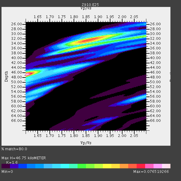
| Thickness Estimate: | 47 km |
| Thickness StdDev: | 7.1 km |
| Vp/Vs Estimate: | 1.60 |
| Vp/Vs StdDev: | 0.12 |
| Vs Estimate: | 4.103 km/s |
| Poisson's Ratio: | 0.18 |
| Peak Value: | 0.08 |
| Assumed Vp: | 6.565 km/s |
| Ps Weight: | 0.33333334 |
| PpPs Weight: | 0.33333334 |
| PsPs Weight: | 0.33333328 |
| Residual Complexity: | 0.862 |
| Nearby stations H: | +- |
| (2.0 deg) Vp/Vs: | +- |
1 with match > 90% ( 4.5454545 %) and 4 with match > 80% ( 18.181818 %) out of 22.
Download stack as xyz text file.
Azimuth Distribution of Events:
Prior Results for this Station
| Study | Thickness | Vp/Vs | Vp | Vs | Poissons Ratio | Extra |
| EARS | 47 km | 1.60 | 6.565 km/s | 4.103 km/s | 0.18 | |
| Crust2.0 | 31 km | 1.78 | 6.565 km/s | 3.684 km/s | 0.27 | DG,thin Platform 1 km seds. |
| Global Maxima | 47 km | 1.60 | 6.565 km/s | 4.103 km/s | 0.18 | amp=0.076519266 |
| Local Maxima 1 | 32 km | 1.86 | 6.565 km/s | 3.525 km/s | 0.30 | amp=0.05987525 |
| Local Maxima 2 | 31 km | 2.08 | 6.565 km/s | 3.152 km/s | 0.35 | amp=0.03822235 |
| Local Maxima 3 | 36 km | 1.83 | 6.565 km/s | 3.597 km/s | 0.29 | amp=0.03203706 |
| Local Maxima 4 | 52 km | 1.68 | 6.565 km/s | 3.919 km/s | 0.22 | amp=0.031160053 |
| Predicted Arrivals for vertical incidence (zero ray parameter) | |
| Ps | 4.27 SECOND |
| PpPs | 18.52 SECOND |
| PsPs/PpSs | 22.79 SECOND |
Events Processed for this Station
Download zip of receiver functions as SAC
Plot maxima for each earthquake.
Events Used in the Stack
(4 events)| Radial Match | Distance | Baz | FERegion | Time | Lat/Lon | Depth | Magnitude |
| 94.60443 | 52.8 deg | 166.393 deg | Near Coast Of Northern Chile | 2014/03/16 21:16:30 GMT | (-19.9, -70.6) | 20 km | 6.7 MWW, 6.7 MWC, 7.0 MI |
| 88.62856 | 53.4 deg | 166.703 deg | Near Coast Of Northern Chile | 2014/04/04 01:37:51 GMT | (-20.6, -70.7) | 20 km | 6.1 MWP, 6.1 MWB, 6.1 MWW, 6.3 MWC |
| 85.91472 | 37.4 deg | 178.103 deg | Near Coast Of Northern Peru | 2014/03/15 23:51:33 GMT | (-5.6, -81.0) | 29 km | 6.3 MWW, 6.2 MWB, 6.3 MWC |
| 85.54344 | 37.9 deg | 311.531 deg | Vancouver Island, Canada Region | 2014/04/24 03:10:13 GMT | (49.8, -127.4) | 11 km | 6.7 MWP, 6.7 MI |
Losers
(18 events)| Radial Match | Distance | Baz | FERegion | Time | Lat/Lon | Depth | Magnitude | Reason |
| 98.56709 | 52.5 deg | 166.537 deg | Near Coast Of Northern Chile | 2014/04/01 23:46:46 GMT | (-19.6, -70.8) | 20 km | 8.2 MWW, 8.0 MI, 8.1 MWC | |
| 96.41682 | 53.4 deg | 166.401 deg | Near Coast Of Northern Chile | 2014/04/03 02:43:14 GMT | (-20.5, -70.5) | 31 km | 7.7 MWW, 7.4 MI, 7.7 MWC | |
| 87.55823 | 35.4 deg | 296.745 deg | Off Coast Of Northern California | 2014/03/10 05:18:13 GMT | (40.8, -125.1) | 17 km | 6.8 MW, 6.8 MWR, 6.9 MWW, 6.9 MWB, 7.0 MI, 7.0 MWC | |
| 82.028946 | 46.3 deg | 171.25 deg | Near Coast Of Peru | 2014/02/18 23:35:58 GMT | (-14.2, -75.6) | 57 km | 6.0 MWB, 5.9 MWW, 5.9 MWC, 6.0 MWC | |
| 76.19379 | 53.0 deg | 166.711 deg | Near Coast Of Northern Chile | 2014/04/02 04:46:18 GMT | (-20.2, -70.9) | 10 km | 5.8 MB | |
| 73.98126 | 53.7 deg | 166.534 deg | Near Coast Of Northern Chile | 2014/04/03 05:26:16 GMT | (-20.8, -70.5) | 24 km | 6.2 MWP, 6.2 MWR, 6.3 MWW, 6.5 MWC | |
| 72.915596 | 53.7 deg | 166.572 deg | Near Coast Of Northern Chile | 2014/04/03 05:28:50 GMT | (-20.8, -70.6) | 11 km | 5.6 mb | |
| 68.365715 | 52.6 deg | 166.557 deg | Near Coast Of Northern Chile | 2014/03/23 18:20:03 GMT | (-19.7, -70.8) | 35 km | 6.0 MB, 6.2 MWB, 6.2 MWW, 6.3 MWC | |
| 64.67663 | 52.4 deg | 166.657 deg | Near Coast Of Northern Chile | 2014/04/02 01:20:59 GMT | (-19.6, -70.9) | 22 km | 5.2 mb | |
| 64.50205 | 46.2 deg | 172.181 deg | Near Coast Of Peru | 2014/03/15 08:59:21 GMT | (-14.1, -76.3) | 20 km | 6.1 MWW, 6.0 MWB, 6.2 MWC | |
| 62.510227 | 52.4 deg | 166.527 deg | Near Coast Of Northern Chile | 2014/03/24 15:45:31 GMT | (-19.6, -70.8) | 18 km | 5.6 MWB, 5.5 MWR, 5.7 MWC, 5.7 MWW | |
| 57.855038 | 57.1 deg | 333.318 deg | Northern Alaska | 2014/05/03 08:57:12 GMT | (67.6, -162.2) | 0.9 km | 5.5 MB | |
| 56.759914 | 53.2 deg | 166.905 deg | Near Coast Of Northern Chile | 2014/04/06 14:06:09 GMT | (-20.4, -71.0) | 20 km | 5.3 MW | |
| 56.388474 | 77.6 deg | 176.053 deg | Off Coast Of Southern Chile | 2014/03/02 16:18:30 GMT | (-45.9, -76.6) | 23 km | 5.0 MW | |
| 53.835194 | 64.8 deg | 318.801 deg | Fox Islands, Aleutian Islands | 2014/02/26 21:13:40 GMT | (53.6, -171.8) | 265 km | 6.1 MWW, 5.9 MI, 5.9 ML, 6.1 MWC, 6.1 MWB, 6.2 MWC | |
| 51.419945 | 69.9 deg | 318.304 deg | Andreanof Islands, Aleutian Is. | 2014/01/16 07:33:09 GMT | (51.2, -179.2) | 27 km | 5.5 MWB, 5.2 ML, 5.5 ML, 5.6 MWC | |
| 42.77206 | 79.2 deg | 114.15 deg | Southern Mid-Atlantic Ridge | 2014/02/20 04:09:57 GMT | (-14.1, -14.6) | 14 km | 5.1 MW | |
| 39.095837 | 53.9 deg | 158.576 deg | Southern Bolivia | 2014/01/27 16:42:37 GMT | (-19.3, -63.9) | 600 km | 5.6 MWB |

