
Station Z9 W02 - Turtle Dove Plantation, Monticello, FL
Network: Z910 - Southeastern Suture of the Appalachian Margin Experiment
Nearby stations (2 deg radius)
| Station | Name | (Lat, Lon) | Start / End | Elevation |
| W02 | Turtle Dove Plantation, Monticello, FL | (30.58, -83.89) | 2011-05-13 / 2014-05-14 | 47 m |
| Crust2 Type: | DG,thin Platform 1 km seds. |
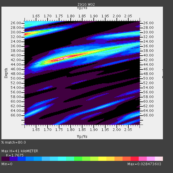
| Thickness Estimate: | 41 km |
| Thickness StdDev: | 4.6 km |
| Vp/Vs Estimate: | 1.77 |
| Vp/Vs StdDev: | 0.17 |
| Vs Estimate: | 3.714 km/s |
| Poisson's Ratio: | 0.26 |
| Peak Value: | 0.03 |
| Assumed Vp: | 6.565 km/s |
| Ps Weight: | 0.33333334 |
| PpPs Weight: | 0.33333334 |
| PsPs Weight: | 0.33333328 |
| Residual Complexity: | 0.658 |
| Nearby stations H: | +- |
| (2.0 deg) Vp/Vs: | +- |
1 with match > 90% ( 3.7037036 %) and 4 with match > 80% ( 14.814815 %) out of 27.
Download stack as xyz text file.
Azimuth Distribution of Events:
Prior Results for this Station
| Study | Thickness | Vp/Vs | Vp | Vs | Poissons Ratio | Extra |
| EARS | 41 km | 1.77 | 6.565 km/s | 3.714 km/s | 0.26 | |
| Crust2.0 | 31 km | 1.78 | 6.565 km/s | 3.684 km/s | 0.27 | DG,thin Platform 1 km seds. |
| Global Maxima | 41 km | 1.77 | 6.565 km/s | 3.714 km/s | 0.26 | amp=0.028473603 |
| Local Maxima 1 | 31 km | 1.60 | 6.565 km/s | 4.103 km/s | 0.18 | amp=0.023412019 |
| Local Maxima 2 | 37 km | 1.94 | 6.565 km/s | 3.384 km/s | 0.32 | amp=0.012619752 |
| Local Maxima 3 | 27 km | 1.60 | 6.565 km/s | 4.103 km/s | 0.18 | amp=0.011863033 |
| Local Maxima 4 | 30 km | 2.05 | 6.565 km/s | 3.202 km/s | 0.34 | amp=0.011111174 |
| Predicted Arrivals for vertical incidence (zero ray parameter) | |
| Ps | 4.79 SECOND |
| PpPs | 17.28 SECOND |
| PsPs/PpSs | 22.08 SECOND |
Events Processed for this Station
Download zip of receiver functions as SAC
Plot maxima for each earthquake.
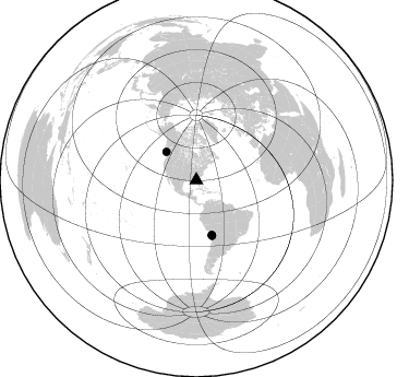
Events Used in the Stack
(4 events)| Radial Match | Distance | Baz | FERegion | Time | Lat/Lon | Depth | Magnitude |
| 90.11932 | 37.8 deg | 313.273 deg | Vancouver Island, Canada Region | 2014/04/24 03:10:13 GMT | (49.8, -127.4) | 11 km | 6.7 MWP, 6.7 MI |
| 87.960884 | 51.8 deg | 164.059 deg | Near Coast Of Northern Chile | 2014/03/16 21:16:30 GMT | (-19.9, -70.6) | 20 km | 6.7 MWW, 6.7 MWC, 7.0 MI |
| 85.70955 | 52.2 deg | 164.085 deg | Near Coast Of Northern Chile | 2014/04/03 01:58:31 GMT | (-20.3, -70.6) | 23 km | 6.5 MWW, 6.5 MWB, 6.6 MWC |
| 85.60459 | 52.7 deg | 164.247 deg | Near Coast Of Northern Chile | 2014/04/03 05:26:16 GMT | (-20.8, -70.5) | 24 km | 6.2 MWP, 6.2 MWR, 6.3 MWW, 6.5 MWC |
Losers
(23 events)| Radial Match | Distance | Baz | FERegion | Time | Lat/Lon | Depth | Magnitude | Reason |
| 97.825935 | 51.5 deg | 164.19 deg | Near Coast Of Northern Chile | 2014/04/01 23:46:46 GMT | (-19.6, -70.8) | 20 km | 8.2 MWW, 8.0 MI, 8.1 MWC | |
| 92.38864 | 52.4 deg | 164.098 deg | Near Coast Of Northern Chile | 2014/04/03 02:43:14 GMT | (-20.5, -70.5) | 31 km | 7.7 MWW, 7.4 MI, 7.7 MWC | |
| 90.09049 | 52.4 deg | 164.378 deg | Near Coast Of Northern Chile | 2014/04/03 04:17:57 GMT | (-20.6, -70.7) | 18 km | 5.2 mb | |
| 89.67211 | 34.7 deg | 298.611 deg | Off Coast Of Northern California | 2014/03/10 05:18:13 GMT | (40.8, -125.1) | 17 km | 6.8 MW, 6.8 MWR, 6.9 MWW, 6.9 MWB, 7.0 MI, 7.0 MWC | |
| 89.12206 | 51.5 deg | 163.803 deg | Near Coast Of Northern Chile | 2014/04/02 00:04:54 GMT | (-19.6, -70.5) | 34 km | 5.5 MB | |
| 87.52999 | 52.5 deg | 164.407 deg | Near Coast Of Northern Chile | 2014/04/04 01:37:51 GMT | (-20.6, -70.7) | 20 km | 6.1 MWP, 6.1 MWB, 6.1 MWW, 6.3 MWC | |
| 87.27248 | 36.1 deg | 175.036 deg | Near Coast Of Northern Peru | 2014/03/15 23:51:33 GMT | (-5.6, -81.0) | 29 km | 6.3 MWW, 6.2 MWB, 6.3 MWC | |
| 87.07406 | 97.4 deg | 334.076 deg | E. Russia-N.E. China Border Reg. | 2014/04/12 21:22:44 GMT | (44.9, 133.7) | 10 km | 4.3 mb | |
| 82.08564 | 51.2 deg | 164.026 deg | Near Coast Of Northern Chile | 2014/04/02 02:52:26 GMT | (-19.3, -70.8) | 17 km | 4.9 mb | |
| 81.6177 | 51.5 deg | 164.175 deg | Near Coast Of Northern Chile | 2014/04/02 00:06:44 GMT | (-19.6, -70.8) | 10 km | 5.7 MB | |
| 76.05721 | 51.6 deg | 164.294 deg | Near Coast Of Northern Chile | 2014/03/22 12:59:59 GMT | (-19.8, -70.9) | 20 km | 6.2 MWW, 6.2 MWB, 6.3 MWC, 6.4 MWC | |
| 74.59721 | 98.2 deg | 254.184 deg | Tonga Islands | 2014/02/17 12:12:05 GMT | (-17.8, -173.0) | 26 km | 5.0 MW | |
| 69.610855 | 45.0 deg | 169.572 deg | Near Coast Of Peru | 2014/03/15 08:59:21 GMT | (-14.1, -76.3) | 20 km | 6.1 MWW, 6.0 MWB, 6.2 MWC | |
| 66.38514 | 64.8 deg | 318.858 deg | Fox Islands, Aleutian Islands | 2014/02/26 21:13:40 GMT | (53.6, -171.8) | 265 km | 6.1 MWW, 5.9 MI, 5.9 ML, 6.1 MWC, 6.1 MWB, 6.2 MWC | |
| 65.2475 | 84.8 deg | 198.871 deg | Southern East Pacific Rise | 2014/04/09 08:29:25 GMT | (-50.3, -114.0) | 10 km | 5.6 MW | |
| 62.253265 | 52.0 deg | 164.009 deg | Near Coast Of Northern Chile | 2014/04/11 12:00:51 GMT | (-20.1, -70.5) | 22 km | 5.5 MB | |
| 62.11116 | 45.2 deg | 168.633 deg | Near Coast Of Peru | 2014/02/18 23:35:58 GMT | (-14.2, -75.6) | 57 km | 6.0 MWB, 5.9 MWW, 5.9 MWC, 6.0 MWC | |
| 59.12784 | 81.8 deg | 50.462 deg | Greece | 2014/01/26 13:55:42 GMT | (38.2, 20.5) | 8.0 km | 6.1 MWW, 6.1 MWB, 6.2 MWC | |
| 58.217598 | 84.5 deg | 49.823 deg | Southern Greece | 2014/04/04 20:08:07 GMT | (37.2, 23.8) | 107 km | 5.5 MWB, 5.5 MWR, 5.6 MWC, 5.6 MWW | |
| 54.39661 | 52.4 deg | 164.351 deg | Near Coast Of Northern Chile | 2014/04/03 09:23:21 GMT | (-20.6, -70.7) | 15 km | 5.6 MB, 5.3 MWR | |
| 53.561813 | 61.4 deg | 158.705 deg | Santiago Del Estero Prov., Arg. | 2014/04/18 07:46:57 GMT | (-27.7, -62.8) | 610 km | 5.6 MW | |
| 53.0416 | 52.0 deg | 164.39 deg | Near Coast Of Northern Chile | 2014/04/02 04:46:18 GMT | (-20.2, -70.9) | 10 km | 5.8 MB | |
| 50.060734 | 53.3 deg | 324.385 deg | Southern Alaska | 2014/05/10 14:16:08 GMT | (60.0, -152.2) | 96 km | 5.8 ML, 5.5 MI, 5.7 MWP |

