
Station Z9 W05 - Sells Farm, Doerun, GA
Network: Z910 - Southeastern Suture of the Appalachian Margin Experiment
Nearby stations (2 deg radius)
| Station | Name | (Lat, Lon) | Start / End | Elevation |
| W05 | Sells Farm, Doerun, GA | (31.27, -83.90) | 2011-05-13 / 2014-05-14 | 115 m |
| Crust2 Type: | DG,thin Platform 1 km seds. |
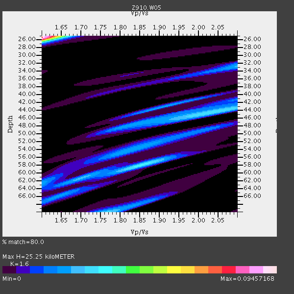
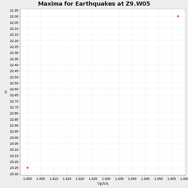
| Thickness Estimate: | 25 km |
| Thickness StdDev: | 4.5 km |
| Vp/Vs Estimate: | 1.60 |
| Vp/Vs StdDev: | 0.13 |
| Vs Estimate: | 4.103 km/s |
| Poisson's Ratio: | 0.18 |
| Peak Value: | 0.09 |
| Assumed Vp: | 6.565 km/s |
| Ps Weight: | 0.33333334 |
| PpPs Weight: | 0.33333334 |
| PsPs Weight: | 0.33333328 |
| Residual Complexity: | 0.870 |
| Nearby stations H: | +- |
| (2.0 deg) Vp/Vs: | +- |
0 with match > 90% ( 0.0 %) and 2 with match > 80% ( 10.526316 %) out of 19.
Download stack as xyz text file.
Azimuth Distribution of Events:

Prior Results for this Station
| Study | Thickness | Vp/Vs | Vp | Vs | Poissons Ratio | Extra |
| EARS | 25 km | 1.60 | 6.565 km/s | 4.103 km/s | 0.18 | |
| Crust2.0 | 31 km | 1.78 | 6.565 km/s | 3.684 km/s | 0.27 | DG,thin Platform 1 km seds. |
| Global Maxima | 25 km | 1.60 | 6.565 km/s | 4.103 km/s | 0.18 | amp=0.09457168 |
| Local Maxima 1 | 58 km | 1.86 | 6.565 km/s | 3.534 km/s | 0.30 | amp=0.034865186 |
| Local Maxima 2 | 44 km | 2.03 | 6.565 km/s | 3.238 km/s | 0.34 | amp=0.0318091 |
| Local Maxima 3 | 70 km | 1.77 | 6.565 km/s | 3.704 km/s | 0.27 | amp=0.02842892 |
| Local Maxima 4 | 33 km | 2.10 | 6.565 km/s | 3.13 km/s | 0.35 | amp=0.024622595 |
| Predicted Arrivals for vertical incidence (zero ray parameter) | |
| Ps | 2.31 SECOND |
| PpPs | 10.00 SECOND |
| PsPs/PpSs | 12.31 SECOND |
Events Processed for this Station
Download zip of receiver functions as SAC
Plot maxima for each earthquake.
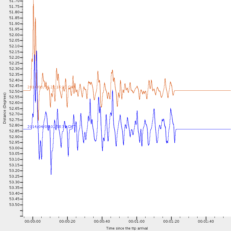
Events Used in the Stack
(2 events)| Radial Match | Distance | Baz | FERegion | Time | Lat/Lon | Depth | Magnitude |
| 89.475494 | 52.5 deg | 164.198 deg | Near Coast Of Northern Chile | 2014/03/16 21:16:30 GMT | (-19.9, -70.6) | 20 km | 6.7 MWW, 6.7 MWC, 7.0 MI |
| 83.980156 | 52.8 deg | 164.222 deg | Near Coast Of Northern Chile | 2014/04/03 01:58:31 GMT | (-20.3, -70.6) | 23 km | 6.5 MWW, 6.5 MWB, 6.6 MWC |
Losers
(17 events)| Radial Match | Distance | Baz | FERegion | Time | Lat/Lon | Depth | Magnitude | Reason |
| 97.3468 | 52.2 deg | 164.328 deg | Near Coast Of Northern Chile | 2014/04/01 23:46:46 GMT | (-19.6, -70.8) | 20 km | 8.2 MWW, 8.0 MI, 8.1 MWC | |
| 96.45362 | 52.1 deg | 164.314 deg | Near Coast Of Northern Chile | 2014/04/02 00:06:44 GMT | (-19.6, -70.8) | 10 km | 5.7 MB | |
| 92.6687 | 53.1 deg | 164.233 deg | Near Coast Of Northern Chile | 2014/04/03 02:43:14 GMT | (-20.5, -70.5) | 31 km | 7.7 MWW, 7.4 MI, 7.7 MWC | |
| 89.911964 | 34.4 deg | 297.725 deg | Off Coast Of Northern California | 2014/03/10 05:18:13 GMT | (40.8, -125.1) | 17 km | 6.8 MW, 6.8 MWR, 6.9 MWW, 6.9 MWB, 7.0 MI, 7.0 MWC | |
| 81.61783 | 52.3 deg | 164.432 deg | Near Coast Of Northern Chile | 2014/03/22 12:59:59 GMT | (-19.8, -70.9) | 20 km | 6.2 MWW, 6.2 MWB, 6.3 MWC, 6.4 MWC | |
| 79.282974 | 52.6 deg | 164.525 deg | Near Coast Of Northern Chile | 2014/04/02 04:46:18 GMT | (-20.2, -70.9) | 10 km | 5.8 MB | |
| 78.61958 | 36.8 deg | 175.104 deg | Near Coast Of Northern Peru | 2014/03/15 23:51:33 GMT | (-5.6, -81.0) | 29 km | 6.3 MWW, 6.2 MWB, 6.3 MWC | |
| 77.22307 | 53.1 deg | 164.539 deg | Near Coast Of Northern Chile | 2014/04/04 01:37:51 GMT | (-20.6, -70.7) | 20 km | 6.1 MWP, 6.1 MWB, 6.1 MWW, 6.3 MWC | |
| 74.462364 | 64.3 deg | 318.639 deg | Fox Islands, Aleutian Islands | 2014/02/26 21:13:40 GMT | (53.6, -171.8) | 265 km | 6.1 MWW, 5.9 MI, 5.9 ML, 6.1 MWC, 6.1 MWB, 6.2 MWC | |
| 68.59629 | 52.3 deg | 164.353 deg | Near Coast Of Northern Chile | 2014/03/23 18:20:03 GMT | (-19.7, -70.8) | 35 km | 6.0 MB, 6.2 MWB, 6.2 MWW, 6.3 MWC | |
| 66.39511 | 45.7 deg | 169.685 deg | Near Coast Of Peru | 2014/03/15 08:59:21 GMT | (-14.1, -76.3) | 20 km | 6.1 MWW, 6.0 MWB, 6.2 MWC | |
| 63.15134 | 45.9 deg | 168.756 deg | Near Coast Of Peru | 2014/02/18 23:35:58 GMT | (-14.2, -75.6) | 57 km | 6.0 MWB, 5.9 MWW, 5.9 MWC, 6.0 MWC | |
| 57.63022 | 33.6 deg | 171.638 deg | Near Coast Of Ecuador | 2014/03/25 09:56:28 GMT | (-2.2, -79.3) | 10 km | 5.2 MW | |
| 55.239098 | 29.8 deg | 170.814 deg | Near Coast Of Ecuador | 2014/03/09 20:29:52 GMT | (1.7, -79.4) | 6.0 km | 5.6 MWW, 5.6 MWC, 5.6 MWB | |
| 54.013515 | 55.2 deg | 162.751 deg | Northern Chile | 2014/02/10 11:00:09 GMT | (-22.3, -68.7) | 107 km | 5.2 MW | |
| 50.90959 | 92.6 deg | 167.935 deg | Drake Passage | 2014/02/27 05:10:58 GMT | (-59.5, -59.8) | 10 km | 5.3 MW | |
| 30.18022 | 53.1 deg | 164.484 deg | Near Coast Of Northern Chile | 2014/04/03 09:23:21 GMT | (-20.6, -70.7) | 15 km | 5.6 MB, 5.3 MWR |

