
Station Z9 W08 - Quail Valley Farms, Warwick, GA
Network: Z910 - Southeastern Suture of the Appalachian Margin Experiment
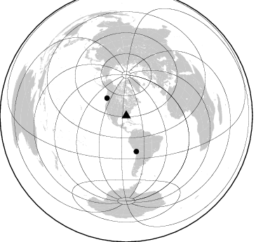
Nearby stations (2 deg radius)
| Station | Name | (Lat, Lon) | Start / End | Elevation |
| W08 | Quail Valley Farms, Warwick, GA | (31.72, -83.89) | 2011-05-12 / 2014-05-14 | 910 m |
| Crust2 Type: | DG,thin Platform 1 km seds. |
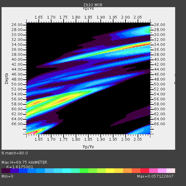
| Thickness Estimate: | 70 km |
| Thickness StdDev: | 5.9 km |
| Vp/Vs Estimate: | 1.62 |
| Vp/Vs StdDev: | 0.02 |
| Vs Estimate: | 4.058 km/s |
| Poisson's Ratio: | 0.19 |
| Peak Value: | 0.06 |
| Assumed Vp: | 6.565 km/s |
| Ps Weight: | 0.33333334 |
| PpPs Weight: | 0.33333334 |
| PsPs Weight: | 0.33333328 |
| Residual Complexity: | 0.937 |
| Nearby stations H: | +- |
| (2.0 deg) Vp/Vs: | +- |
1 with match > 90% ( 3.030303 %) and 2 with match > 80% ( 6.060606 %) out of 33.
Download stack as xyz text file.
Azimuth Distribution of Events:
Prior Results for this Station
| Study | Thickness | Vp/Vs | Vp | Vs | Poissons Ratio | Extra |
| EARS | 70 km | 1.62 | 6.565 km/s | 4.058 km/s | 0.19 | |
| Crust2.0 | 31 km | 1.78 | 6.565 km/s | 3.684 km/s | 0.27 | DG,thin Platform 1 km seds. |
| Global Maxima | 70 km | 1.62 | 6.565 km/s | 4.058 km/s | 0.19 | amp=0.057122607 |
| Local Maxima 1 | 34 km | 2.06 | 6.565 km/s | 3.191 km/s | 0.35 | amp=0.047487665 |
| Local Maxima 2 | 56 km | 1.74 | 6.565 km/s | 3.778 km/s | 0.25 | amp=0.03958176 |
| Local Maxima 3 | 57 km | 1.65 | 6.565 km/s | 3.972 km/s | 0.21 | amp=0.03489438 |
| Local Maxima 4 | 28 km | 2.10 | 6.565 km/s | 3.13 km/s | 0.35 | amp=0.026244212 |
| Predicted Arrivals for vertical incidence (zero ray parameter) | |
| Ps | 6.56 SECOND |
| PpPs | 27.81 SECOND |
| PsPs/PpSs | 34.37 SECOND |
Events Processed for this Station
Download zip of receiver functions as SAC
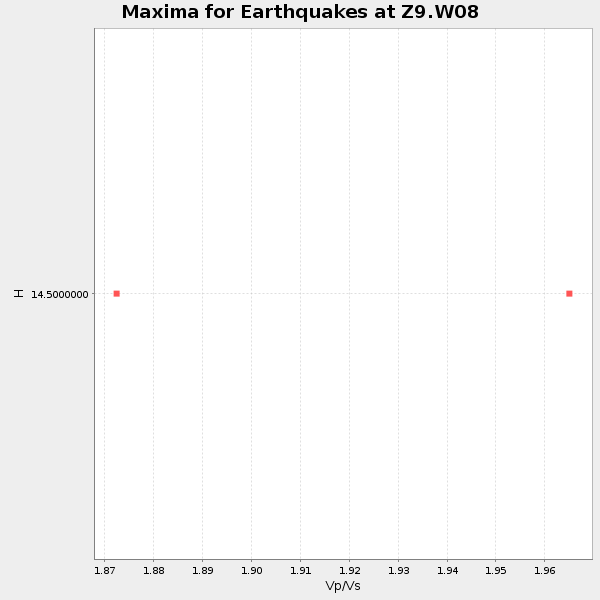
Plot maxima for each earthquake.
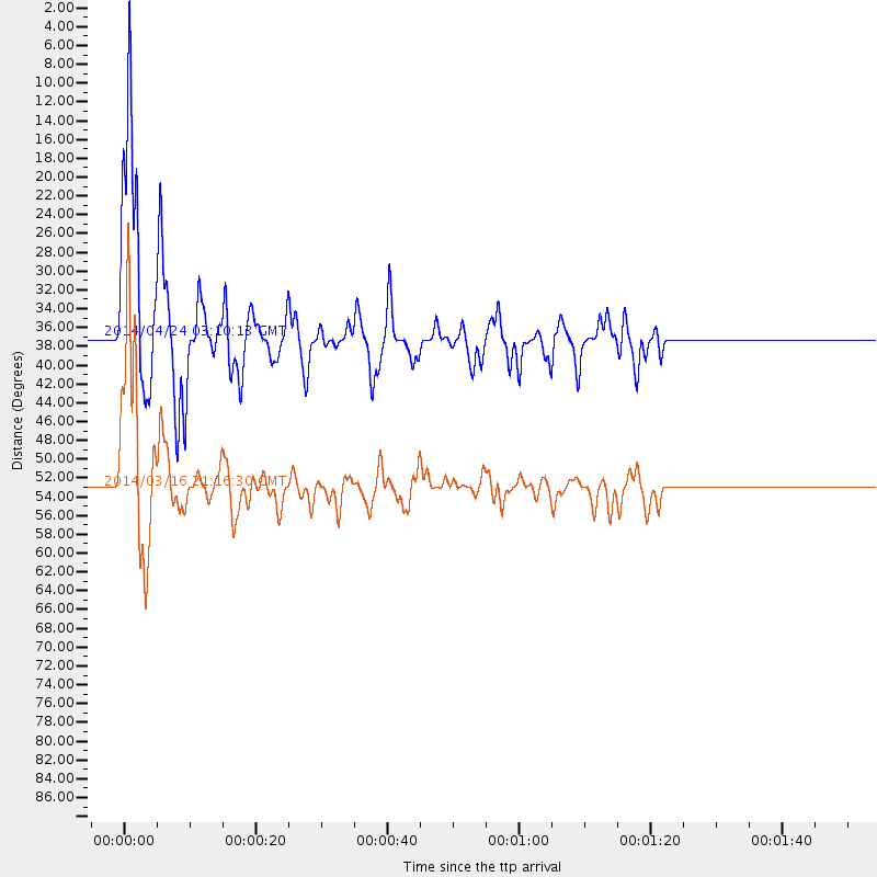
Events Used in the Stack
(2 events)| Radial Match | Distance | Baz | FERegion | Time | Lat/Lon | Depth | Magnitude |
| 92.34788 | 52.9 deg | 164.303 deg | Near Coast Of Northern Chile | 2014/03/16 21:16:30 GMT | (-19.9, -70.6) | 20 km | 6.7 MWW, 6.7 MWC, 7.0 MI |
| 89.07381 | 37.0 deg | 312.18 deg | Vancouver Island, Canada Region | 2014/04/24 03:10:13 GMT | (49.8, -127.4) | 11 km | 6.7 MWP, 6.7 MI |
Losers
(31 events)| Radial Match | Distance | Baz | FERegion | Time | Lat/Lon | Depth | Magnitude | Reason |
| 97.32145 | 52.6 deg | 164.434 deg | Near Coast Of Northern Chile | 2014/04/01 23:46:46 GMT | (-19.6, -70.8) | 20 km | 8.2 MWW, 8.0 MI, 8.1 MWC | |
| 93.545074 | 53.5 deg | 164.336 deg | Near Coast Of Northern Chile | 2014/04/03 02:43:14 GMT | (-20.5, -70.5) | 31 km | 7.7 MWW, 7.4 MI, 7.7 MWC | |
| 89.2455 | 34.2 deg | 297.149 deg | Off Coast Of Northern California | 2014/03/10 05:18:13 GMT | (40.8, -125.1) | 17 km | 6.8 MW, 6.8 MWR, 6.9 MWW, 6.9 MWB, 7.0 MI, 7.0 MWC | |
| 89.08426 | 52.7 deg | 164.536 deg | Near Coast Of Northern Chile | 2014/03/22 12:59:59 GMT | (-19.8, -70.9) | 20 km | 6.2 MWW, 6.2 MWB, 6.3 MWC, 6.4 MWC | |
| 85.135574 | 53.2 deg | 164.326 deg | Near Coast Of Northern Chile | 2014/04/03 01:58:31 GMT | (-20.3, -70.6) | 23 km | 6.5 MWW, 6.5 MWB, 6.6 MWC | |
| 81.831665 | 37.2 deg | 175.173 deg | Near Coast Of Northern Peru | 2014/03/15 23:51:33 GMT | (-5.6, -81.0) | 29 km | 6.3 MWW, 6.2 MWB, 6.3 MWC | |
| 76.19944 | 53.5 deg | 164.64 deg | Near Coast Of Northern Chile | 2014/04/04 01:37:51 GMT | (-20.6, -70.7) | 20 km | 6.1 MWP, 6.1 MWB, 6.1 MWW, 6.3 MWC | |
| 65.07367 | 52.7 deg | 164.458 deg | Near Coast Of Northern Chile | 2014/03/23 18:20:03 GMT | (-19.7, -70.8) | 35 km | 6.0 MB, 6.2 MWB, 6.2 MWW, 6.3 MWC | |
| 60.36762 | 77.4 deg | 174.483 deg | Off Coast Of Southern Chile | 2014/03/02 17:03:43 GMT | (-45.8, -76.2) | 10 km | 5.4 MW | |
| 59.48354 | 52.4 deg | 323.88 deg | Southern Alaska | 2014/05/10 14:16:08 GMT | (60.0, -152.2) | 96 km | 5.8 ML, 5.5 MI, 5.7 MWP | |
| 58.117634 | 68.9 deg | 50.023 deg | France | 2014/04/07 19:27:00 GMT | (44.5, 6.7) | 9.1 km | 5.0 MW | |
| 56.3498 | 53.4 deg | 164.82 deg | Near Coast Of Northern Chile | 2014/04/08 10:14:32 GMT | (-20.5, -70.9) | 7.1 km | 5.7 MWB, 5.5 MWR, 5.6 MWC, 5.6 MWW | |
| 55.36305 | 64.0 deg | 318.5 deg | Fox Islands, Aleutian Islands | 2014/02/26 21:13:40 GMT | (53.6, -171.8) | 265 km | 6.1 MWW, 5.9 MI, 5.9 ML, 6.1 MWC, 6.1 MWB, 6.2 MWC | |
| 51.2329 | 97.8 deg | 325.222 deg | Near East Coast Of Honshu, Japan | 2014/02/05 17:32:13 GMT | (38.7, 142.4) | 46 km | 5.3 MW | |
| 49.14467 | 51.8 deg | 162.398 deg | Northern Chile | 2014/01/29 10:01:50 GMT | (-18.5, -69.4) | 120 km | 5.6 MWW, 5.6 MWB, 5.7 MWC | |
| 48.445 | 46.3 deg | 168.854 deg | Near Coast Of Peru | 2014/02/18 23:35:58 GMT | (-14.2, -75.6) | 57 km | 6.0 MWB, 5.9 MWW, 5.9 MWC, 6.0 MWC | |
| 48.31901 | 52.9 deg | 164.658 deg | Near Coast Of Northern Chile | 2014/04/19 20:54:42 GMT | (-20.0, -70.9) | 9.0 km | 5.8 MWR | |
| 47.95778 | 53.3 deg | 164.832 deg | Near Coast Of Northern Chile | 2014/04/06 14:06:09 GMT | (-20.4, -71.0) | 20 km | 5.3 MW | |
| 46.287136 | 62.2 deg | 164.994 deg | San Juan Province, Argentina | 2014/03/27 23:50:52 GMT | (-29.1, -68.7) | 9.9 km | 5.5 MWP, 5.6 MWB, 5.7 MWW, 5.7 MWC | |
| 44.479496 | 53.4 deg | 164.389 deg | Near Coast Of Northern Chile | 2014/04/02 19:45:49 GMT | (-20.4, -70.6) | 17 km | 5.3 MW | |
| 44.41518 | 65.2 deg | 168.597 deg | Near Coast Of Central Chile | 2014/04/05 02:22:38 GMT | (-32.8, -71.6) | 40 km | 5.6 MWC, 5.6 MWC | |
| 43.68157 | 53.5 deg | 164.585 deg | Near Coast Of Northern Chile | 2014/04/03 09:23:21 GMT | (-20.6, -70.7) | 15 km | 5.6 MB, 5.3 MWR | |
| 43.475567 | 52.6 deg | 164.053 deg | Near Coast Of Northern Chile | 2014/04/02 00:04:54 GMT | (-19.6, -70.5) | 34 km | 5.5 MB | |
| 40.644707 | 83.7 deg | 49.914 deg | Southern Greece | 2014/04/04 20:08:07 GMT | (37.2, 23.8) | 107 km | 5.5 MWB, 5.5 MWR, 5.6 MWC, 5.6 MWW | |
| 39.746853 | 69.1 deg | 317.861 deg | Andreanof Islands, Aleutian Is. | 2014/01/16 07:33:09 GMT | (51.2, -179.2) | 27 km | 5.5 MWB, 5.2 ML, 5.5 ML, 5.6 MWC | |
| 37.25424 | 53.7 deg | 164.558 deg | Near Coast Of Northern Chile | 2014/01/08 04:22:10 GMT | (-20.7, -70.6) | 20 km | 5.7 MWW, 5.6 MWB, 5.6 MWR, 5.7 MWC | |
| 35.90958 | 54.2 deg | 156.557 deg | Southern Bolivia | 2014/01/27 16:42:37 GMT | (-19.3, -63.9) | 600 km | 5.6 MWB | |
| 32.901466 | 90.5 deg | 325.458 deg | Kuril Islands | 2014/05/05 14:38:25 GMT | (44.4, 148.4) | 82 km | 4.2 mb | |
| 32.79726 | 65.9 deg | 169.11 deg | Near Coast Of Central Chile | 2014/03/04 10:51:15 GMT | (-33.6, -72.0) | 20 km | 5.7 MWW, 5.7 MWB, 5.8 MWC | |
| 32.41347 | 69.4 deg | 194.911 deg | Southeast Of Easter Island | 2014/04/15 13:31:33 GMT | (-36.1, -101.2) | 14 km | 5.6 MW | |
| 32.295803 | 46.1 deg | 169.777 deg | Near Coast Of Peru | 2014/03/15 08:59:21 GMT | (-14.1, -76.3) | 20 km | 6.1 MWW, 6.0 MWB, 6.2 MWC |

