
Station Z9 W09 - Wright Farm, Warwick, GA
Network: Z910 - Southeastern Suture of the Appalachian Margin Experiment
Nearby stations (2 deg radius)
| Station | Name | (Lat, Lon) | Start / End | Elevation |
| W09 | Wright Farm, Warwick, GA | (31.81, -83.90) | 2011-05-12 / 2014-05-14 | 912 m |
| Crust2 Type: | DG,thin Platform 1 km seds. |
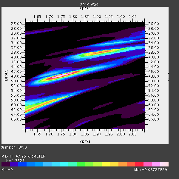
| Thickness Estimate: | 47 km |
| Thickness StdDev: | 4.5 km |
| Vp/Vs Estimate: | 1.75 |
| Vp/Vs StdDev: | 0.09 |
| Vs Estimate: | 3.746 km/s |
| Poisson's Ratio: | 0.26 |
| Peak Value: | 0.09 |
| Assumed Vp: | 6.565 km/s |
| Ps Weight: | 0.33333334 |
| PpPs Weight: | 0.33333334 |
| PsPs Weight: | 0.33333328 |
| Residual Complexity: | 0.740 |
| Nearby stations H: | +- |
| (2.0 deg) Vp/Vs: | +- |
1 with match > 90% ( 3.7037036 %) and 2 with match > 80% ( 7.4074073 %) out of 27.
Download stack as xyz text file.
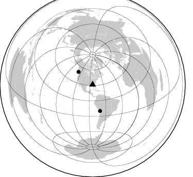
Azimuth Distribution of Events:
Prior Results for this Station
| Study | Thickness | Vp/Vs | Vp | Vs | Poissons Ratio | Extra |
| EARS | 47 km | 1.75 | 6.565 km/s | 3.746 km/s | 0.26 | |
| Crust2.0 | 31 km | 1.78 | 6.565 km/s | 3.684 km/s | 0.27 | DG,thin Platform 1 km seds. |
| Global Maxima | 47 km | 1.75 | 6.565 km/s | 3.746 km/s | 0.26 | amp=0.08726829 |
| Local Maxima 1 | 38 km | 1.91 | 6.565 km/s | 3.432 km/s | 0.31 | amp=0.06696963 |
| Local Maxima 2 | 59 km | 1.69 | 6.565 km/s | 3.879 km/s | 0.23 | amp=0.065310374 |
| Local Maxima 3 | 62 km | 1.60 | 6.565 km/s | 4.103 km/s | 0.18 | amp=0.05546353 |
| Local Maxima 4 | 34 km | 1.98 | 6.565 km/s | 3.324 km/s | 0.33 | amp=0.02851009 |
| Predicted Arrivals for vertical incidence (zero ray parameter) | |
| Ps | 5.42 SECOND |
| PpPs | 19.81 SECOND |
| PsPs/PpSs | 25.23 SECOND |
Events Processed for this Station
Download zip of receiver functions as SAC
Plot maxima for each earthquake.
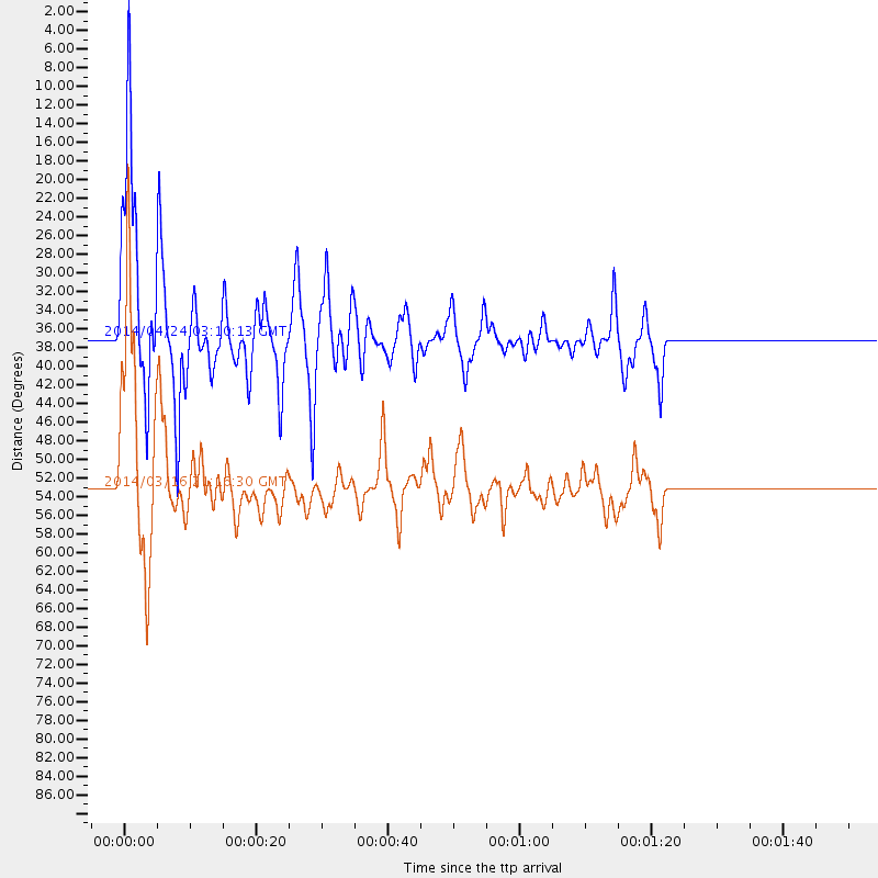
Events Used in the Stack
(2 events)| Radial Match | Distance | Baz | FERegion | Time | Lat/Lon | Depth | Magnitude |
| 92.34535 | 53.0 deg | 164.307 deg | Near Coast Of Northern Chile | 2014/03/16 21:16:30 GMT | (-19.9, -70.6) | 20 km | 6.7 MWW, 6.7 MWC, 7.0 MI |
| 86.66357 | 36.9 deg | 312.096 deg | Vancouver Island, Canada Region | 2014/04/24 03:10:13 GMT | (49.8, -127.4) | 11 km | 6.7 MWP, 6.7 MI |
Losers
(25 events)| Radial Match | Distance | Baz | FERegion | Time | Lat/Lon | Depth | Magnitude | Reason |
| 97.79196 | 52.7 deg | 164.438 deg | Near Coast Of Northern Chile | 2014/04/01 23:46:46 GMT | (-19.6, -70.8) | 20 km | 8.2 MWW, 8.0 MI, 8.1 MWC | |
| 93.714485 | 53.6 deg | 164.34 deg | Near Coast Of Northern Chile | 2014/04/03 02:43:14 GMT | (-20.5, -70.5) | 31 km | 7.7 MWW, 7.4 MI, 7.7 MWC | |
| 89.97988 | 34.2 deg | 297.033 deg | Off Coast Of Northern California | 2014/03/10 05:18:13 GMT | (40.8, -125.1) | 17 km | 6.8 MW, 6.8 MWR, 6.9 MWW, 6.9 MWB, 7.0 MI, 7.0 MWC | |
| 88.5377 | 52.8 deg | 164.54 deg | Near Coast Of Northern Chile | 2014/03/22 12:59:59 GMT | (-19.8, -70.9) | 20 km | 6.2 MWW, 6.2 MWB, 6.3 MWC, 6.4 MWC | |
| 87.607124 | 37.3 deg | 175.163 deg | Near Coast Of Northern Peru | 2014/03/15 23:51:33 GMT | (-5.6, -81.0) | 29 km | 6.3 MWW, 6.2 MWB, 6.3 MWC | |
| 83.78513 | 53.3 deg | 164.33 deg | Near Coast Of Northern Chile | 2014/04/03 01:58:31 GMT | (-20.3, -70.6) | 23 km | 6.5 MWW, 6.5 MWB, 6.6 MWC | |
| 82.577225 | 53.6 deg | 164.644 deg | Near Coast Of Northern Chile | 2014/04/04 01:37:51 GMT | (-20.6, -70.7) | 20 km | 6.1 MWP, 6.1 MWB, 6.1 MWW, 6.3 MWC | |
| 78.663605 | 52.8 deg | 164.462 deg | Near Coast Of Northern Chile | 2014/03/23 18:20:03 GMT | (-19.7, -70.8) | 35 km | 6.0 MB, 6.2 MWB, 6.2 MWW, 6.3 MWC | |
| 64.143074 | 46.4 deg | 168.855 deg | Near Coast Of Peru | 2014/02/18 23:35:58 GMT | (-14.2, -75.6) | 57 km | 6.0 MWB, 5.9 MWW, 5.9 MWC, 6.0 MWC | |
| 63.80203 | 80.9 deg | 50.583 deg | Greece | 2014/02/03 03:08:46 GMT | (38.3, 20.4) | 5.0 km | 6.0 MWW, 6.0 MWB, 6.1 MWC | |
| 62.6709 | 46.2 deg | 169.776 deg | Near Coast Of Peru | 2014/03/15 08:59:21 GMT | (-14.1, -76.3) | 20 km | 6.1 MWW, 6.0 MWB, 6.2 MWC | |
| 60.414444 | 54.3 deg | 156.569 deg | Southern Bolivia | 2014/01/27 16:42:37 GMT | (-19.3, -63.9) | 600 km | 5.6 MWB | |
| 58.394543 | 65.3 deg | 168.594 deg | Near Coast Of Central Chile | 2014/04/05 02:22:38 GMT | (-32.8, -71.6) | 40 km | 5.6 MWC, 5.6 MWC | |
| 58.020927 | 53.2 deg | 164.631 deg | Near Coast Of Northern Chile | 2014/04/02 04:46:18 GMT | (-20.2, -70.9) | 10 km | 5.8 MB | |
| 57.986675 | 41.9 deg | 214.328 deg | Central East Pacific Rise | 2014/01/07 23:02:53 GMT | (-4.5, -106.1) | 10 km | 5.7 MWB, 5.8 MWC | |
| 55.369183 | 68.8 deg | 191.06 deg | West Chile Rise | 2014/05/06 20:52:29 GMT | (-36.3, -96.7) | 14 km | 5.9 MWB | |
| 51.483284 | 77.5 deg | 174.476 deg | Off Coast Of Southern Chile | 2014/03/02 17:03:43 GMT | (-45.8, -76.2) | 10 km | 5.4 MW | |
| 50.34547 | 52.3 deg | 323.84 deg | Southern Alaska | 2014/05/10 14:16:08 GMT | (60.0, -152.2) | 96 km | 5.8 ML, 5.5 MI, 5.7 MWP | |
| 49.118935 | 53.4 deg | 164.835 deg | Near Coast Of Northern Chile | 2014/04/06 14:06:09 GMT | (-20.4, -71.0) | 20 km | 5.3 MW | |
| 47.82194 | 53.6 deg | 164.589 deg | Near Coast Of Northern Chile | 2014/04/03 09:23:21 GMT | (-20.6, -70.7) | 15 km | 5.6 MB, 5.3 MWR | |
| 44.830696 | 57.3 deg | 163.989 deg | Northern Chile | 2014/03/20 18:41:32 GMT | (-24.0, -69.2) | 96 km | 5.1 MW | |
| 44.709217 | 53.6 deg | 164.636 deg | Near Coast Of Northern Chile | 2014/04/13 12:11:30 GMT | (-20.6, -70.7) | 13 km | 5.5 MWW, 5.3 MWR | |
| 42.42403 | 77.6 deg | 174.779 deg | Off Coast Of Southern Chile | 2014/03/02 16:18:30 GMT | (-45.9, -76.6) | 23 km | 5.0 MW | |
| 41.990734 | 63.9 deg | 318.469 deg | Fox Islands, Aleutian Islands | 2014/02/26 21:13:40 GMT | (53.6, -171.8) | 265 km | 6.1 MWW, 5.9 MI, 5.9 ML, 6.1 MWC, 6.1 MWB, 6.2 MWC | |
| 40.1926 | 52.7 deg | 164.058 deg | Near Coast Of Northern Chile | 2014/04/02 00:04:54 GMT | (-19.6, -70.5) | 34 km | 5.5 MB |

