
Station Z9 W10N - McCay Farm, Cordele, GA
Network: Z910 - Southeastern Suture of the Appalachian Margin Experiment
Nearby stations (2 deg radius)
| Station | Name | (Lat, Lon) | Start / End | Elevation |
| W10N | McCay Farm, Cordele, GA | (31.90, -83.89) | 2013-10-19 / 2014-05-13 | 885 m |
| Crust2 Type: | DG,thin Platform 1 km seds. |
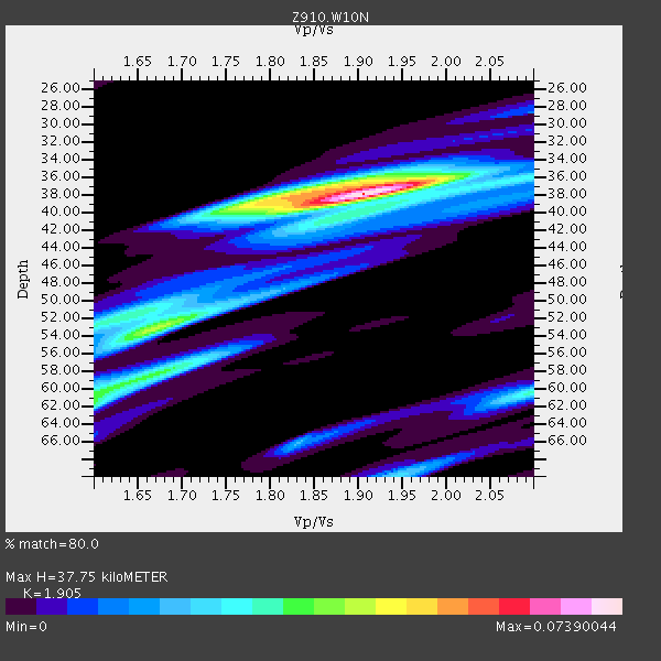
| Thickness Estimate: | 38 km |
| Thickness StdDev: | 6.4 km |
| Vp/Vs Estimate: | 1.90 |
| Vp/Vs StdDev: | 0.10 |
| Vs Estimate: | 3.446 km/s |
| Poisson's Ratio: | 0.31 |
| Peak Value: | 0.07 |
| Assumed Vp: | 6.565 km/s |
| Ps Weight: | 0.33333334 |
| PpPs Weight: | 0.33333334 |
| PsPs Weight: | 0.33333328 |
| Residual Complexity: | 0.612 |
| Nearby stations H: | +- |
| (2.0 deg) Vp/Vs: | +- |
1 with match > 90% ( 3.8461537 %) and 2 with match > 80% ( 7.6923075 %) out of 26.
Download stack as xyz text file.
Azimuth Distribution of Events:

Prior Results for this Station
| Study | Thickness | Vp/Vs | Vp | Vs | Poissons Ratio | Extra |
| EARS | 38 km | 1.90 | 6.565 km/s | 3.446 km/s | 0.31 | |
| Crust2.0 | 31 km | 1.78 | 6.565 km/s | 3.684 km/s | 0.27 | DG,thin Platform 1 km seds. |
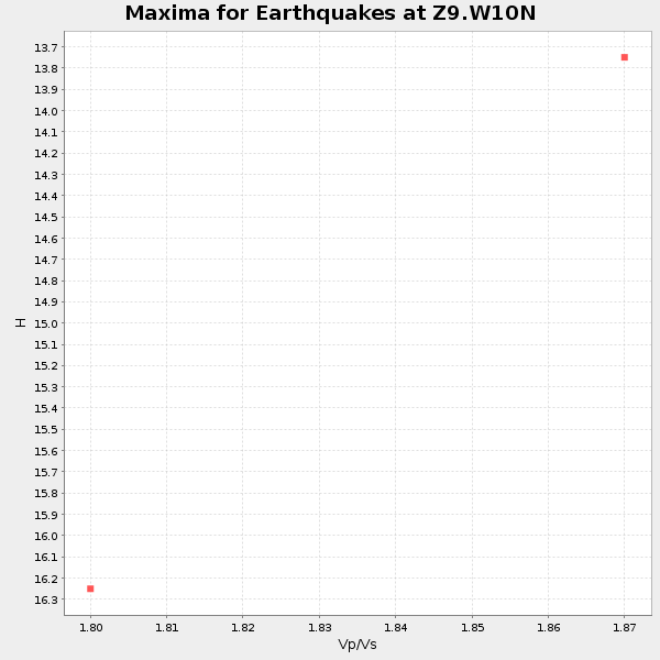
| Global Maxima | 38 km | 1.90 | 6.565 km/s | 3.446 km/s | 0.31 | amp=0.07390044 |
| Local Maxima 1 | 53 km | 1.67 | 6.565 km/s | 3.931 km/s | 0.22 | amp=0.040788855 |
| Local Maxima 2 | 38 km | 1.84 | 6.565 km/s | 3.573 km/s | 0.29 | amp=0.036649913 |
| Local Maxima 3 | 58 km | 1.68 | 6.565 km/s | 3.919 km/s | 0.22 | amp=0.032708198 |
| Local Maxima 4 | 60 km | 2.10 | 6.565 km/s | 3.13 km/s | 0.35 | amp=0.0314202 |
| Predicted Arrivals for vertical incidence (zero ray parameter) | |
| Ps | 5.20 SECOND |
| PpPs | 16.71 SECOND |
| PsPs/PpSs | 21.91 SECOND |
Events Processed for this Station
Download zip of receiver functions as SAC
Plot maxima for each earthquake.
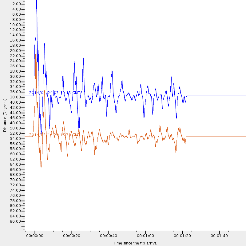
Events Used in the Stack
(2 events)| Radial Match | Distance | Baz | FERegion | Time | Lat/Lon | Depth | Magnitude |
| 93.69645 | 53.1 deg | 164.332 deg | Near Coast Of Northern Chile | 2014/03/16 21:16:30 GMT | (-19.9, -70.6) | 20 km | 6.7 MWW, 6.7 MWC, 7.0 MI |
| 88.07602 | 36.9 deg | 311.999 deg | Vancouver Island, Canada Region | 2014/04/24 03:10:13 GMT | (49.8, -127.4) | 11 km | 6.7 MWP, 6.7 MI |
Losers
(24 events)| Radial Match | Distance | Baz | FERegion | Time | Lat/Lon | Depth | Magnitude | Reason |
| 98.205345 | 52.8 deg | 164.463 deg | Near Coast Of Northern Chile | 2014/04/01 23:46:46 GMT | (-19.6, -70.8) | 20 km | 8.2 MWW, 8.0 MI, 8.1 MWC | |
| 95.50987 | 53.7 deg | 164.364 deg | Near Coast Of Northern Chile | 2014/04/03 02:43:14 GMT | (-20.5, -70.5) | 31 km | 7.7 MWW, 7.4 MI, 7.7 MWC | |
| 91.30449 | 52.8 deg | 163.67 deg | Near Coast Of Northern Chile | 2014/04/01 23:59:57 GMT | (-19.5, -70.2) | 22 km | 5.8 MB | |
| 90.37191 | 34.1 deg | 296.906 deg | Off Coast Of Northern California | 2014/03/10 05:18:13 GMT | (40.8, -125.1) | 17 km | 6.8 MW, 6.8 MWR, 6.9 MWW, 6.9 MWB, 7.0 MI, 7.0 MWC | |
| 89.20578 | 52.7 deg | 164.449 deg | Near Coast Of Northern Chile | 2014/04/02 00:06:44 GMT | (-19.6, -70.8) | 10 km | 5.7 MB | |
| 88.60318 | 53.4 deg | 164.354 deg | Near Coast Of Northern Chile | 2014/04/03 01:58:31 GMT | (-20.3, -70.6) | 23 km | 6.5 MWW, 6.5 MWB, 6.6 MWC | |
| 85.18428 | 53.7 deg | 164.668 deg | Near Coast Of Northern Chile | 2014/04/04 01:37:51 GMT | (-20.6, -70.7) | 20 km | 6.1 MWP, 6.1 MWB, 6.1 MWW, 6.3 MWC | |
| 84.87154 | 52.9 deg | 164.565 deg | Near Coast Of Northern Chile | 2014/03/22 12:59:59 GMT | (-19.8, -70.9) | 20 km | 6.2 MWW, 6.2 MWB, 6.3 MWC, 6.4 MWC | |
| 77.58867 | 52.9 deg | 164.487 deg | Near Coast Of Northern Chile | 2014/03/23 18:20:03 GMT | (-19.7, -70.8) | 35 km | 6.0 MB, 6.2 MWB, 6.2 MWW, 6.3 MWC | |
| 68.36275 | 46.5 deg | 168.878 deg | Near Coast Of Peru | 2014/02/18 23:35:58 GMT | (-14.2, -75.6) | 57 km | 6.0 MWB, 5.9 MWW, 5.9 MWC, 6.0 MWC | |
| 65.57345 | 52.2 deg | 323.796 deg | Southern Alaska | 2014/05/10 14:16:08 GMT | (60.0, -152.2) | 96 km | 5.8 ML, 5.5 MI, 5.7 MWP | |
| 65.05978 | 54.4 deg | 156.602 deg | Southern Bolivia | 2014/01/27 16:42:37 GMT | (-19.3, -63.9) | 600 km | 5.6 MWB | |
| 63.785755 | 53.1 deg | 164.52 deg | Near Coast Of Northern Chile | 2014/03/18 21:26:45 GMT | (-20.0, -70.8) | 3.8 km | 5.8 MWW, 5.9 MWC, 6.0 MWR, 6.0 MWB | |
| 62.288303 | 53.7 deg | 164.613 deg | Near Coast Of Northern Chile | 2014/04/03 09:23:21 GMT | (-20.6, -70.7) | 15 km | 5.6 MB, 5.3 MWR | |
| 62.250504 | 67.3 deg | 169.204 deg | Near Coast Of Central Chile | 2014/03/15 14:46:28 GMT | (-34.7, -71.8) | 45 km | 5.5 MB, 5.1 MWW | |
| 61.79415 | 36.8 deg | 77.656 deg | Northern Mid-Atlantic Ridge | 2014/03/01 02:16:39 GMT | (32.2, -40.3) | 14 km | 5.2 MW | |
| 61.653385 | 68.9 deg | 191.056 deg | West Chile Rise | 2014/05/06 20:52:29 GMT | (-36.3, -96.7) | 14 km | 5.9 MWB | |
| 55.040203 | 46.3 deg | 169.798 deg | Near Coast Of Peru | 2014/03/15 08:59:21 GMT | (-14.1, -76.3) | 20 km | 6.1 MWW, 6.0 MWB, 6.2 MWC | |
| 54.836227 | 66.1 deg | 169.119 deg | Near Coast Of Central Chile | 2014/03/04 10:51:15 GMT | (-33.6, -72.0) | 20 km | 5.7 MWW, 5.7 MWB, 5.8 MWC | |
| 53.877823 | 53.2 deg | 164.656 deg | Near Coast Of Northern Chile | 2014/04/02 04:46:18 GMT | (-20.2, -70.9) | 10 km | 5.8 MB | |
| 49.809174 | 63.9 deg | 318.438 deg | Fox Islands, Aleutian Islands | 2014/02/26 21:13:40 GMT | (53.6, -171.8) | 265 km | 6.1 MWW, 5.9 MI, 5.9 ML, 6.1 MWC, 6.1 MWB, 6.2 MWC | |
| 49.35362 | 52.8 deg | 164.698 deg | Near Coast Of Northern Chile | 2014/03/22 22:14:57 GMT | (-19.7, -71.0) | 19 km | 5.1 MW | |
| 48.721645 | 53.3 deg | 164.531 deg | Near Coast Of Northern Chile | 2014/05/05 11:21:19 GMT | (-20.2, -70.7) | 24 km | 5.4 MW | |
| 46.21865 | 53.0 deg | 164.439 deg | Near Coast Of Northern Chile | 2014/04/02 00:24:45 GMT | (-19.9, -70.7) | 10 km | 5.6 MB |

