
Station Z9 W13 - Coley Farm, Vienna, GA
Network: Z910 - Southeastern Suture of the Appalachian Margin Experiment
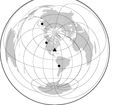
Nearby stations (2 deg radius)

| Station | Name | (Lat, Lon) | Start / End | Elevation |
| W13 | Coley Farm, Vienna, GA | (32.06, -83.89) | 2011-05-16 / 2014-05-14 | 107 m |
| Crust2 Type: | DG,thin Platform 1 km seds. |
| Thickness Estimate: | 31 km |
| Thickness StdDev: | 1.1 km |
| Vp/Vs Estimate: | 2.01 |
| Vp/Vs StdDev: | 0.08 |
| Vs Estimate: | 3.266 km/s |
| Poisson's Ratio: | 0.34 |
| Peak Value: | 0.07 |
| Assumed Vp: | 6.565 km/s |
| Ps Weight: | 0.33333334 |
| PpPs Weight: | 0.33333334 |
| PsPs Weight: | 0.33333328 |
| Residual Complexity: | 0.513 |
| Nearby stations H: | +- |
| (2.0 deg) Vp/Vs: | +- |
1 with match > 90% ( 4.0 %) and 4 with match > 80% ( 16.0 %) out of 25.
Download stack as xyz text file.
Azimuth Distribution of Events:
Prior Results for this Station
| Study | Thickness | Vp/Vs | Vp | Vs | Poissons Ratio | Extra |
| EARS | 31 km | 2.01 | 6.565 km/s | 3.266 km/s | 0.34 | |
| Crust2.0 | 31 km | 1.78 | 6.565 km/s | 3.684 km/s | 0.27 | DG,thin Platform 1 km seds. |
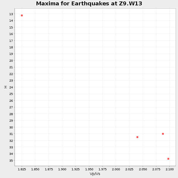
| Global Maxima | 31 km | 2.01 | 6.565 km/s | 3.266 km/s | 0.34 | amp=0.07287123 |
| Local Maxima 1 | 60 km | 2.04 | 6.565 km/s | 3.226 km/s | 0.34 | amp=0.03778247 |
| Local Maxima 2 | 33 km | 1.85 | 6.565 km/s | 3.548 km/s | 0.29 | amp=0.03155072 |
| Local Maxima 3 | 29 km | 2.09 | 6.565 km/s | 3.137 km/s | 0.35 | amp=0.022642748 |
| Local Maxima 4 | 45 km | 1.81 | 6.565 km/s | 3.637 km/s | 0.28 | amp=0.020578897 |
| Predicted Arrivals for vertical incidence (zero ray parameter) | |
| Ps | 4.81 SECOND |
| PpPs | 14.33 SECOND |
| PsPs/PpSs | 19.14 SECOND |
Events Processed for this Station
Download zip of receiver functions as SAC
Plot maxima for each earthquake.
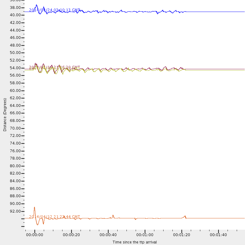
Events Used in the Stack
(4 events)| Radial Match | Distance | Baz | FERegion | Time | Lat/Lon | Depth | Magnitude |
| 92.6677 | 53.2 deg | 164.363 deg | Near Coast Of Northern Chile | 2014/03/16 21:16:30 GMT | (-19.9, -70.6) | 20 km | 6.7 MWW, 6.7 MWC, 7.0 MI |
| 87.18657 | 96.1 deg | 334.15 deg | E. Russia-N.E. China Border Reg. | 2014/04/12 21:22:44 GMT | (44.9, 133.7) | 10 km | 4.3 mb |
| 87.01367 | 36.8 deg | 311.847 deg | Vancouver Island, Canada Region | 2014/04/24 03:10:13 GMT | (49.8, -127.4) | 11 km | 6.7 MWP, 6.7 MI |
| 81.856415 | 53.6 deg | 164.385 deg | Near Coast Of Northern Chile | 2014/04/03 01:58:31 GMT | (-20.3, -70.6) | 23 km | 6.5 MWW, 6.5 MWB, 6.6 MWC |
Losers
(21 events)| Radial Match | Distance | Baz | FERegion | Time | Lat/Lon | Depth | Magnitude | Reason |
| 95.900955 | 53.8 deg | 164.395 deg | Near Coast Of Northern Chile | 2014/04/03 02:43:14 GMT | (-20.5, -70.5) | 31 km | 7.7 MWW, 7.4 MI, 7.7 MWC | |
| 94.14727 | 52.9 deg | 164.494 deg | Near Coast Of Northern Chile | 2014/04/01 23:46:46 GMT | (-19.6, -70.8) | 20 km | 8.2 MWW, 8.0 MI, 8.1 MWC | |
| 89.311455 | 53.0 deg | 164.596 deg | Near Coast Of Northern Chile | 2014/03/22 12:59:59 GMT | (-19.8, -70.9) | 20 km | 6.2 MWW, 6.2 MWB, 6.3 MWC, 6.4 MWC | |
| 88.842735 | 34.1 deg | 296.705 deg | Off Coast Of Northern California | 2014/03/10 05:18:13 GMT | (40.8, -125.1) | 17 km | 6.8 MW, 6.8 MWR, 6.9 MWW, 6.9 MWB, 7.0 MI, 7.0 MWC | |
| 87.72158 | 52.9 deg | 163.703 deg | Near Coast Of Northern Chile | 2014/04/01 23:59:57 GMT | (-19.5, -70.2) | 22 km | 5.8 MB | |
| 85.62252 | 53.9 deg | 164.697 deg | Near Coast Of Northern Chile | 2014/04/04 01:37:51 GMT | (-20.6, -70.7) | 20 km | 6.1 MWP, 6.1 MWB, 6.1 MWW, 6.3 MWC | |
| 84.08277 | 37.5 deg | 175.198 deg | Near Coast Of Northern Peru | 2014/03/15 23:51:33 GMT | (-5.6, -81.0) | 29 km | 6.3 MWW, 6.2 MWB, 6.3 MWC | |
| 72.46589 | 46.5 deg | 169.824 deg | Near Coast Of Peru | 2014/03/15 08:59:21 GMT | (-14.1, -76.3) | 20 km | 6.1 MWW, 6.0 MWB, 6.2 MWC | |
| 71.66108 | 68.7 deg | 50.121 deg | France | 2014/04/07 19:27:00 GMT | (44.5, 6.7) | 9.1 km | 5.0 MW | |
| 71.013916 | 52.1 deg | 323.726 deg | Southern Alaska | 2014/05/10 14:16:08 GMT | (60.0, -152.2) | 96 km | 5.8 ML, 5.5 MI, 5.7 MWP | |
| 69.98338 | 53.0 deg | 164.518 deg | Near Coast Of Northern Chile | 2014/03/23 18:20:03 GMT | (-19.7, -70.8) | 35 km | 6.0 MB, 6.2 MWB, 6.2 MWW, 6.3 MWC | |
| 67.59725 | 46.6 deg | 168.906 deg | Near Coast Of Peru | 2014/02/18 23:35:58 GMT | (-14.2, -75.6) | 57 km | 6.0 MWB, 5.9 MWW, 5.9 MWC, 6.0 MWC | |
| 64.49724 | 63.7 deg | 318.388 deg | Fox Islands, Aleutian Islands | 2014/02/26 21:13:40 GMT | (53.6, -171.8) | 265 km | 6.1 MWW, 5.9 MI, 5.9 ML, 6.1 MWC, 6.1 MWB, 6.2 MWC | |
| 57.718582 | 36.7 deg | 77.855 deg | Northern Mid-Atlantic Ridge | 2014/03/01 02:16:39 GMT | (32.2, -40.3) | 14 km | 5.2 MW | |
| 51.736893 | 54.5 deg | 156.645 deg | Southern Bolivia | 2014/01/27 16:42:37 GMT | (-19.3, -63.9) | 600 km | 5.6 MWB | |
| 50.06824 | 65.5 deg | 168.621 deg | Near Coast Of Central Chile | 2014/04/05 02:22:38 GMT | (-32.8, -71.6) | 40 km | 5.6 MWC, 5.6 MWC | |
| 50.010757 | 53.3 deg | 164.481 deg | Near Coast Of Northern Chile | 2014/03/17 00:12:11 GMT | (-20.0, -70.7) | 19 km | 5.1 mb | |
| 48.94947 | 83.9 deg | 329.076 deg | Sea Of Okhotsk | 2014/01/15 06:55:09 GMT | (51.5, 151.0) | 551 km | 4.6 mb | |
| 42.54425 | 56.4 deg | 333.245 deg | Northern Alaska | 2014/05/03 08:57:12 GMT | (67.6, -162.2) | 0.9 km | 5.5 MB | |
| 40.661568 | 53.4 deg | 164.686 deg | Near Coast Of Northern Chile | 2014/04/02 04:46:18 GMT | (-20.2, -70.9) | 10 km | 5.8 MB | |
| 29.894278 | 53.7 deg | 164.448 deg | Near Coast Of Northern Chile | 2014/04/02 19:45:49 GMT | (-20.4, -70.6) | 17 km | 5.3 MW |

