
Station Z9 W14 - Coley Farm, Vienna, GA
Network: Z910 - Southeastern Suture of the Appalachian Margin Experiment
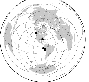
Nearby stations (2 deg radius)
| Station | Name | (Lat, Lon) | Start / End | Elevation |
| W14 | Coley Farm, Vienna, GA | (32.09, -83.90) | 2010-07-18 / 2014-12-31 | 97 m |
| Crust2 Type: | DG,thin Platform 1 km seds. |
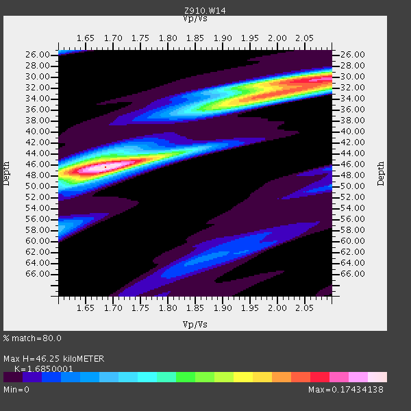
| Thickness Estimate: | 46 km |
| Thickness StdDev: | 6.2 km |
| Vp/Vs Estimate: | 1.69 |
| Vp/Vs StdDev: | 0.16 |
| Vs Estimate: | 3.896 km/s |
| Poisson's Ratio: | 0.23 |
| Peak Value: | 0.17 |
| Assumed Vp: | 6.565 km/s |
| Ps Weight: | 0.33333334 |
| PpPs Weight: | 0.33333334 |
| PsPs Weight: | 0.33333328 |
| Residual Complexity: | 0.754 |
| Nearby stations H: | +- |
| (2.0 deg) Vp/Vs: | +- |
1 with match > 90% ( 5.0 %) and 4 with match > 80% ( 20.0 %) out of 20.
Download stack as xyz text file.
Azimuth Distribution of Events:
Prior Results for this Station
| Study | Thickness | Vp/Vs | Vp | Vs | Poissons Ratio | Extra |
| EARS | 46 km | 1.69 | 6.565 km/s | 3.896 km/s | 0.23 | |
| Crust2.0 | 31 km | 1.78 | 6.565 km/s | 3.684 km/s | 0.27 | DG,thin Platform 1 km seds. |
| Global Maxima | 46 km | 1.69 | 6.565 km/s | 3.896 km/s | 0.23 | amp=0.17434138 |
| Local Maxima 1 | 30 km | 2.09 | 6.565 km/s | 3.137 km/s | 0.35 | amp=0.14836416 |
| Local Maxima 2 | 33 km | 1.97 | 6.565 km/s | 3.328 km/s | 0.33 | amp=0.10378153 |
| Local Maxima 3 | 46 km | 1.64 | 6.565 km/s | 4.009 km/s | 0.20 | amp=0.079665266 |
| Local Maxima 4 | 48 km | 1.66 | 6.565 km/s | 3.943 km/s | 0.22 | amp=0.055146843 |
| Predicted Arrivals for vertical incidence (zero ray parameter) | |
| Ps | 4.83 SECOND |
| PpPs | 18.92 SECOND |
| PsPs/PpSs | 23.74 SECOND |
Events Processed for this Station
Download zip of receiver functions as SAC
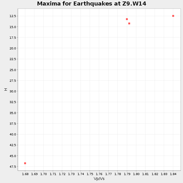
Plot maxima for each earthquake.
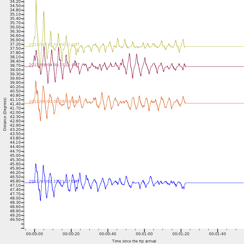
Events Used in the Stack
(4 events)| Radial Match | Distance | Baz | FERegion | Time | Lat/Lon | Depth | Magnitude |
| 90.8109 | 41.3 deg | 165.468 deg | Peru-Brazil Border Region | 2012/08/02 09:38:30 GMT | (-8.4, -74.3) | 145 km | 5.9 MB, 6.1 MW, 6.1 MW |
| 87.13093 | 37.3 deg | 176.761 deg | Near Coast Of Northern Peru | 2013/08/12 09:49:32 GMT | (-5.4, -81.9) | 10 km | 6.2 MWW, 6.1 MWB, 6.2 MWW, 6.2 MWC, 6.3 MWC |
| 86.89108 | 46.9 deg | 168.961 deg | Near Coast Of Peru | 2012/07/02 23:31:37 GMT | (-14.4, -75.6) | 40 km | 6.0 MB, 5.2 MS, 5.7 MW, 5.6 MW |
| 81.47835 | 38.8 deg | 313.353 deg | Queen Charlotte Islands Region | 2013/09/04 00:23:11 GMT | (51.2, -130.2) | 9.9 km | 6.0 MW, 5.9 MI, 5.9 MWR, 6.0 MWW, 6.0 MWW, 6.0 MWC |
Losers
(16 events)| Radial Match | Distance | Baz | FERegion | Time | Lat/Lon | Depth | Magnitude | Reason |
| 78.887886 | 68.1 deg | 317.913 deg | Andreanof Islands, Aleutian Is. | 2012/09/26 23:39:55 GMT | (51.6, -178.3) | 16 km | 6.3 MB, 6.5 MS, 6.4 MW, 6.4 MW | |
| 73.76843 | 66.4 deg | 317.041 deg | Andreanof Islands, Aleutian Is. | 2013/08/30 16:25:02 GMT | (51.5, -175.2) | 29 km | 7.0 MWW, 6.5 ML, 6.8 MI, 6.9 MWC, 6.9 MWB, 7.0 MWW, 7.0 MI, 7.0 MWC | |
| 71.339 | 88.0 deg | 324.704 deg | Kuril Islands | 2012/07/08 11:33:02 GMT | (45.5, 151.3) | 20 km | 5.7 MB, 5.6 MS, 6.0 MW, 5.8 MW | |
| 68.66274 | 39.0 deg | 106.413 deg | Northern Mid-Atlantic Ridge | 2013/09/05 04:01:36 GMT | (15.2, -45.2) | 10 km | 6.0 MWW, 5.9 MWB, 6.0 MWW, 6.0 MWC | |
| 64.488716 | 66.3 deg | 316.664 deg | Andreanof Islands, Aleutian Is. | 2013/08/31 06:38:36 GMT | (51.2, -174.9) | 18 km | 6.0 MWW, 5.5 ML, 5.9 MWB, 5.9 MWC, 6.0 MWC, 6.0 MI, 6.0 MWW | |
| 63.783516 | 66.0 deg | 316.8 deg | Andreanof Islands, Aleutian Is. | 2013/09/05 05:43:39 GMT | (51.5, -174.6) | 20 km | 5.6 MWW, 5.4 MI, 5.5 MWB, 5.6 MWW, 5.7 MWC, 5.7 ML, 5.8 MWC | |
| 63.146275 | 37.1 deg | 308.202 deg | Off Coast Of Washington | 2012/08/19 08:07:35 GMT | (47.8, -128.6) | 10 km | 5.6 MW, 5.3 MS, 5.2 MB, 5.5 MW | |
| 62.01836 | 38.9 deg | 313.414 deg | Queen Charlotte Islands Region | 2013/09/03 20:19:06 GMT | (51.2, -130.4) | 2.7 km | 6.1 MWW, 6.0 MWB, 6.1 MWW, 6.1 MWC, 6.2 MI, 6.2 MWC | |
| 61.658875 | 98.1 deg | 324.32 deg | Off East Coast Of Honshu, Japan | 2011/03/11 08:39:12 GMT | (37.6, 142.8) | 46 km | 5.5 MB | |
| 57.361923 | 82.9 deg | 325.195 deg | Kuril Islands | 2012/07/20 06:32:56 GMT | (49.4, 156.1) | 10 km | 5.8 MB, 5.5 MS, 5.8 MW, 5.9 MW | |
| 49.667213 | 56.0 deg | 162.849 deg | Northern Chile | 2013/08/23 08:34:06 GMT | (-22.3, -68.6) | 111 km | 5.8 MWW, 5.7 MWD, 5.8 MWW, 5.8 MWB, 5.8 MWC | |
| 48.836742 | 36.7 deg | 311.504 deg | Vancouver Island, Canada Region | 2013/08/04 13:22:27 GMT | (49.7, -127.4) | 10 km | 5.6 MB, 5.5 MW | |
| 48.20512 | 66.1 deg | 316.82 deg | Andreanof Islands, Aleutian Is. | 2013/09/04 04:16:30 GMT | (51.4, -174.7) | 27 km | 5.9 MW, 5.2 ML, 5.4 ML, 5.8 MWW, 5.8 MWW, 5.9 MWC | |
| 42.475834 | 53.2 deg | 319.869 deg | Kodiak Island Region, Alaska | 2012/09/18 01:44:50 GMT | (56.9, -154.1) | 39 km | 5.5 MB, 4.7 MS, 5.2 MW, 5.1 MW | |
| 41.840122 | 66.2 deg | 316.981 deg | Andreanof Islands, Aleutian Is. | 2013/09/04 06:27:03 GMT | (51.6, -174.9) | 17 km | 6.0 MWW, 5.5 ML, 5.9 MWB, 6.0 MWW, 6.1 MWC, 6.1 MI | |
| 38.10068 | 82.6 deg | 325.258 deg | Kuril Islands | 2012/10/16 12:41:25 GMT | (49.6, 156.4) | 81 km | 6.2 MB, 5.6 MW, 5.6 MW |
