
Station Z9 W14N - Coley Farm, Vienna, GA
Network: Z910 - Southeastern Suture of the Appalachian Margin Experiment
Nearby stations (2 deg radius)
| Station | Name | (Lat, Lon) | Start / End | Elevation |
| W14N | Coley Farm, Vienna, GA | (32.09, -83.90) | 2013-10-18 / 2014-05-15 | 966 m |
| Crust2 Type: | DG,thin Platform 1 km seds. |
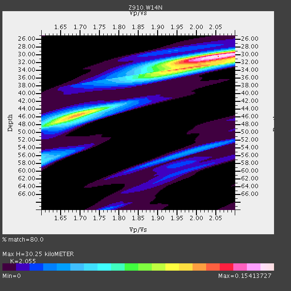
| Thickness Estimate: | 30 km |
| Thickness StdDev: | 6.4 km |
| Vp/Vs Estimate: | 2.06 |
| Vp/Vs StdDev: | 0.15 |
| Vs Estimate: | 3.194 km/s |
| Poisson's Ratio: | 0.34 |
| Peak Value: | 0.15 |
| Assumed Vp: | 6.565 km/s |
| Ps Weight: | 0.33333334 |
| PpPs Weight: | 0.33333334 |
| PsPs Weight: | 0.33333328 |
| Residual Complexity: | 0.643 |
| Nearby stations H: | 45 km +- 1.4 km |
| (2.0 deg) Vp/Vs: | 1.71 +- 0.02 |
1 with match > 90% ( 4.0 %) and 3 with match > 80% ( 12.0 %) out of 25.
Download stack as xyz text file.
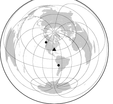
Azimuth Distribution of Events:
Prior Results for this Station
| Study | Thickness | Vp/Vs | Vp | Vs | Poissons Ratio | Extra |
| EARS | 30 km | 2.06 | 6.565 km/s | 3.194 km/s | 0.34 | |
| Crust2.0 | 31 km | 1.78 | 6.565 km/s | 3.684 km/s | 0.27 | DG,thin Platform 1 km seds. |
| Global Maxima | 30 km | 2.06 | 6.565 km/s | 3.194 km/s | 0.34 | amp=0.15413727 |
| Local Maxima 1 | 46 km | 1.69 | 6.565 km/s | 3.896 km/s | 0.23 | amp=0.10797476 |
| Local Maxima 2 | 34 km | 1.95 | 6.565 km/s | 3.371 km/s | 0.32 | amp=0.09049203 |
| Local Maxima 3 | 57 km | 1.60 | 6.565 km/s | 4.096 km/s | 0.18 | amp=0.05007522 |
| Local Maxima 4 | 31 km | 2.09 | 6.565 km/s | 3.145 km/s | 0.35 | amp=0.039224584 |
| Predicted Arrivals for vertical incidence (zero ray parameter) | |
| Ps | 4.86 SECOND |
| PpPs | 14.08 SECOND |
| PsPs/PpSs | 18.94 SECOND |
Events Processed for this Station
Download zip of receiver functions as SAC
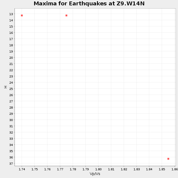
Plot maxima for each earthquake.
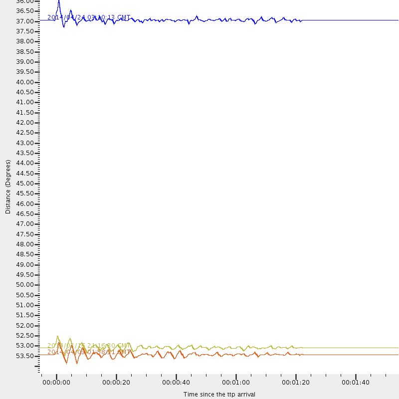
Events Used in the Stack
(3 events)| Radial Match | Distance | Baz | FERegion | Time | Lat/Lon | Depth | Magnitude |
| 93.2818 | 53.3 deg | 164.365 deg | Near Coast Of Northern Chile | 2014/03/16 21:16:30 GMT | (-19.9, -70.6) | 20 km | 6.7 MWW, 6.7 MWC, 7.0 MI |
| 86.432915 | 53.6 deg | 164.387 deg | Near Coast Of Northern Chile | 2014/04/03 01:58:31 GMT | (-20.3, -70.6) | 23 km | 6.5 MWW, 6.5 MWB, 6.6 MWC |
| 83.00482 | 36.7 deg | 311.81 deg | Vancouver Island, Canada Region | 2014/04/24 03:10:13 GMT | (49.8, -127.4) | 11 km | 6.7 MWP, 6.7 MI |
Losers
(22 events)| Radial Match | Distance | Baz | FERegion | Time | Lat/Lon | Depth | Magnitude | Reason |
| 96.27235 | 52.9 deg | 164.496 deg | Near Coast Of Northern Chile | 2014/04/01 23:46:46 GMT | (-19.6, -70.8) | 20 km | 8.2 MWW, 8.0 MI, 8.1 MWC | |
| 95.62516 | 53.9 deg | 164.396 deg | Near Coast Of Northern Chile | 2014/04/03 02:43:14 GMT | (-20.5, -70.5) | 31 km | 7.7 MWW, 7.4 MI, 7.7 MWC | |
| 91.697845 | 34.0 deg | 296.654 deg | Off Coast Of Northern California | 2014/03/10 05:18:13 GMT | (40.8, -125.1) | 17 km | 6.8 MW, 6.8 MWR, 6.9 MWW, 6.9 MWB, 7.0 MI, 7.0 MWC | |
| 89.53203 | 53.0 deg | 163.705 deg | Near Coast Of Northern Chile | 2014/04/01 23:59:57 GMT | (-19.5, -70.2) | 22 km | 5.8 MB | |
| 88.57427 | 53.1 deg | 164.597 deg | Near Coast Of Northern Chile | 2014/03/22 12:59:59 GMT | (-19.8, -70.9) | 20 km | 6.2 MWW, 6.2 MWB, 6.3 MWC, 6.4 MWC | |
| 87.301056 | 37.6 deg | 175.193 deg | Near Coast Of Northern Peru | 2014/03/15 23:51:33 GMT | (-5.6, -81.0) | 29 km | 6.3 MWW, 6.2 MWB, 6.3 MWC | |
| 80.72908 | 53.9 deg | 164.699 deg | Near Coast Of Northern Chile | 2014/04/04 01:37:51 GMT | (-20.6, -70.7) | 20 km | 6.1 MWP, 6.1 MWB, 6.1 MWW, 6.3 MWC | |
| 63.06063 | 53.0 deg | 164.519 deg | Near Coast Of Northern Chile | 2014/03/23 18:20:03 GMT | (-19.7, -70.8) | 35 km | 6.0 MB, 6.2 MWB, 6.2 MWW, 6.3 MWC | |
| 62.718746 | 46.7 deg | 168.906 deg | Near Coast Of Peru | 2014/02/18 23:35:58 GMT | (-14.2, -75.6) | 57 km | 6.0 MWB, 5.9 MWW, 5.9 MWC, 6.0 MWC | |
| 61.662773 | 54.5 deg | 156.65 deg | Southern Bolivia | 2014/01/27 16:42:37 GMT | (-19.3, -63.9) | 600 km | 5.6 MWB | |
| 60.889305 | 52.0 deg | 323.708 deg | Southern Alaska | 2014/05/10 14:16:08 GMT | (60.0, -152.2) | 96 km | 5.8 ML, 5.5 MI, 5.7 MWP | |
| 60.793934 | 53.9 deg | 164.644 deg | Near Coast Of Northern Chile | 2014/04/03 09:23:21 GMT | (-20.6, -70.7) | 15 km | 5.6 MB, 5.3 MWR | |
| 59.550556 | 52.9 deg | 164.484 deg | Near Coast Of Northern Chile | 2014/03/24 15:45:31 GMT | (-19.6, -70.8) | 18 km | 5.6 MWB, 5.5 MWR, 5.7 MWC, 5.7 MWW | |
| 59.245026 | 46.5 deg | 169.824 deg | Near Coast Of Peru | 2014/03/15 08:59:21 GMT | (-14.1, -76.3) | 20 km | 6.1 MWW, 6.0 MWB, 6.2 MWC | |
| 58.126316 | 97.7 deg | 256.703 deg | Tonga Islands | 2014/01/26 10:39:36 GMT | (-15.4, -173.5) | 42 km | 5.5 MW | |
| 54.66943 | 53.4 deg | 164.687 deg | Near Coast Of Northern Chile | 2014/04/02 04:46:18 GMT | (-20.2, -70.9) | 10 km | 5.8 MB | |
| 50.14703 | 83.8 deg | 329.072 deg | Sea Of Okhotsk | 2014/01/15 06:55:09 GMT | (51.5, 151.0) | 551 km | 4.6 mb | |
| 49.61678 | 68.8 deg | 317.761 deg | Andreanof Islands, Aleutian Is. | 2014/01/16 07:33:09 GMT | (51.2, -179.2) | 27 km | 5.5 MWB, 5.2 ML, 5.5 ML, 5.6 MWC | |
| 46.21375 | 53.5 deg | 164.292 deg | Near Coast Of Northern Chile | 2014/04/05 05:44:57 GMT | (-20.1, -70.5) | 39 km | 5.3 MW | |
| 46.154034 | 53.2 deg | 164.766 deg | Near Coast Of Northern Chile | 2014/04/02 11:07:33 GMT | (-20.0, -71.0) | 27 km | 5.4 Mww | |
| 45.105106 | 63.7 deg | 318.374 deg | Fox Islands, Aleutian Islands | 2014/02/26 21:13:40 GMT | (53.6, -171.8) | 265 km | 6.1 MWW, 5.9 MI, 5.9 ML, 6.1 MWC, 6.1 MWB, 6.2 MWC | |
| 43.289097 | 57.5 deg | 164.039 deg | Northern Chile | 2014/03/20 18:41:32 GMT | (-24.0, -69.2) | 96 km | 5.1 MW |

