
Station Z9 W15A - Roney Farm, Vienna, GA
Network: Z910 - Southeastern Suture of the Appalachian Margin Experiment
Nearby stations (2 deg radius)
| Station | Name | (Lat, Lon) | Start / End | Elevation |
| W15A | Roney Farm, Vienna, GA | (32.14, -83.90) | 2010-07-18 / 2014-05-14 | 103 m |
| Crust2 Type: | DG,thin Platform 1 km seds. |
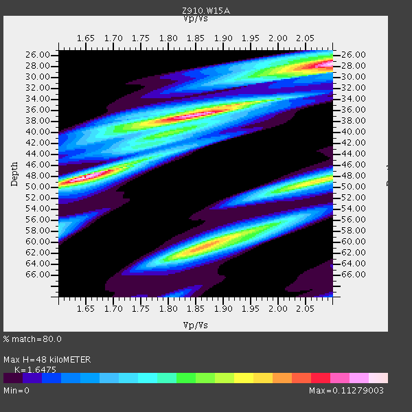
| Thickness Estimate: | 48 km |
| Thickness StdDev: | 9.1 km |
| Vp/Vs Estimate: | 1.65 |
| Vp/Vs StdDev: | 0.16 |
| Vs Estimate: | 3.985 km/s |
| Poisson's Ratio: | 0.21 |
| Peak Value: | 0.11 |
| Assumed Vp: | 6.565 km/s |
| Ps Weight: | 0.33333334 |
| PpPs Weight: | 0.33333334 |
| PsPs Weight: | 0.33333328 |
| Residual Complexity: | 0.889 |
| Nearby stations H: | +- |
| (2.0 deg) Vp/Vs: | +- |
3 with match > 90% ( 12.0 %) and 5 with match > 80% ( 20.0 %) out of 25.
Download stack as xyz text file.
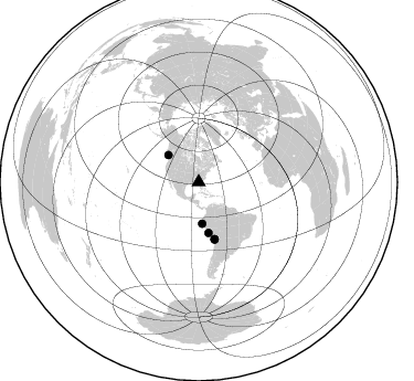
Azimuth Distribution of Events:
Prior Results for this Station
| Study | Thickness | Vp/Vs | Vp | Vs | Poissons Ratio | Extra |
| EARS | 48 km | 1.65 | 6.565 km/s | 3.985 km/s | 0.21 | |
| Crust2.0 | 31 km | 1.78 | 6.565 km/s | 3.684 km/s | 0.27 | DG,thin Platform 1 km seds. |
| Global Maxima | 48 km | 1.65 | 6.565 km/s | 3.985 km/s | 0.21 | amp=0.11279003 |
| Local Maxima 1 | 37 km | 1.84 | 6.565 km/s | 3.563 km/s | 0.29 | amp=0.10292973 |
| Local Maxima 2 | 28 km | 2.10 | 6.565 km/s | 3.13 km/s | 0.35 | amp=0.09794915 |
| Local Maxima 3 | 61 km | 1.86 | 6.565 km/s | 3.525 km/s | 0.30 | amp=0.083279036 |
| Local Maxima 4 | 48 km | 2.10 | 6.565 km/s | 3.133 km/s | 0.35 | amp=0.062476054 |
| Predicted Arrivals for vertical incidence (zero ray parameter) | |
| Ps | 4.73 SECOND |
| PpPs | 19.36 SECOND |
| PsPs/PpSs | 24.09 SECOND |
Events Processed for this Station
Download zip of receiver functions as SAC
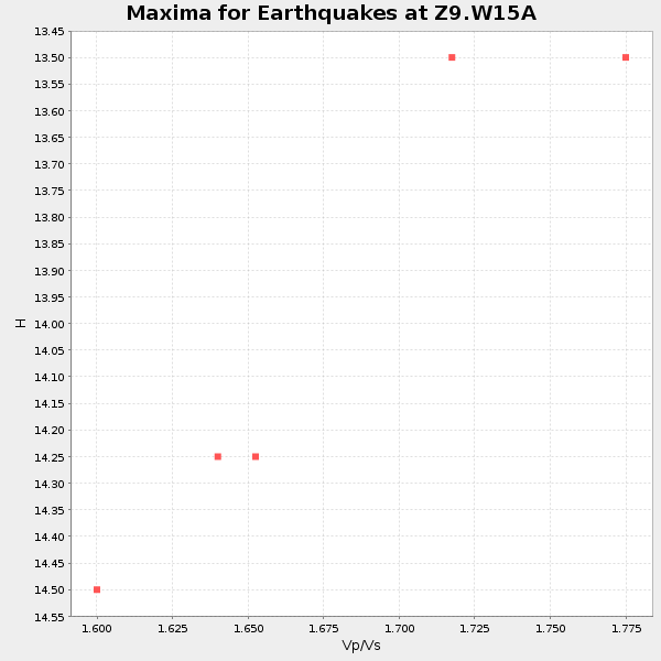
Plot maxima for each earthquake.
Events Used in the Stack
(5 events)| Radial Match | Distance | Baz | FERegion | Time | Lat/Lon | Depth | Magnitude |
| 91.53395 | 36.7 deg | 311.766 deg | Vancouver Island, Canada Region | 2014/04/24 03:10:13 GMT | (49.8, -127.4) | 11 km | 6.7 MWP, 6.7 MI |
| 91.19618 | 37.6 deg | 175.199 deg | Near Coast Of Northern Peru | 2014/03/15 23:51:33 GMT | (-5.6, -81.0) | 29 km | 6.3 MWW, 6.2 MWB, 6.3 MWC |
| 90.80001 | 53.3 deg | 164.374 deg | Near Coast Of Northern Chile | 2014/03/16 21:16:30 GMT | (-19.9, -70.6) | 20 km | 6.7 MWW, 6.7 MWC, 7.0 MI |
| 87.50282 | 53.7 deg | 164.396 deg | Near Coast Of Northern Chile | 2014/04/03 01:58:31 GMT | (-20.3, -70.6) | 23 km | 6.5 MWW, 6.5 MWB, 6.6 MWC |
| 82.842094 | 46.7 deg | 168.915 deg | Near Coast Of Peru | 2014/02/18 23:35:58 GMT | (-14.2, -75.6) | 57 km | 6.0 MWB, 5.9 MWW, 5.9 MWC, 6.0 MWC |
Losers
(20 events)| Radial Match | Distance | Baz | FERegion | Time | Lat/Lon | Depth | Magnitude | Reason |
| 97.57312 | 53.0 deg | 164.505 deg | Near Coast Of Northern Chile | 2014/04/01 23:46:46 GMT | (-19.6, -70.8) | 20 km | 8.2 MWW, 8.0 MI, 8.1 MWC | |
| 95.82558 | 53.9 deg | 164.405 deg | Near Coast Of Northern Chile | 2014/04/03 02:43:14 GMT | (-20.5, -70.5) | 31 km | 7.7 MWW, 7.4 MI, 7.7 MWC | |
| 90.987045 | 34.0 deg | 296.596 deg | Off Coast Of Northern California | 2014/03/10 05:18:13 GMT | (40.8, -125.1) | 17 km | 6.8 MW, 6.8 MWR, 6.9 MWW, 6.9 MWB, 7.0 MI, 7.0 MWC | |
| 89.43249 | 53.0 deg | 163.714 deg | Near Coast Of Northern Chile | 2014/04/01 23:59:57 GMT | (-19.5, -70.2) | 22 km | 5.8 MB | |
| 86.438156 | 53.1 deg | 164.606 deg | Near Coast Of Northern Chile | 2014/03/22 12:59:59 GMT | (-19.8, -70.9) | 20 km | 6.2 MWW, 6.2 MWB, 6.3 MWC, 6.4 MWC | |
| 83.50441 | 54.0 deg | 164.708 deg | Near Coast Of Northern Chile | 2014/04/04 01:37:51 GMT | (-20.6, -70.7) | 20 km | 6.1 MWP, 6.1 MWB, 6.1 MWW, 6.3 MWC | |
| 71.57761 | 53.1 deg | 164.528 deg | Near Coast Of Northern Chile | 2014/03/23 18:20:03 GMT | (-19.7, -70.8) | 35 km | 6.0 MB, 6.2 MWB, 6.2 MWW, 6.3 MWC | |
| 67.84775 | 98.3 deg | 323.517 deg | Off East Coast Of Honshu, Japan | 2014/01/04 05:23:00 GMT | (37.0, 143.4) | 22 km | 5.5 MWB | |
| 63.05464 | 52.0 deg | 323.687 deg | Southern Alaska | 2014/05/10 14:16:08 GMT | (60.0, -152.2) | 96 km | 5.8 ML, 5.5 MI, 5.7 MWP | |
| 62.393513 | 76.4 deg | 176.592 deg | Off Coast Of Southern Chile | 2014/01/07 12:06:13 GMT | (-44.5, -79.3) | 35 km | 5.2 MW | |
| 62.00871 | 95.7 deg | 34.435 deg | Eastern Caucasus | 2014/02/10 12:06:46 GMT | (40.3, 48.8) | 63 km | 5.5 MW | |
| 60.017914 | 80.8 deg | 50.643 deg | Greece | 2014/01/26 13:55:42 GMT | (38.2, 20.5) | 8.0 km | 6.1 MWW, 6.1 MWB, 6.2 MWC | |
| 56.861122 | 53.7 deg | 164.899 deg | Near Coast Of Northern Chile | 2014/04/06 14:06:09 GMT | (-20.4, -71.0) | 20 km | 5.3 MW | |
| 56.174908 | 68.8 deg | 317.749 deg | Andreanof Islands, Aleutian Is. | 2014/01/16 07:33:09 GMT | (51.2, -179.2) | 27 km | 5.5 MWB, 5.2 ML, 5.5 ML, 5.6 MWC | |
| 55.71601 | 46.5 deg | 169.831 deg | Near Coast Of Peru | 2014/03/15 08:59:21 GMT | (-14.1, -76.3) | 20 km | 6.1 MWW, 6.0 MWB, 6.2 MWC | |
| 51.904556 | 56.3 deg | 333.22 deg | Northern Alaska | 2014/05/03 08:57:12 GMT | (67.6, -162.2) | 0.9 km | 5.5 MB | |
| 51.438564 | 86.1 deg | 199.868 deg | Southern East Pacific Rise | 2014/05/12 20:07:51 GMT | (-49.7, -115.3) | 10 km | 5.4 MW | |
| 50.93882 | 63.7 deg | 318.36 deg | Fox Islands, Aleutian Islands | 2014/02/26 21:13:40 GMT | (53.6, -171.8) | 265 km | 6.1 MWW, 5.9 MI, 5.9 ML, 6.1 MWC, 6.1 MWB, 6.2 MWC | |
| 43.338696 | 53.5 deg | 164.696 deg | Near Coast Of Northern Chile | 2014/04/02 04:46:18 GMT | (-20.2, -70.9) | 10 km | 5.8 MB | |
| 31.82843 | 74.1 deg | 101.743 deg | North Of Ascension Island | 2014/04/30 15:52:42 GMT | (-1.2, -13.5) | 14 km | 5.8 MW |

