
Station Z9 W19 - Johnson Farm, Montezuma, GA
Network: Z910 - Southeastern Suture of the Appalachian Margin Experiment
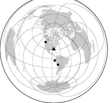
Nearby stations (2 deg radius)
| Station | Name | (Lat, Lon) | Start / End | Elevation |
| W19 | Johnson Farm, Montezuma, GA | (32.31, -83.91) | 2011-05-11 / 2014-05-13 | 119 m |
| Crust2 Type: | DG,thin Platform 1 km seds. |
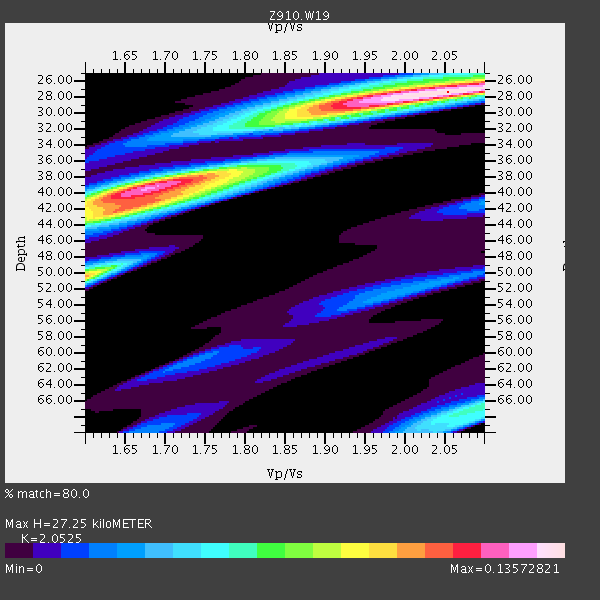
| Thickness Estimate: | 27 km |
| Thickness StdDev: | 5.9 km |
| Vp/Vs Estimate: | 2.05 |
| Vp/Vs StdDev: | 0.15 |
| Vs Estimate: | 3.198 km/s |
| Poisson's Ratio: | 0.34 |
| Peak Value: | 0.14 |
| Assumed Vp: | 6.565 km/s |
| Ps Weight: | 0.33333334 |
| PpPs Weight: | 0.33333334 |
| PsPs Weight: | 0.33333328 |
| Residual Complexity: | 0.755 |
| Nearby stations H: | +- |
| (2.0 deg) Vp/Vs: | +- |
0 with match > 90% ( 0.0 %) and 5 with match > 80% ( 16.666666 %) out of 30.
Download stack as xyz text file.
Azimuth Distribution of Events:
Prior Results for this Station
| Study | Thickness | Vp/Vs | Vp | Vs | Poissons Ratio | Extra |
| EARS | 27 km | 2.05 | 6.565 km/s | 3.198 km/s | 0.34 | |
| Crust2.0 | 31 km | 1.78 | 6.565 km/s | 3.684 km/s | 0.27 | DG,thin Platform 1 km seds. |
| Global Maxima | 27 km | 2.05 | 6.565 km/s | 3.198 km/s | 0.34 | amp=0.13572821 |
| Local Maxima 1 | 39 km | 1.68 | 6.565 km/s | 3.907 km/s | 0.23 | amp=0.120331734 |
| Local Maxima 2 | 50 km | 1.60 | 6.565 km/s | 4.103 km/s | 0.18 | amp=0.09358575 |
| Local Maxima 3 | 42 km | 1.65 | 6.565 km/s | 3.972 km/s | 0.21 | amp=0.078307405 |
| Local Maxima 4 | 66 km | 2.10 | 6.565 km/s | 3.13 km/s | 0.35 | amp=0.06029968 |
| Predicted Arrivals for vertical incidence (zero ray parameter) | |
| Ps | 4.37 SECOND |
| PpPs | 12.67 SECOND |
| PsPs/PpSs | 17.04 SECOND |
Events Processed for this Station
Download zip of receiver functions as SAC
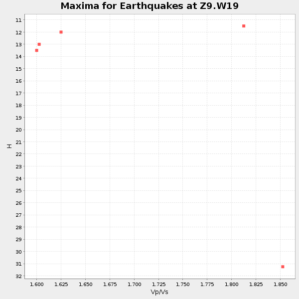
Plot maxima for each earthquake.
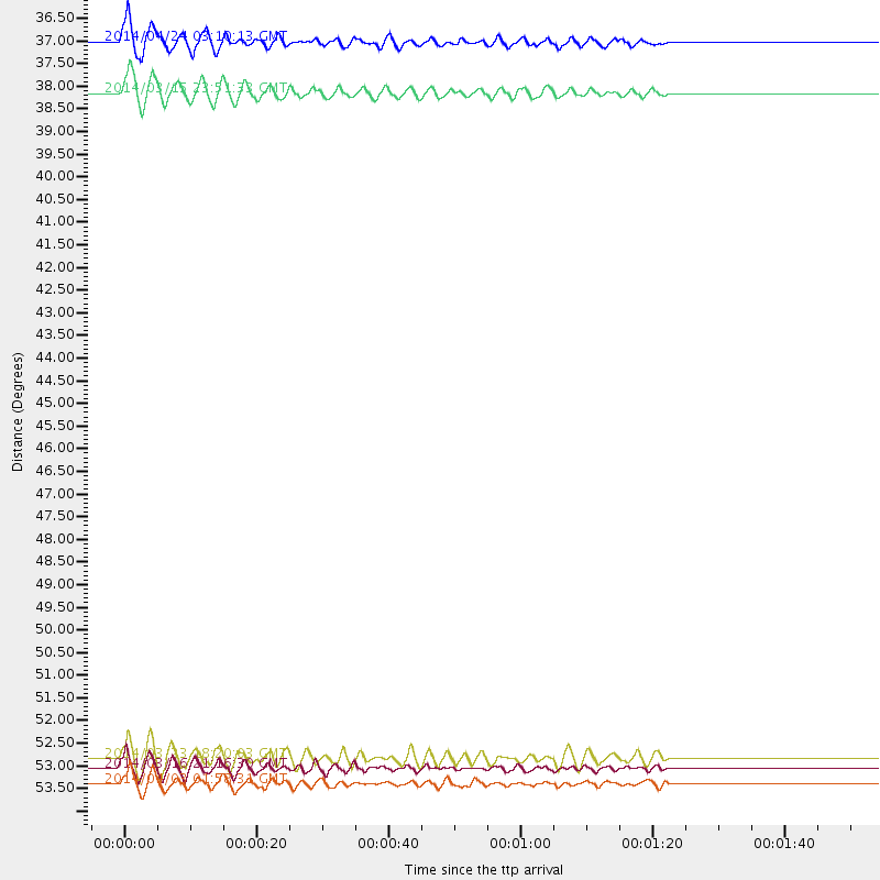
Events Used in the Stack
(5 events)| Radial Match | Distance | Baz | FERegion | Time | Lat/Lon | Depth | Magnitude |
| 89.95599 | 53.5 deg | 164.4 deg | Near Coast Of Northern Chile | 2014/03/16 21:16:30 GMT | (-19.9, -70.6) | 20 km | 6.7 MWW, 6.7 MWC, 7.0 MI |
| 89.41639 | 37.8 deg | 175.205 deg | Near Coast Of Northern Peru | 2014/03/15 23:51:33 GMT | (-5.6, -81.0) | 29 km | 6.3 MWW, 6.2 MWB, 6.3 MWC |
| 82.82987 | 53.3 deg | 164.554 deg | Near Coast Of Northern Chile | 2014/03/23 18:20:03 GMT | (-19.7, -70.8) | 35 km | 6.0 MB, 6.2 MWB, 6.2 MWW, 6.3 MWC |
| 81.786125 | 36.6 deg | 311.592 deg | Vancouver Island, Canada Region | 2014/04/24 03:10:13 GMT | (49.8, -127.4) | 11 km | 6.7 MWP, 6.7 MI |
| 80.81647 | 53.8 deg | 164.421 deg | Near Coast Of Northern Chile | 2014/04/03 01:58:31 GMT | (-20.3, -70.6) | 23 km | 6.5 MWW, 6.5 MWB, 6.6 MWC |
Losers
(25 events)| Radial Match | Distance | Baz | FERegion | Time | Lat/Lon | Depth | Magnitude | Reason |
| 96.70899 | 53.2 deg | 164.531 deg | Near Coast Of Northern Chile | 2014/04/01 23:46:46 GMT | (-19.6, -70.8) | 20 km | 8.2 MWW, 8.0 MI, 8.1 MWC | |
| 92.961105 | 54.1 deg | 164.43 deg | Near Coast Of Northern Chile | 2014/04/03 02:43:14 GMT | (-20.5, -70.5) | 31 km | 7.7 MWW, 7.4 MI, 7.7 MWC | |
| 87.864586 | 33.9 deg | 296.364 deg | Off Coast Of Northern California | 2014/03/10 05:18:13 GMT | (40.8, -125.1) | 17 km | 6.8 MW, 6.8 MWR, 6.9 MWW, 6.9 MWB, 7.0 MI, 7.0 MWC | |
| 86.6642 | 53.3 deg | 164.632 deg | Near Coast Of Northern Chile | 2014/03/22 12:59:59 GMT | (-19.8, -70.9) | 20 km | 6.2 MWW, 6.2 MWB, 6.3 MWC, 6.4 MWC | |
| 84.729996 | 53.2 deg | 163.742 deg | Near Coast Of Northern Chile | 2014/04/01 23:59:57 GMT | (-19.5, -70.2) | 22 km | 5.8 MB | |
| 81.991104 | 54.1 deg | 164.732 deg | Near Coast Of Northern Chile | 2014/04/04 01:37:51 GMT | (-20.6, -70.7) | 20 km | 6.1 MWP, 6.1 MWB, 6.1 MWW, 6.3 MWC | |
| 79.92716 | 46.9 deg | 168.936 deg | Near Coast Of Peru | 2014/02/18 23:35:58 GMT | (-14.2, -75.6) | 57 km | 6.0 MWB, 5.9 MWW, 5.9 MWC, 6.0 MWC | |
| 72.17874 | 68.6 deg | 50.194 deg | France | 2014/04/07 19:27:00 GMT | (44.5, 6.7) | 9.1 km | 5.0 MW | |
| 66.01009 | 56.2 deg | 162.95 deg | Northern Chile | 2014/02/10 11:00:09 GMT | (-22.3, -68.7) | 107 km | 5.2 MW | |
| 65.44876 | 51.9 deg | 323.606 deg | Southern Alaska | 2014/05/10 14:16:08 GMT | (60.0, -152.2) | 96 km | 5.8 ML, 5.5 MI, 5.7 MWP | |
| 61.2792 | 62.2 deg | 211.855 deg | Easter Island Region | 2014/02/14 07:44:15 GMT | (-23.0, -114.3) | 12 km | 5.6 MWW, 5.5 MWB, 5.6 MWC | |
| 61.104538 | 68.7 deg | 317.701 deg | Andreanof Islands, Aleutian Is. | 2014/01/16 07:33:09 GMT | (51.2, -179.2) | 27 km | 5.5 MWB, 5.2 ML, 5.5 ML, 5.6 MWC | |
| 60.993546 | 53.6 deg | 164.721 deg | Near Coast Of Northern Chile | 2014/04/02 04:46:18 GMT | (-20.2, -70.9) | 10 km | 5.8 MB | |
| 60.91738 | 46.7 deg | 169.85 deg | Near Coast Of Peru | 2014/03/15 08:59:21 GMT | (-14.1, -76.3) | 20 km | 6.1 MWW, 6.0 MWB, 6.2 MWC | |
| 60.026646 | 80.7 deg | 113.144 deg | Southern Mid-Atlantic Ridge | 2014/02/20 04:09:57 GMT | (-14.1, -14.6) | 14 km | 5.1 MW | |
| 58.169094 | 83.4 deg | 49.956 deg | Southern Greece | 2014/04/04 20:08:07 GMT | (37.2, 23.8) | 107 km | 5.5 MWB, 5.5 MWR, 5.6 MWC, 5.6 MWW | |
| 56.613457 | 82.9 deg | 324.896 deg | Kuril Islands | 2014/01/21 10:50:00 GMT | (49.1, 156.3) | 34 km | 5.5 MW | |
| 55.584583 | 54.7 deg | 156.703 deg | Southern Bolivia | 2014/01/27 16:42:37 GMT | (-19.3, -63.9) | 600 km | 5.6 MWB | |
| 54.02604 | 53.6 deg | 164.74 deg | Near Coast Of Northern Chile | 2014/04/07 13:43:20 GMT | (-20.2, -70.9) | 7.9 km | 5.8 MWB, 5.7 MWW, 5.7 MWC | |
| 52.97743 | 63.5 deg | 318.301 deg | Fox Islands, Aleutian Islands | 2014/02/26 21:13:40 GMT | (53.6, -171.8) | 265 km | 6.1 MWW, 5.9 MI, 5.9 ML, 6.1 MWC, 6.1 MWB, 6.2 MWC | |
| 51.595192 | 86.3 deg | 199.328 deg | Southern East Pacific Rise | 2014/05/12 18:38:37 GMT | (-50.0, -114.7) | 8.2 km | 5.8 MB | |
| 51.478443 | 94.5 deg | 202.998 deg | Southern East Pacific Rise | 2014/02/01 09:17:26 GMT | (-55.1, -126.6) | 10 km | 5.2 MW | |
| 43.470936 | 56.1 deg | 333.168 deg | Northern Alaska | 2014/05/03 08:57:12 GMT | (67.6, -162.2) | 0.9 km | 5.5 MB | |
| 40.494015 | 67.7 deg | 169.225 deg | Near Coast Of Central Chile | 2014/03/15 14:46:28 GMT | (-34.7, -71.8) | 45 km | 5.5 MB, 5.1 MWW | |
| 28.486 | 86.2 deg | 332.958 deg | Sakhalin, Russia | 2014/02/19 12:49:06 GMT | (52.2, 143.5) | 17 km | 4.9 MW |

