
Station Z9 W23N - Fort Valley State University, GA
Network: Z910 - Southeastern Suture of the Appalachian Margin Experiment
Nearby stations (2 deg radius)
| Station | Name | (Lat, Lon) | Start / End | Elevation |
| W23N | Fort Valley State University, GA | (32.52, -83.89) | 2013-10-19 / 2014-05-14 | 159 m |
| Crust2 Type: | DG,thin Platform 1 km seds. |
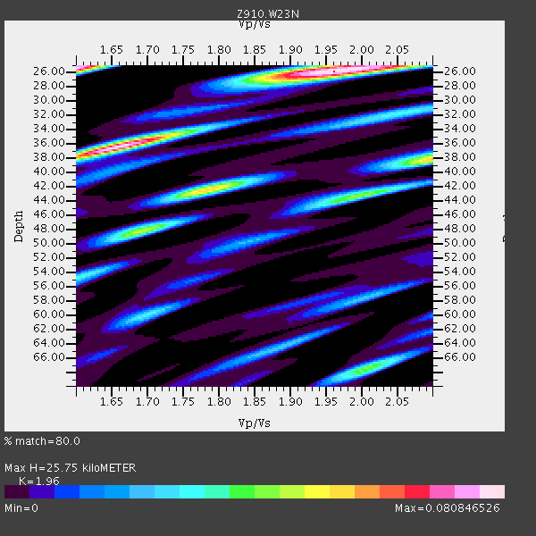
| Thickness Estimate: | 26 km |
| Thickness StdDev: | 6.4 km |
| Vp/Vs Estimate: | 1.96 |
| Vp/Vs StdDev: | 0.18 |
| Vs Estimate: | 3.349 km/s |
| Poisson's Ratio: | 0.32 |
| Peak Value: | 0.08 |
| Assumed Vp: | 6.565 km/s |
| Ps Weight: | 0.33333334 |
| PpPs Weight: | 0.33333334 |
| PsPs Weight: | 0.33333328 |
| Residual Complexity: | 0.763 |
| Nearby stations H: | +- |
| (2.0 deg) Vp/Vs: | +- |
2 with match > 90% ( 8.695652 %) and 8 with match > 80% ( 34.782608 %) out of 23.
Download stack as xyz text file.
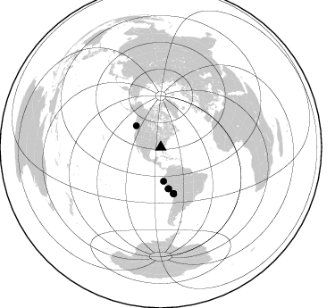
Azimuth Distribution of Events:
Prior Results for this Station
| Study | Thickness | Vp/Vs | Vp | Vs | Poissons Ratio | Extra |
| EARS | 26 km | 1.96 | 6.565 km/s | 3.349 km/s | 0.32 | |
| Crust2.0 | 31 km | 1.78 | 6.565 km/s | 3.684 km/s | 0.27 | DG,thin Platform 1 km seds. |
| Global Maxima | 26 km | 1.96 | 6.565 km/s | 3.349 km/s | 0.32 | amp=0.080846526 |
| Local Maxima 1 | 25 km | 1.60 | 6.565 km/s | 4.103 km/s | 0.18 | amp=0.07943165 |
| Local Maxima 2 | 36 km | 1.65 | 6.565 km/s | 3.978 km/s | 0.21 | amp=0.0766393 |
| Local Maxima 3 | 38 km | 2.10 | 6.565 km/s | 3.13 km/s | 0.35 | amp=0.05788566 |
| Local Maxima 4 | 48 km | 1.70 | 6.565 km/s | 3.873 km/s | 0.23 | amp=0.04554843 |
| Predicted Arrivals for vertical incidence (zero ray parameter) | |
| Ps | 3.77 SECOND |
| PpPs | 11.61 SECOND |
| PsPs/PpSs | 15.38 SECOND |
Events Processed for this Station
Download zip of receiver functions as SAC
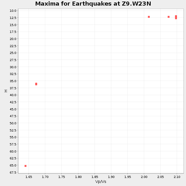
Plot maxima for each earthquake.
Events Used in the Stack
(8 events)| Radial Match | Distance | Baz | FERegion | Time | Lat/Lon | Depth | Magnitude |
| 92.36916 | 53.7 deg | 164.465 deg | Near Coast Of Northern Chile | 2014/03/16 21:16:30 GMT | (-19.9, -70.6) | 20 km | 6.7 MWW, 6.7 MWC, 7.0 MI |
| 90.35128 | 53.5 deg | 164.696 deg | Near Coast Of Northern Chile | 2014/03/22 12:59:59 GMT | (-19.8, -70.9) | 20 km | 6.2 MWW, 6.2 MWB, 6.3 MWC, 6.4 MWC |
| 89.33574 | 36.5 deg | 311.376 deg | Vancouver Island, Canada Region | 2014/04/24 03:10:13 GMT | (49.8, -127.4) | 11 km | 6.7 MWP, 6.7 MI |
| 87.72548 | 38.0 deg | 175.26 deg | Near Coast Of Northern Peru | 2014/03/15 23:51:33 GMT | (-5.6, -81.0) | 29 km | 6.3 MWW, 6.2 MWB, 6.3 MWC |
| 87.07737 | 54.0 deg | 164.485 deg | Near Coast Of Northern Chile | 2014/04/03 01:58:31 GMT | (-20.3, -70.6) | 23 km | 6.5 MWW, 6.5 MWB, 6.6 MWC |
| 85.3586 | 53.5 deg | 164.619 deg | Near Coast Of Northern Chile | 2014/03/23 18:20:03 GMT | (-19.7, -70.8) | 35 km | 6.0 MB, 6.2 MWB, 6.2 MWW, 6.3 MWC |
| 84.447815 | 47.1 deg | 169.0 deg | Near Coast Of Peru | 2014/02/18 23:35:58 GMT | (-14.2, -75.6) | 57 km | 6.0 MWB, 5.9 MWW, 5.9 MWC, 6.0 MWC |
| 82.53213 | 46.9 deg | 169.911 deg | Near Coast Of Peru | 2014/03/15 08:59:21 GMT | (-14.1, -76.3) | 20 km | 6.1 MWW, 6.0 MWB, 6.2 MWC |
Losers
(15 events)| Radial Match | Distance | Baz | FERegion | Time | Lat/Lon | Depth | Magnitude | Reason |
| 99.040825 | 63.4 deg | 318.235 deg | Fox Islands, Aleutian Islands | 2014/02/26 21:13:40 GMT | (53.6, -171.8) | 265 km | 6.1 MWW, 5.9 MI, 5.9 ML, 6.1 MWC, 6.1 MWB, 6.2 MWC | |
| 94.61383 | 54.3 deg | 164.494 deg | Near Coast Of Northern Chile | 2014/04/03 02:43:14 GMT | (-20.5, -70.5) | 31 km | 7.7 MWW, 7.4 MI, 7.7 MWC | |
| 94.42878 | 53.4 deg | 164.596 deg | Near Coast Of Northern Chile | 2014/04/01 23:46:46 GMT | (-19.6, -70.8) | 20 km | 8.2 MWW, 8.0 MI, 8.1 MWC | |
| 85.888695 | 53.4 deg | 163.809 deg | Near Coast Of Northern Chile | 2014/04/01 23:59:57 GMT | (-19.5, -70.2) | 22 km | 5.8 MB | |
| 85.28734 | 33.9 deg | 296.083 deg | Off Coast Of Northern California | 2014/03/10 05:18:13 GMT | (40.8, -125.1) | 17 km | 6.8 MW, 6.8 MWR, 6.9 MWW, 6.9 MWB, 7.0 MI, 7.0 MWC | |
| 78.600945 | 51.7 deg | 323.508 deg | Southern Alaska | 2014/05/10 14:16:08 GMT | (60.0, -152.2) | 96 km | 5.8 ML, 5.5 MI, 5.7 MWP | |
| 71.08817 | 53.5 deg | 164.721 deg | Near Coast Of Northern Chile | 2014/04/02 00:03:12 GMT | (-19.8, -70.9) | 10 km | 5.8 MB | |
| 66.00974 | 54.4 deg | 164.876 deg | Near Coast Of Northern Chile | 2014/01/04 00:11:48 GMT | (-20.7, -70.8) | 26 km | 5.7 MWW, 5.8 MWB, 5.8 MWC | |
| 55.999233 | 57.9 deg | 164.127 deg | Northern Chile | 2014/03/20 18:41:32 GMT | (-24.0, -69.2) | 96 km | 5.1 MW | |
| 53.12566 | 56.0 deg | 333.104 deg | Northern Alaska | 2014/05/03 08:57:12 GMT | (67.6, -162.2) | 0.9 km | 5.5 MB | |
| 52.605877 | 78.2 deg | 174.826 deg | Off Coast Of Southern Chile | 2014/03/02 11:14:42 GMT | (-45.8, -76.6) | 23 km | 5.2 MW | |
| 52.068535 | 68.5 deg | 317.652 deg | Andreanof Islands, Aleutian Is. | 2014/01/16 07:33:09 GMT | (51.2, -179.2) | 27 km | 5.5 MWB, 5.2 ML, 5.5 ML, 5.6 MWC | |
| 48.772385 | 73.0 deg | 322.347 deg | Near Islands, Aleutian Islands | 2014/04/07 07:48:29 GMT | (53.0, 171.0) | 26 km | 5.2 MW | |
| 43.450825 | 96.4 deg | 151.646 deg | South Georgia Island Region | 2014/03/17 13:24:48 GMT | (-53.2, -32.3) | 5.4 km | 5.6 MB, 5.8 MWB, 5.9 MWC | |
| 29.800413 | 42.5 deg | 213.9 deg | Central East Pacific Rise | 2014/01/07 23:02:53 GMT | (-4.5, -106.1) | 10 km | 5.7 MWB, 5.8 MWC |

