
Station Z9 W28 - Peters Farm, Forsyth, GA
Network: Z910 - Southeastern Suture of the Appalachian Margin Experiment
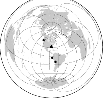
Nearby stations (2 deg radius)
| Station | Name | (Lat, Lon) | Start / End | Elevation |
| W28 | Peters Farm, Forsyth, GA | (33.19, -83.90) | 2011-05-10 / 2014-05-13 | 183 m |
| Crust2 Type: | DG,thin Platform 1 km seds. |
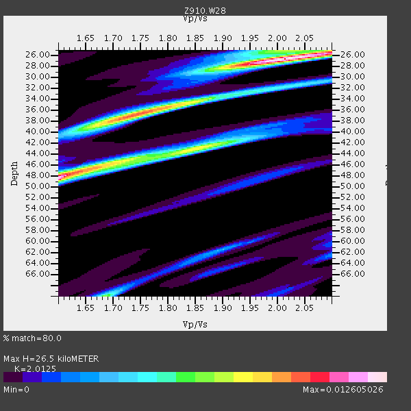
| Thickness Estimate: | 26 km |
| Thickness StdDev: | 14 km |
| Vp/Vs Estimate: | 2.01 |
| Vp/Vs StdDev: | 0.19 |
| Vs Estimate: | 3.262 km/s |
| Poisson's Ratio: | 0.34 |
| Peak Value: | 0.01 |
| Assumed Vp: | 6.565 km/s |
| Ps Weight: | 0.33333334 |
| PpPs Weight: | 0.33333334 |
| PsPs Weight: | 0.33333328 |
| Residual Complexity: | 0.776 |
| Nearby stations H: | +- |
| (2.0 deg) Vp/Vs: | +- |
4 with match > 90% ( 13.333333 %) and 5 with match > 80% ( 16.666666 %) out of 30.
Download stack as xyz text file.
Azimuth Distribution of Events:
Prior Results for this Station
| Study | Thickness | Vp/Vs | Vp | Vs | Poissons Ratio | Extra |
| EARS | 26 km | 2.01 | 6.565 km/s | 3.262 km/s | 0.34 | |
| Crust2.0 | 31 km | 1.78 | 6.565 km/s | 3.684 km/s | 0.27 | DG,thin Platform 1 km seds. |
| Global Maxima | 26 km | 2.01 | 6.565 km/s | 3.262 km/s | 0.34 | amp=0.012605026 |
| Local Maxima 1 | 48 km | 1.60 | 6.565 km/s | 4.103 km/s | 0.18 | amp=0.011865658 |
| Local Maxima 2 | 36 km | 1.75 | 6.565 km/s | 3.757 km/s | 0.26 | amp=0.0091813775 |
| Local Maxima 3 | 43 km | 1.85 | 6.565 km/s | 3.544 km/s | 0.29 | amp=0.007772292 |
| Local Maxima 4 | 70 km | 1.69 | 6.565 km/s | 3.896 km/s | 0.23 | amp=0.006578676 |
| Predicted Arrivals for vertical incidence (zero ray parameter) | |
| Ps | 4.09 SECOND |
| PpPs | 12.16 SECOND |
| PsPs/PpSs | 16.25 SECOND |
Events Processed for this Station
Download zip of receiver functions as SAC
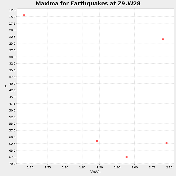
Plot maxima for each earthquake.
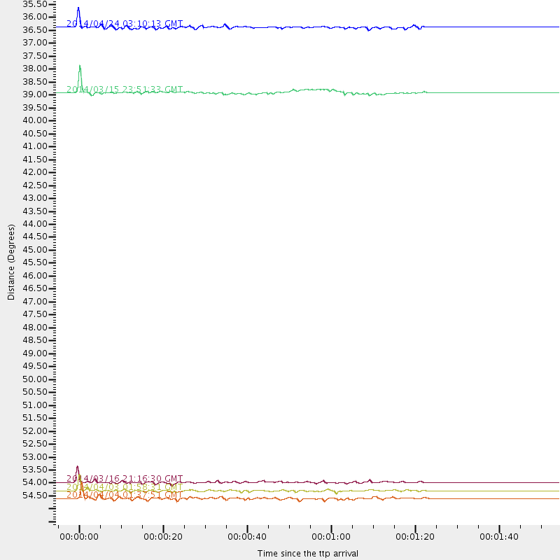
Events Used in the Stack
(5 events)| Radial Match | Distance | Baz | FERegion | Time | Lat/Lon | Depth | Magnitude |
| 95.30895 | 54.3 deg | 164.577 deg | Near Coast Of Northern Chile | 2014/03/16 21:16:30 GMT | (-19.9, -70.6) | 20 km | 6.7 MWW, 6.7 MWC, 7.0 MI |
| 93.25333 | 54.7 deg | 164.596 deg | Near Coast Of Northern Chile | 2014/04/03 01:58:31 GMT | (-20.3, -70.6) | 23 km | 6.5 MWW, 6.5 MWB, 6.6 MWC |
| 91.2148 | 36.0 deg | 310.699 deg | Vancouver Island, Canada Region | 2014/04/24 03:10:13 GMT | (49.8, -127.4) | 11 km | 6.7 MWP, 6.7 MI |
| 90.804344 | 55.0 deg | 164.902 deg | Near Coast Of Northern Chile | 2014/04/04 01:37:51 GMT | (-20.6, -70.7) | 20 km | 6.1 MWP, 6.1 MWB, 6.1 MWW, 6.3 MWC |
| 86.85327 | 38.7 deg | 175.306 deg | Near Coast Of Northern Peru | 2014/03/15 23:51:33 GMT | (-5.6, -81.0) | 29 km | 6.3 MWW, 6.2 MWB, 6.3 MWC |
Losers
(25 events)| Radial Match | Distance | Baz | FERegion | Time | Lat/Lon | Depth | Magnitude | Reason |
| 98.42311 | 54.0 deg | 164.709 deg | Near Coast Of Northern Chile | 2014/04/01 23:46:46 GMT | (-19.6, -70.8) | 20 km | 8.2 MWW, 8.0 MI, 8.1 MWC | |
| 97.399124 | 54.9 deg | 164.603 deg | Near Coast Of Northern Chile | 2014/04/03 02:43:14 GMT | (-20.5, -70.5) | 31 km | 7.7 MWW, 7.4 MI, 7.7 MWC | |
| 94.69247 | 33.6 deg | 295.191 deg | Off Coast Of Northern California | 2014/03/10 05:18:13 GMT | (40.8, -125.1) | 17 km | 6.8 MW, 6.8 MWR, 6.9 MWW, 6.9 MWB, 7.0 MI, 7.0 MWC | |
| 74.953705 | 55.4 deg | 332.899 deg | Northern Alaska | 2014/05/03 08:57:12 GMT | (67.6, -162.2) | 0.9 km | 5.5 MB | |
| 74.73156 | 47.7 deg | 169.097 deg | Near Coast Of Peru | 2014/02/18 23:35:58 GMT | (-14.2, -75.6) | 57 km | 6.0 MWB, 5.9 MWW, 5.9 MWC, 6.0 MWC | |
| 73.04412 | 47.6 deg | 170.0 deg | Near Coast Of Peru | 2014/03/15 08:59:21 GMT | (-14.1, -76.3) | 20 km | 6.1 MWW, 6.0 MWB, 6.2 MWC | |
| 72.003975 | 54.0 deg | 163.928 deg | Near Coast Of Northern Chile | 2014/04/01 23:59:57 GMT | (-19.5, -70.2) | 22 km | 5.8 MB | |
| 69.261734 | 51.2 deg | 323.194 deg | Southern Alaska | 2014/05/10 14:16:08 GMT | (60.0, -152.2) | 96 km | 5.8 ML, 5.5 MI, 5.7 MWP | |
| 68.3912 | 68.0 deg | 317.47 deg | Andreanof Islands, Aleutian Is. | 2014/01/16 07:33:09 GMT | (51.2, -179.2) | 27 km | 5.5 MWB, 5.2 ML, 5.5 ML, 5.6 MWC | |
| 67.705925 | 85.4 deg | 324.435 deg | Kuril Islands | 2014/01/08 16:50:28 GMT | (46.5, 153.2) | 40 km | 5.0 mb | |
| 65.653465 | 87.1 deg | 199.846 deg | Southern East Pacific Rise | 2014/05/12 20:07:51 GMT | (-49.7, -115.3) | 10 km | 5.4 MW | |
| 64.662636 | 82.8 deg | 50.04 deg | Southern Greece | 2014/04/04 20:08:07 GMT | (37.2, 23.8) | 107 km | 5.5 MWB, 5.5 MWR, 5.6 MWC, 5.6 MWW | |
| 63.17974 | 54.3 deg | 164.947 deg | Near Coast Of Northern Chile | 2014/03/18 21:33:05 GMT | (-20.0, -70.9) | 6.3 km | 5.1 mb | |
| 62.667397 | 54.2 deg | 164.773 deg | Near Coast Of Northern Chile | 2014/03/24 11:40:44 GMT | (-19.8, -70.8) | 23 km | 5.5 MB, 5.5 MWR, 5.6 MWW, 5.7 MWC | |
| 61.97271 | 77.6 deg | 51.652 deg | Southern Italy | 2014/04/05 10:24:45 GMT | (38.9, 17.2) | 56 km | 4.8 MW | |
| 61.82383 | 54.5 deg | 164.525 deg | Near Coast Of Northern Chile | 2014/04/11 12:00:51 GMT | (-20.1, -70.5) | 22 km | 5.5 MB | |
| 56.81216 | 66.7 deg | 168.713 deg | Near Coast Of Central Chile | 2014/04/05 02:22:38 GMT | (-32.8, -71.6) | 40 km | 5.6 MWC, 5.6 MWC | |
| 55.130146 | 53.9 deg | 164.824 deg | Near Coast Of Northern Chile | 2014/04/02 01:20:59 GMT | (-19.6, -70.9) | 22 km | 5.2 mb | |
| 53.75748 | 96.6 deg | 325.318 deg | Near East Coast Of Honshu, Japan | 2014/02/05 17:32:13 GMT | (38.7, 142.4) | 46 km | 5.3 MW | |
| 52.394127 | 55.5 deg | 332.955 deg | Northern Alaska | 2014/04/18 18:44:17 GMT | (67.7, -162.5) | 1.0 km | 5.5 MB, 5.4 MI | |
| 44.066975 | 54.4 deg | 164.785 deg | Near Coast Of Northern Chile | 2014/03/17 05:24:07 GMT | (-20.1, -70.8) | 10 km | 4.6 mb | |
| 41.95103 | 96.2 deg | 204.413 deg | Pacific-Antarctic Ridge | 2014/04/17 13:10:06 GMT | (-55.1, -129.5) | 16 km | 5.5 MB, 5.7 MWC | |
| 34.497963 | 67.9 deg | 317.473 deg | Andreanof Islands, Aleutian Is. | 2014/03/13 13:20:59 GMT | (51.2, -179.1) | 26 km | 5.6 MWC, 5.1 ML, 5.4 MWW, 5.4 MWB, 5.5 ML, 5.6 MWC | |
| 27.314743 | 72.4 deg | 322.216 deg | Near Islands, Aleutian Islands | 2014/04/07 07:48:29 GMT | (53.0, 171.0) | 26 km | 5.2 MW | |
| 25.911697 | 35.8 deg | 300.185 deg | Off Coast Of Oregon | 2014/05/12 18:51:00 GMT | (43.7, -128.1) | 14 km | 5.5 MW |

