
Station Z9 W30 - Hood Farm, Loganville, GA
Network: Z910 - Southeastern Suture of the Appalachian Margin Experiment
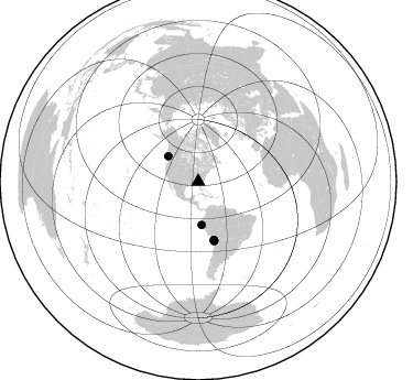
Nearby stations (2 deg radius)
| Station | Name | (Lat, Lon) | Start / End | Elevation |
| W30 | Hood Farm, Loganville, GA | (33.73, -83.91) | 2011-05-09 / 2014-05-20 | 246 m |
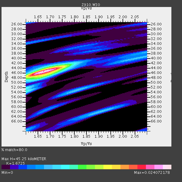
| Crust2 Type: | DG,thin Platform 1 km seds. |
| Thickness Estimate: | 45 km |
| Thickness StdDev: | 5.3 km |
| Vp/Vs Estimate: | 1.67 |
| Vp/Vs StdDev: | 0.10 |
| Vs Estimate: | 3.925 km/s |
| Poisson's Ratio: | 0.22 |
| Peak Value: | 0.02 |
| Assumed Vp: | 6.565 km/s |
| Ps Weight: | 0.33333334 |
| PpPs Weight: | 0.33333334 |
| PsPs Weight: | 0.33333328 |
| Residual Complexity: | 0.516 |
| Nearby stations H: | +- |
| (2.0 deg) Vp/Vs: | +- |
5 with match > 90% ( 19.23077 %) and 6 with match > 80% ( 23.076923 %) out of 26.
Download stack as xyz text file.
Azimuth Distribution of Events:
Prior Results for this Station
| Study | Thickness | Vp/Vs | Vp | Vs | Poissons Ratio | Extra |
| EARS | 45 km | 1.67 | 6.565 km/s | 3.925 km/s | 0.22 | |
| Crust2.0 | 31 km | 1.78 | 6.565 km/s | 3.684 km/s | 0.27 | DG,thin Platform 1 km seds. |
| Global Maxima | 45 km | 1.67 | 6.565 km/s | 3.925 km/s | 0.22 | amp=0.024072178 |
| Local Maxima 1 | 47 km | 1.68 | 6.565 km/s | 3.902 km/s | 0.23 | amp=0.009153184 |
| Local Maxima 2 | 62 km | 1.91 | 6.565 km/s | 3.441 km/s | 0.31 | amp=0.0072537875 |
| Local Maxima 3 | 53 km | 1.81 | 6.565 km/s | 3.632 km/s | 0.28 | amp=0.006887664 |
| Local Maxima 4 | 42 km | 1.75 | 6.565 km/s | 3.746 km/s | 0.26 | amp=0.0068588257 |
| Predicted Arrivals for vertical incidence (zero ray parameter) | |
| Ps | 4.64 SECOND |
| PpPs | 18.42 SECOND |
| PsPs/PpSs | 23.06 SECOND |
Events Processed for this Station
Download zip of receiver functions as SAC
Plot maxima for each earthquake.
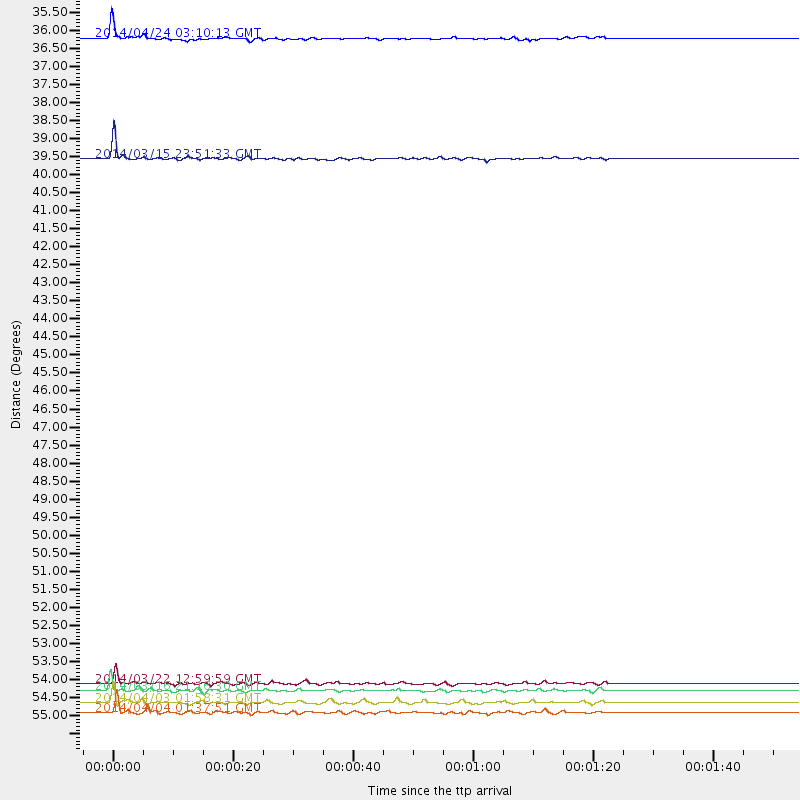
Events Used in the Stack
(6 events)| Radial Match | Distance | Baz | FERegion | Time | Lat/Lon | Depth | Magnitude |
| 95.2686 | 54.8 deg | 164.665 deg | Near Coast Of Northern Chile | 2014/03/16 21:16:30 GMT | (-19.9, -70.6) | 20 km | 6.7 MWW, 6.7 MWC, 7.0 MI |
| 95.12285 | 35.7 deg | 310.127 deg | Vancouver Island, Canada Region | 2014/04/24 03:10:13 GMT | (49.8, -127.4) | 11 km | 6.7 MWP, 6.7 MI |
| 92.75474 | 55.2 deg | 164.683 deg | Near Coast Of Northern Chile | 2014/04/03 01:58:31 GMT | (-20.3, -70.6) | 23 km | 6.5 MWW, 6.5 MWB, 6.6 MWC |
| 90.859695 | 54.6 deg | 164.895 deg | Near Coast Of Northern Chile | 2014/03/22 12:59:59 GMT | (-19.8, -70.9) | 20 km | 6.2 MWW, 6.2 MWB, 6.3 MWC, 6.4 MWC |
| 90.258575 | 55.5 deg | 164.986 deg | Near Coast Of Northern Chile | 2014/04/04 01:37:51 GMT | (-20.6, -70.7) | 20 km | 6.1 MWP, 6.1 MWB, 6.1 MWW, 6.3 MWC |
| 89.91891 | 39.2 deg | 175.341 deg | Near Coast Of Northern Peru | 2014/03/15 23:51:33 GMT | (-5.6, -81.0) | 29 km | 6.3 MWW, 6.2 MWB, 6.3 MWC |
Losers
(20 events)| Radial Match | Distance | Baz | FERegion | Time | Lat/Lon | Depth | Magnitude | Reason |
| 99.084564 | 54.5 deg | 164.797 deg | Near Coast Of Northern Chile | 2014/04/01 23:46:46 GMT | (-19.6, -70.8) | 20 km | 8.2 MWW, 8.0 MI, 8.1 MWC | |
| 96.34841 | 55.7 deg | 164.655 deg | Near Coast Of Northern Chile | 2014/04/03 05:51:44 GMT | (-20.8, -70.4) | 27 km | 5.5 MB, 5.3 MWR | |
| 95.8855 | 55.4 deg | 164.689 deg | Near Coast Of Northern Chile | 2014/04/03 02:43:14 GMT | (-20.5, -70.5) | 31 km | 7.7 MWW, 7.4 MI, 7.7 MWC | |
| 94.49749 | 33.3 deg | 294.442 deg | Off Coast Of Northern California | 2014/03/10 05:18:13 GMT | (40.8, -125.1) | 17 km | 6.8 MW, 6.8 MWR, 6.9 MWW, 6.9 MWB, 7.0 MI, 7.0 MWC | |
| 91.47237 | 55.7 deg | 164.864 deg | Near Coast Of Northern Chile | 2014/04/03 05:28:50 GMT | (-20.8, -70.6) | 11 km | 5.6 mb | |
| 90.56155 | 50.7 deg | 322.928 deg | Southern Alaska | 2014/05/10 14:16:08 GMT | (60.0, -152.2) | 96 km | 5.8 ML, 5.5 MI, 5.7 MWP | |
| 88.50132 | 55.1 deg | 164.824 deg | Near Coast Of Northern Chile | 2014/04/02 00:33:45 GMT | (-20.2, -70.7) | 13 km | 5.5 MB | |
| 78.47094 | 54.5 deg | 164.022 deg | Near Coast Of Northern Chile | 2014/04/01 23:59:57 GMT | (-19.5, -70.2) | 22 km | 5.8 MB | |
| 69.562225 | 48.1 deg | 170.068 deg | Near Coast Of Peru | 2014/03/15 08:59:21 GMT | (-14.1, -76.3) | 20 km | 6.1 MWW, 6.0 MWB, 6.2 MWC | |
| 66.386444 | 54.6 deg | 165.009 deg | Near Coast Of Northern Chile | 2014/03/22 13:29:57 GMT | (-19.8, -71.0) | 10 km | 5.5 MB, 5.4 MWR, 5.6 MWW, 5.6 MWC | |
| 64.173164 | 54.9 deg | 332.725 deg | Northern Alaska | 2014/05/03 08:57:12 GMT | (67.6, -162.2) | 0.9 km | 5.5 MB | |
| 62.594162 | 55.0 deg | 332.782 deg | Northern Alaska | 2014/04/18 18:44:17 GMT | (67.7, -162.5) | 1.0 km | 5.5 MB, 5.4 MI | |
| 54.759453 | 55.0 deg | 164.871 deg | Near Coast Of Northern Chile | 2014/03/17 05:24:07 GMT | (-20.1, -70.8) | 10 km | 4.6 mb | |
| 54.21705 | 54.6 deg | 164.819 deg | Near Coast Of Northern Chile | 2014/03/23 18:20:03 GMT | (-19.7, -70.8) | 35 km | 6.0 MB, 6.2 MWB, 6.2 MWW, 6.3 MWC | |
| 53.74754 | 97.5 deg | 151.564 deg | South Georgia Island Region | 2014/03/17 13:24:48 GMT | (-53.2, -32.3) | 5.4 km | 5.6 MB, 5.8 MWB, 5.9 MWC | |
| 52.7374 | 54.8 deg | 164.919 deg | Near Coast Of Northern Chile | 2014/03/17 11:12:17 GMT | (-19.9, -70.9) | 26 km | 5.0 MW | |
| 44.38264 | 55.0 deg | 332.827 deg | Northern Alaska | 2014/04/18 18:56:47 GMT | (67.7, -162.5) | 17 km | 5.7 MW | |
| 40.366673 | 87.7 deg | 199.299 deg | Southern East Pacific Rise | 2014/05/12 18:38:37 GMT | (-50.0, -114.7) | 8.2 km | 5.8 MB | |
| 39.31829 | 96.0 deg | 326.013 deg | Eastern Honshu, Japan | 2014/04/02 23:22:47 GMT | (39.2, 141.8) | 56 km | 5.6 MB, 5.5 MWC | |
| 34.514275 | 54.8 deg | 164.887 deg | Near Coast Of Northern Chile | 2014/05/05 22:52:23 GMT | (-19.9, -70.8) | 12 km | 4.9 Mww |

