
Station ZB B02 - Station B02, Mexico RAMP Oaxaca Experiment
Network: ZB17 - Rapid Aftershock Deployment for the September 2017 M=8.1 and M.7.1 Earthquakes i
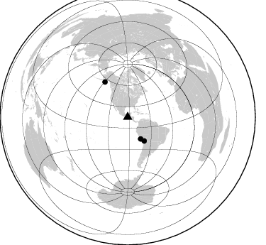
Nearby stations (2 deg radius)
| Station | Name | (Lat, Lon) | Start / End | Elevation |
| B02 | Station B02, Mexico RAMP Oaxaca Experiment | (15.28, -92.69) | 2017-10-04 / 2018-03-25 | 34 m |
| Crust2 Type: | S2,continental slope, margin, transition 2 km seds. |
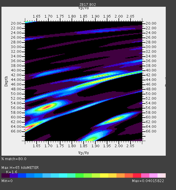
| Thickness Estimate: | 65 km |
| Thickness StdDev: | 8.4 km |
| Vp/Vs Estimate: | 1.60 |
| Vp/Vs StdDev: | 0.15 |
| Vs Estimate: | 3.78 km/s |
| Poisson's Ratio: | 0.18 |
| Peak Value: | 0.04 |
| Assumed Vp: | 6.048 km/s |
| Ps Weight: | 0.33333334 |
| PpPs Weight: | 0.33333334 |
| PsPs Weight: | 0.33333328 |
| Residual Complexity: | 0.844 |
| Nearby stations H: | +- |
| (2.0 deg) Vp/Vs: | +- |
2 with match > 90% ( 12.5 %) and 3 with match > 80% ( 18.75 %) out of 16.
Download stack as xyz text file.
Azimuth Distribution of Events:
Prior Results for this Station
| Study | Thickness | Vp/Vs | Vp | Vs | Poissons Ratio | Extra |
| EARS | 65 km | 1.60 | 6.048 km/s | 3.78 km/s | 0.18 | |
| Crust2.0 | 24 km | 1.81 | 6.048 km/s | 3.34 km/s | 0.28 | S2,continental slope, margin, transition 2 km seds. |
| Global Maxima | 65 km | 1.60 | 6.048 km/s | 3.78 km/s | 0.18 | amp=0.04015822 |
| Local Maxima 1 | 61 km | 1.98 | 6.048 km/s | 3.062 km/s | 0.33 | amp=0.028083611 |
| Local Maxima 2 | 44 km | 1.93 | 6.048 km/s | 3.126 km/s | 0.32 | amp=0.027230257 |
| Local Maxima 3 | 56 km | 1.69 | 6.048 km/s | 3.579 km/s | 0.23 | amp=0.025138244 |
| Local Maxima 4 | 42 km | 1.91 | 6.048 km/s | 3.162 km/s | 0.31 | amp=0.022450816 |
| Predicted Arrivals for vertical incidence (zero ray parameter) | |
| Ps | 6.45 SECOND |
| PpPs | 27.94 SECOND |
| PsPs/PpSs | 34.39 SECOND |
Events Processed for this Station
Download zip of receiver functions as SAC
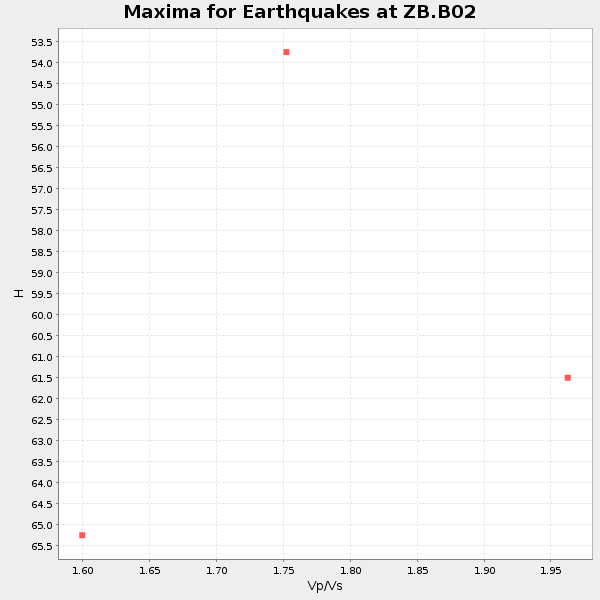
Plot maxima for each earthquake.
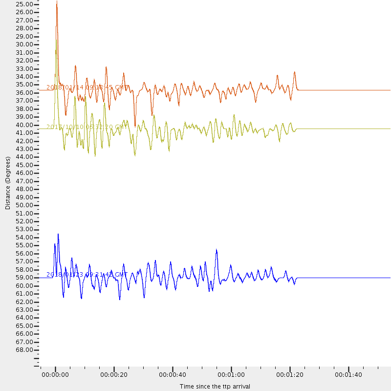
Events Used in the Stack
(3 events)| Radial Match | Distance | Baz | FERegion | Time | Lat/Lon | Depth | Magnitude |
| 92.43141 | 40.5 deg | 145.141 deg | Northern Chile | 2017/10/10 06:32:20 GMT | (-18.5, -69.6) | 82 km | 6.3 Mww |
| 91.2974 | 35.6 deg | 149.347 deg | Near Coast Of Peru | 2018/01/14 09:18:45 GMT | (-15.8, -74.7) | 36 km | 7.1 mww |
| 81.05343 | 58.9 deg | 326.926 deg | Gulf Of Alaska | 2018/01/23 09:31:42 GMT | (56.0, -149.1) | 25 km | 7.9 Mww |
Losers
(13 events)| Radial Match | Distance | Baz | FERegion | Time | Lat/Lon | Depth | Magnitude | Reason |
| 90.00665 | 77.5 deg | 1.737 deg | North Of Franz Josef Land | 2017/10/28 16:13:54 GMT | (86.9, 54.5) | 10 km | 5.8 Mww | |
| 79.866165 | 40.9 deg | 145.436 deg | Northern Chile | 2018/01/21 01:06:42 GMT | (-18.9, -69.6) | 111 km | 6.3 Mww | |
| 71.92455 | 95.6 deg | 320.452 deg | East Of Kuril Islands | 2018/03/07 04:40:12 GMT | (45.8, 152.3) | 29 km | 5.8 Mww | |
| 70.41535 | 42.6 deg | 210.273 deg | Southern East Pacific Rise | 2017/12/19 05:35:29 GMT | (-21.9, -114.2) | 10 km | 5.6 mb | |
| 66.88848 | 71.3 deg | 195.436 deg | Southern East Pacific Rise | 2017/12/29 21:20:53 GMT | (-53.1, -117.4) | 10 km | 5.7 Mww | |
| 64.99393 | 78.3 deg | 321.326 deg | Rat Islands, Aleutian Islands | 2017/10/08 22:34:33 GMT | (52.4, 176.8) | 112 km | 6.6 mww | |
| 61.302155 | 88.4 deg | 249.912 deg | Tonga Islands | 2017/10/08 14:04:38 GMT | (-19.0, -175.6) | 10 km | 6.1 Mww | |
| 58.13507 | 70.3 deg | 96.799 deg | Central Mid-Atlantic Ridge | 2017/11/30 06:32:52 GMT | (-1.1, -23.5) | 10 km | 6.5 Mi | |
| 57.965153 | 84.1 deg | 325.5 deg | Komandorskiye Ostrova Region | 2018/01/07 02:24:06 GMT | (55.1, 165.7) | 35 km | 5.7 mb | |
| 48.35562 | 84.9 deg | 252.671 deg | Samoa Islands Region | 2017/12/24 17:33:36 GMT | (-15.3, -172.9) | 10 km | 5.5 Mwb | |
| 42.544 | 59.8 deg | 170.928 deg | West Chile Rise | 2018/03/08 14:15:18 GMT | (-44.0, -81.8) | 10 km | 5.5 Mww | |
| 24.780226 | 86.6 deg | 254.234 deg | Samoa Islands Region | 2017/11/20 18:51:04 GMT | (-14.4, -175.1) | 10 km | 6.2 Mi | |
| 20.293604 | 78.3 deg | 94.715 deg | North Of Ascension Island | 2018/03/10 21:45:36 GMT | (-1.4, -15.2) | 10 km | 5.9 Mww |

