
Station ZB B06 - Station B06, Mexico RAMP Oaxaca Experiment
Network: ZB17 - Rapid Aftershock Deployment for the September 2017 M=8.1 and M.7.1 Earthquakes i
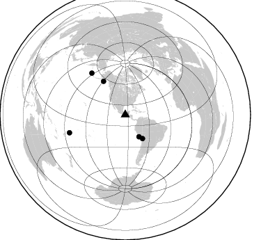
Nearby stations (2 deg radius)
| Station | Name | (Lat, Lon) | Start / End | Elevation |
| B06 | Station B06, Mexico RAMP Oaxaca Experiment | (16.29, -94.19) | 2017-10-04 / 2018-03-25 | 20 m |
| Crust2 Type: | L2,thin continental arc, Mexico, 2 km seds. |
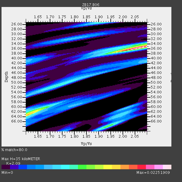
| Thickness Estimate: | 35 km |
| Thickness StdDev: | 13 km |
| Vp/Vs Estimate: | 2.09 |
| Vp/Vs StdDev: | 0.16 |
| Vs Estimate: | 3.08 km/s |
| Poisson's Ratio: | 0.35 |
| Peak Value: | 0.02 |
| Assumed Vp: | 6.438 km/s |
| Ps Weight: | 0.33333334 |
| PpPs Weight: | 0.33333334 |
| PsPs Weight: | 0.33333328 |
| Residual Complexity: | 0.753 |
| Nearby stations H: | +- |
| (2.0 deg) Vp/Vs: | +- |
3 with match > 90% ( 33.333332 %) and 5 with match > 80% ( 55.555557 %) out of 9.
Download stack as xyz text file.
Azimuth Distribution of Events:
Prior Results for this Station
| Study | Thickness | Vp/Vs | Vp | Vs | Poissons Ratio | Extra |
| EARS | 35 km | 2.09 | 6.438 km/s | 3.08 km/s | 0.35 | |
| Crust2.0 | 34 km | 1.78 | 6.438 km/s | 3.624 km/s | 0.27 | L2,thin continental arc, Mexico, 2 km seds. |
| Global Maxima | 35 km | 2.09 | 6.438 km/s | 3.08 km/s | 0.35 | amp=0.02251909 |
| Local Maxima 1 | 62 km | 1.63 | 6.438 km/s | 3.956 km/s | 0.20 | amp=0.013523415 |
| Local Maxima 2 | 68 km | 1.94 | 6.438 km/s | 3.323 km/s | 0.32 | amp=0.011792868 |
| Local Maxima 3 | 25 km | 1.91 | 6.438 km/s | 3.375 km/s | 0.31 | amp=0.0091882115 |
| Local Maxima 4 | 52 km | 1.71 | 6.438 km/s | 3.76 km/s | 0.24 | amp=0.008730508 |
| Predicted Arrivals for vertical incidence (zero ray parameter) | |
| Ps | 5.93 SECOND |
| PpPs | 16.80 SECOND |
| PsPs/PpSs | 22.72 SECOND |
Events Processed for this Station
Download zip of receiver functions as SAC
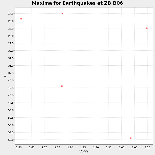
Plot maxima for each earthquake.
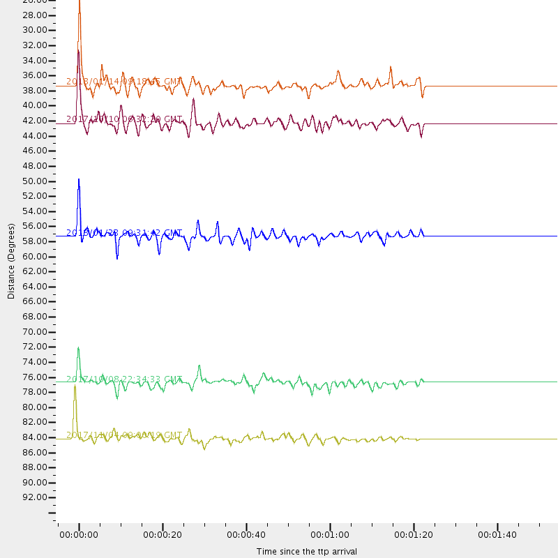
Events Used in the Stack
(5 events)| Radial Match | Distance | Baz | FERegion | Time | Lat/Lon | Depth | Magnitude |
| 95.09381 | 57.3 deg | 326.934 deg | Gulf Of Alaska | 2018/01/23 09:31:42 GMT | (56.0, -149.1) | 25 km | 7.9 Mww |
| 94.047356 | 84.1 deg | 252.207 deg | Tonga Islands | 2017/11/04 09:00:19 GMT | (-15.4, -173.2) | 10 km | 6.8 Mww |
| 93.49777 | 42.2 deg | 144.058 deg | Northern Chile | 2017/10/10 06:32:20 GMT | (-18.5, -69.6) | 82 km | 6.3 Mww |
| 89.67043 | 37.2 deg | 147.975 deg | Near Coast Of Peru | 2018/01/14 09:18:45 GMT | (-15.8, -74.7) | 36 km | 7.1 mww |
| 83.233025 | 76.7 deg | 321.03 deg | Rat Islands, Aleutian Islands | 2017/10/08 22:34:33 GMT | (52.4, 176.8) | 112 km | 6.6 mww |
Losers
(4 events)| Radial Match | Distance | Baz | FERegion | Time | Lat/Lon | Depth | Magnitude | Reason |
| 58.79048 | 69.3 deg | 95.239 deg | Central Mid-Atlantic Ridge | 2017/10/06 02:03:48 GMT | (1.0, -25.5) | 10 km | 5.5 Mww | |
| 41.868088 | 85.5 deg | 253.735 deg | Samoa Islands Region | 2017/11/20 18:51:04 GMT | (-14.4, -175.1) | 10 km | 6.2 Mi | |
| 33.362164 | 31.0 deg | 80.22 deg | Leeward Islands | 2018/02/09 17:43:34 GMT | (19.0, -61.7) | 9.9 km | 5.5 Mi | |
| 19.879116 | 89.2 deg | 250.429 deg | Fiji Islands Region | 2017/11/05 01:35:28 GMT | (-18.6, -177.7) | 483 km | 5.5 Mww |

