
Station ZB B09 - Station B09, Mexico RAMP Oaxaca Experiment
Network: ZB17 - Rapid Aftershock Deployment for the September 2017 M=8.1 and M.7.1 Earthquakes i
Nearby stations (2 deg radius)
| Station | Name | (Lat, Lon) | Start / End | Elevation |
| B09 | Station B09, Mexico RAMP Oaxaca Experiment | (15.91, -95.81) | 2017-10-03 / 2018-03-25 | 29 m |
| Crust2 Type: | A3,normal oceanic 2 km seds. |
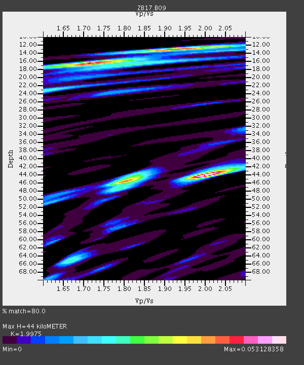
| Thickness Estimate: | 44 km |
| Thickness StdDev: | 12 km |
| Vp/Vs Estimate: | 2.00 |
| Vp/Vs StdDev: | 0.10 |
| Vs Estimate: | 2.002 km/s |
| Poisson's Ratio: | 0.33 |
| Peak Value: | 0.05 |
| Assumed Vp: | 3.999 km/s |
| Ps Weight: | 0.33333334 |
| PpPs Weight: | 0.33333334 |
| PsPs Weight: | 0.33333328 |
| Residual Complexity: | 0.842 |
| Nearby stations H: | +- |
| (2.0 deg) Vp/Vs: | +- |
0 with match > 90% ( 0.0 %) and 3 with match > 80% ( 21.428572 %) out of 14.
Download stack as xyz text file.
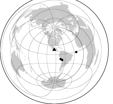
Azimuth Distribution of Events:
Prior Results for this Station
| Study | Thickness | Vp/Vs | Vp | Vs | Poissons Ratio | Extra |
| EARS | 44 km | 2.00 | 3.999 km/s | 2.002 km/s | 0.33 | |
| Crust2.0 | 14 km | 2.17 | 3.999 km/s | 1.84 km/s | 0.37 | A3,normal oceanic 2 km seds. |
| Global Maxima | 44 km | 2.00 | 3.999 km/s | 2.002 km/s | 0.33 | amp=0.053128358 |
| Local Maxima 1 | 16 km | 1.72 | 3.999 km/s | 2.321 km/s | 0.25 | amp=0.044067558 |
| Local Maxima 2 | 46 km | 1.80 | 3.999 km/s | 2.221 km/s | 0.28 | amp=0.040293552 |
| Local Maxima 3 | 13 km | 1.96 | 3.999 km/s | 2.04 km/s | 0.32 | amp=0.034091298 |
| Local Maxima 4 | 23 km | 1.61 | 3.999 km/s | 2.491 km/s | 0.18 | amp=0.020511413 |
| Predicted Arrivals for vertical incidence (zero ray parameter) | |
| Ps | 10.98 SECOND |
| PpPs | 32.98 SECOND |
| PsPs/PpSs | 43.96 SECOND |
Events Processed for this Station
Download zip of receiver functions as SAC
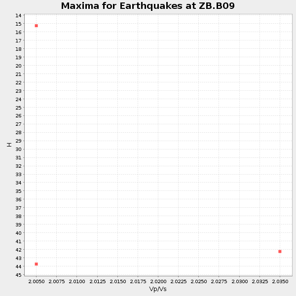
Plot maxima for each earthquake.
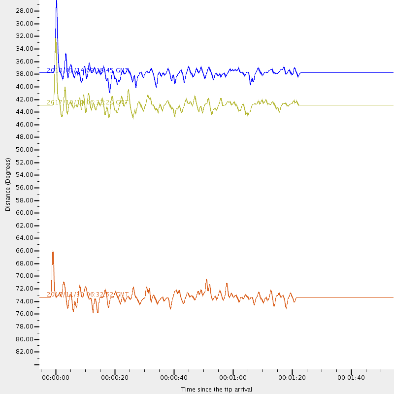
Events Used in the Stack
(3 events)| Radial Match | Distance | Baz | FERegion | Time | Lat/Lon | Depth | Magnitude |
| 88.37977 | 42.8 deg | 142.01 deg | Northern Chile | 2017/10/10 06:32:20 GMT | (-18.5, -69.6) | 82 km | 6.3 Mww |
| 87.33738 | 73.3 deg | 96.059 deg | Central Mid-Atlantic Ridge | 2017/11/30 06:32:52 GMT | (-1.1, -23.5) | 10 km | 6.5 Mi |
| 85.42317 | 37.7 deg | 145.563 deg | Near Coast Of Peru | 2018/01/14 09:18:45 GMT | (-15.8, -74.7) | 36 km | 7.1 mww |
Losers
(11 events)| Radial Match | Distance | Baz | FERegion | Time | Lat/Lon | Depth | Magnitude | Reason |
| 79.51094 | 76.0 deg | 320.937 deg | Rat Islands, Aleutian Islands | 2017/10/08 22:34:33 GMT | (52.4, 176.8) | 112 km | 6.6 mww | |
| 69.49916 | 73.7 deg | 320.796 deg | Andreanof Islands, Aleutian Is. | 2018/02/08 11:04:01 GMT | (52.6, -179.5) | 211 km | 5.6 Mww | |
| 68.246 | 76.9 deg | 1.559 deg | North Of Franz Josef Land | 2017/10/28 19:11:01 GMT | (86.9, 55.1) | 10 km | 6.0 Mww | |
| 68.16632 | 88.1 deg | 251.126 deg | Fiji Islands Region | 2017/11/07 09:01:39 GMT | (-17.7, -178.5) | 555 km | 5.7 Mww | |
| 60.241062 | 58.1 deg | 169.646 deg | West Chile Rise | 2017/11/10 12:01:34 GMT | (-41.5, -84.1) | 10 km | 5.8 Mww | |
| 54.657413 | 41.7 deg | 206.192 deg | Southern East Pacific Rise | 2017/12/19 05:35:29 GMT | (-21.9, -114.2) | 10 km | 5.6 mb | |
| 50.541832 | 89.6 deg | 248.215 deg | Fiji Islands Region | 2018/02/11 16:38:14 GMT | (-20.9, -179.1) | 631 km | 5.5 Mww | |
| 48.553 | 77.6 deg | 17.718 deg | Norwegian Sea | 2017/11/28 13:15:46 GMT | (72.6, 3.2) | 10 km | 5.6 Mww | |
| 36.708237 | 91.4 deg | 126.271 deg | Tristan Da Cunha Region | 2017/10/06 17:41:23 GMT | (-35.3, -15.6) | 10 km | 5.5 Mwb | |
| 35.63731 | 56.9 deg | 159.349 deg | Off Coast Of Central Chile | 2018/02/08 21:19:23 GMT | (-37.4, -74.0) | 10 km | 5.6 Mww | |
| 15.521561 | 44.1 deg | 142.653 deg | Northern Chile | 2017/11/17 16:45:46 GMT | (-19.8, -69.2) | 97 km | 5.0 Mww |

