
Station ZD D05 - WHOI OBS ID S67
Network: ZD07 - Seismcity of Quebrada-Discovery-gofur- Transforms ( QDG)
Nearby stations (2 deg radius)
| Station | Name | (Lat, Lon) | Start / End | Elevation |
| D05 | WHOI OBS ID S67 | (-4.09, -104.23) | 2007-12-26 / 2009-01-21 | -3088.0 m |
| Crust2 Type: | A0,normal oceanic, 0.07 km seds. |
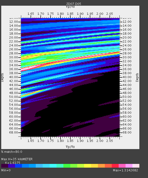
| Thickness Estimate: | 35 km |
| Thickness StdDev: | 4.3 km |
| Vp/Vs Estimate: | 1.64 |
| Vp/Vs StdDev: | 0.12 |
| Vs Estimate: | 2.589 km/s |
| Poisson's Ratio: | 0.20 |
| Peak Value: | 1.31 |
| Assumed Vp: | 4.24 km/s |
| Ps Weight: | 0.33333334 |
| PpPs Weight: | 0.33333334 |
| PsPs Weight: | 0.33333328 |
| Residual Complexity: | 0.878 |
| Nearby stations H: | +- |
| (2.0 deg) Vp/Vs: | +- |
1 with match > 90% ( 6.25 %) and 2 with match > 80% ( 12.5 %) out of 16.
Download stack as xyz text file.
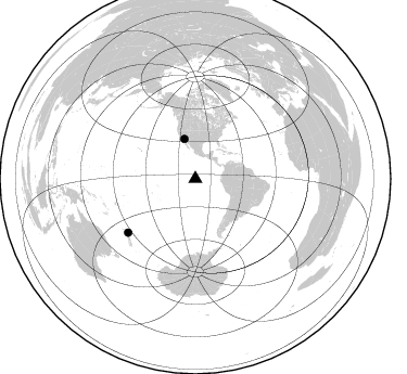
Azimuth Distribution of Events:
Prior Results for this Station
| Study | Thickness | Vp/Vs | Vp | Vs | Poissons Ratio | Extra |
| EARS | 35 km | 1.64 | 4.24 km/s | 2.589 km/s | 0.20 | |
| Crust2.0 | 12 km | 2.19 | 4.24 km/s | 1.94 km/s | 0.37 | A0,normal oceanic, 0.07 km seds. |
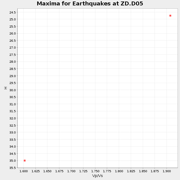
| Global Maxima | 35 km | 1.64 | 4.24 km/s | 2.589 km/s | 0.20 | amp=1.3142682 |
| Local Maxima 1 | 29 km | 1.97 | 4.24 km/s | 2.152 km/s | 0.33 | amp=1.2388589 |
| Local Maxima 2 | 29 km | 1.65 | 4.24 km/s | 2.566 km/s | 0.21 | amp=1.1062512 |
| Local Maxima 3 | 32 km | 1.81 | 4.24 km/s | 2.349 km/s | 0.28 | amp=1.080706 |
| Local Maxima 4 | 48 km | 1.65 | 4.24 km/s | 2.574 km/s | 0.21 | amp=1.0465032 |
| Predicted Arrivals for vertical incidence (zero ray parameter) | |
| Ps | 5.26 SECOND |
| PpPs | 21.77 SECOND |
| PsPs/PpSs | 27.03 SECOND |
Events Processed for this Station
Download zip of receiver functions as SAC
Plot maxima for each earthquake.
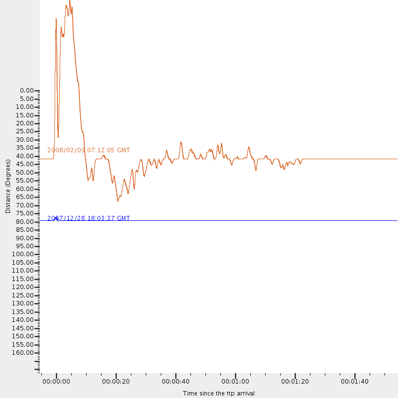
Events Used in the Stack
(2 events)| Radial Match | Distance | Baz | FERegion | Time | Lat/Lon | Depth | Magnitude |
| 97.44041 | 79.2 deg | 231.462 deg | North Island, New Zealand | 2007/12/28 18:03:37 GMT | (-38.8, 176.3) | 80 km | 5.5 ML |
| 82.76442 | 37.8 deg | 344.633 deg | Calif.-Baja Calif. Border Region | 2008/02/09 07:12:05 GMT | (32.5, -115.3) | 2.9 km | 5.5 ML |
Losers
(14 events)| Radial Match | Distance | Baz | FERegion | Time | Lat/Lon | Depth | Magnitude | Reason |
| 69.418 | 67.8 deg | 146.517 deg | South Atlantic Ocean | 2008/02/20 12:49:44 GMT | (-53.0, -46.5) | 10 km | 5.6 MB | |
| 53.290363 | 38.7 deg | 119.959 deg | Chile-Bolivia Border Region | 2008/01/04 01:26:31 GMT | (-21.6, -68.6) | 118 km | 5.5 MB | |
| 48.13569 | 31.4 deg | 192.076 deg | Southern East Pacific Rise | 2008/01/21 12:24:27 GMT | (-34.9, -111.9) | 10 km | 5.6 MB, 5.4 MS, 5.8 MW, 5.7 MW | |
| 44.898113 | 69.2 deg | 203.142 deg | Pacific-Antarctic Ridge | 2008/01/05 19:55:31 GMT | (-62.1, -155.7) | 10 km | 5.7 MW | |
| 42.236084 | 97.1 deg | 323.647 deg | Near East Coast Of Kamchatka | 2008/03/01 18:51:26 GMT | (53.9, 159.3) | 112 km | 5.5 MB | |
| 37.51796 | 70.7 deg | 255.33 deg | Tonga Islands | 2008/01/22 07:55:48 GMT | (-15.3, -175.3) | 6.0 km | 5.6 MB, 6.0 MS, 6.0 MW, 6.0 MW | |
| 35.29659 | 36.9 deg | 118.512 deg | Near Coast Of Northern Chile | 2008/02/04 17:01:30 GMT | (-20.2, -70.0) | 44 km | 6.0 MB, 6.2 MS, 6.3 MW, 6.3 MW | |
| 33.719948 | 63.8 deg | 76.074 deg | Northern Mid-Atlantic Ridge | 2008/02/08 09:38:14 GMT | (10.7, -41.9) | 9.0 km | 6.9 MW, 6.4 MB, 6.9 MW, 6.9 MS | |
| 33.415745 | 81.6 deg | 147.231 deg | South Sandwich Islands Region | 2008/02/23 15:57:19 GMT | (-57.3, -23.4) | 10 km | 6.2 MB, 6.7 MS, 6.7 MW, 6.7 MW | |
| 28.271305 | 46.1 deg | 348.837 deg | Nevada | 2008/02/21 14:16:02 GMT | (41.2, -114.9) | 6.7 km | 6.0 MW, 5.7 MB, 5.8 MS, 6.0 MW | |
| 26.65805 | 92.0 deg | 208.252 deg | Balleny Islands Region | 2008/02/15 22:00:55 GMT | (-61.3, 154.2) | 10 km | 5.7 MW | |
| 17.728752 | 80.9 deg | 150.861 deg | South Sandwich Islands Region | 2008/02/10 12:22:02 GMT | (-60.8, -25.6) | 8.0 km | 6.6 MW, 6.4 MB, 6.5 MW, 6.5 MS | |
| 17.662386 | 74.9 deg | 248.449 deg | Fiji Islands Region | 2008/01/15 17:52:15 GMT | (-22.0, -179.5) | 598 km | 5.8 MB, 6.5 MW, 6.5 MW | |
| 9.964446 | 31.1 deg | 187.531 deg | Southern East Pacific Rise | 2008/02/29 02:38:29 GMT | (-35.1, -109.0) | 10 km | 5.7 MW, 5.7 MW |
