
Station ZD G10 - WHOI OBS ID S83
Network: ZD07 - Seismcity of Quebrada-Discovery-gofur- Transforms ( QDG)
Nearby stations (2 deg radius)
| Station | Name | (Lat, Lon) | Start / End | Elevation |
| G10 | WHOI OBS ID S83 | (-4.59, -105.87) | 2007-12-24 / 2009-01-23 | -3395.0 m |
| Crust2 Type: | A0,normal oceanic, 0.07 km seds. |
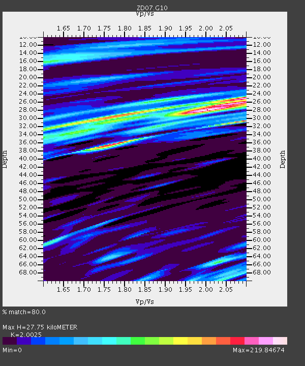
| Thickness Estimate: | 28 km |
| Thickness StdDev: | 17 km |
| Vp/Vs Estimate: | 2.00 |
| Vp/Vs StdDev: | 0.11 |
| Vs Estimate: | 2.117 km/s |
| Poisson's Ratio: | 0.33 |
| Peak Value: | 219.85 |
| Assumed Vp: | 4.24 km/s |
| Ps Weight: | 0.33333334 |
| PpPs Weight: | 0.33333334 |
| PsPs Weight: | 0.33333328 |
| Residual Complexity: | 0.805 |
| Nearby stations H: | +- |
| (2.0 deg) Vp/Vs: | +- |
1 with match > 90% ( 3.4482758 %) and 2 with match > 80% ( 6.8965516 %) out of 29.
Download stack as xyz text file.
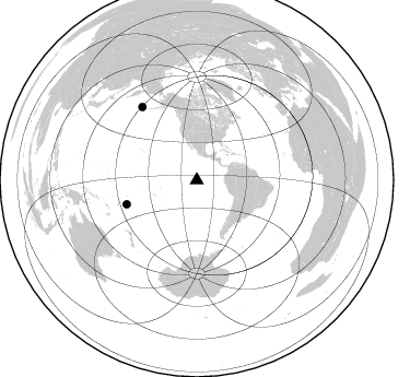
Azimuth Distribution of Events:
Prior Results for this Station
| Study | Thickness | Vp/Vs | Vp | Vs | Poissons Ratio | Extra |
| EARS | 28 km | 2.00 | 4.24 km/s | 2.117 km/s | 0.33 | |
| Crust2.0 | 12 km | 2.19 | 4.24 km/s | 1.94 km/s | 0.37 | A0,normal oceanic, 0.07 km seds. |
| Global Maxima | 28 km | 2.00 | 4.24 km/s | 2.117 km/s | 0.33 | amp=219.84674 |
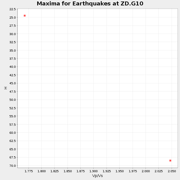
| Local Maxima 1 | 36 km | 1.78 | 4.24 km/s | 2.385 km/s | 0.27 | amp=183.15218 |
| Local Maxima 2 | 30 km | 2.09 | 4.24 km/s | 2.026 km/s | 0.35 | amp=172.76147 |
| Local Maxima 3 | 29 km | 1.81 | 4.24 km/s | 2.339 km/s | 0.28 | amp=164.23112 |
| Local Maxima 4 | 25 km | 2.09 | 4.24 km/s | 2.026 km/s | 0.35 | amp=140.46602 |
| Predicted Arrivals for vertical incidence (zero ray parameter) | |
| Ps | 6.56 SECOND |
| PpPs | 19.65 SECOND |
| PsPs/PpSs | 26.21 SECOND |
Events Processed for this Station
Download zip of receiver functions as SAC
Plot maxima for each earthquake.
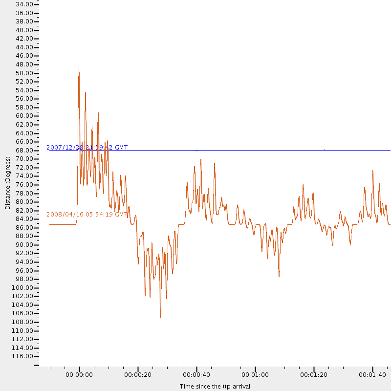
Events Used in the Stack
(2 events)| Radial Match | Distance | Baz | FERegion | Time | Lat/Lon | Depth | Magnitude |
| 97.45617 | 67.9 deg | 251.041 deg | Tonga Islands | 2007/12/28 21:59:42 GMT | (-19.4, -174.0) | 35 km | 5.6 MW |
| 89.72319 | 83.4 deg | 323.293 deg | Andreanof Islands, Aleutian Is. | 2008/04/16 05:54:19 GMT | (51.9, -179.2) | 13 km | 6.1 MB, 6.5 MS, 6.6 MW, 6.6 MW |
Losers
(27 events)| Radial Match | Distance | Baz | FERegion | Time | Lat/Lon | Depth | Magnitude | Reason |
| 87.96126 | 73.0 deg | 249.037 deg | Fiji Islands Region | 2008/02/01 12:10:06 GMT | (-21.5, -179.4) | 604 km | 5.6 MB, 6.0 MW, 6.0 MW | |
| 83.91132 | 89.4 deg | 214.324 deg | Macquarie Island Region | 2008/04/12 00:30:12 GMT | (-55.7, 158.5) | 16 km | 6.8 MB, 7.1 MS, 7.1 MW, 7.1 MW | |
| 75.19031 | 67.7 deg | 250.961 deg | Tonga Islands | 2007/12/30 06:24:01 GMT | (-19.5, -173.8) | 30 km | 5.7 MW | |
| 74.795265 | 86.8 deg | 125.16 deg | Southern Mid-Atlantic Ridge | 2008/04/27 14:35:29 GMT | (-35.5, -16.6) | 10 km | 5.6 MW | |
| 71.01948 | 71.7 deg | 240.837 deg | Kermadec Islands, New Zealand | 2008/03/18 08:22:47 GMT | (-29.3, -177.4) | 25 km | 5.8 MB, 6.1 MS, 6.2 MW, 6.2 MW | |
| 67.82102 | 84.4 deg | 250.502 deg | Vanuatu Islands | 2008/04/10 01:17:34 GMT | (-19.9, 168.5) | 35 km | 5.5 MW | |
| 65.92126 | 71.9 deg | 244.262 deg | South Of Fiji Islands | 2008/03/30 17:10:07 GMT | (-26.0, -177.9) | 155 km | 5.5 MW | |
| 62.532818 | 83.5 deg | 323.236 deg | Andreanof Islands, Aleutian Is. | 2008/04/15 22:59:51 GMT | (51.9, -179.4) | 10 km | 6.1 MB, 6.4 MS, 6.4 MW, 6.4 MW | |
| 60.964592 | 42.0 deg | 128.271 deg | Chile-Argentina Border Region | 2008/03/10 09:43:01 GMT | (-28.3, -69.3) | 90 km | 5.6 MB, 5.6 MW | |
| 60.046555 | 55.3 deg | 201.008 deg | Pacific-Antarctic Ridge | 2008/03/17 19:06:12 GMT | (-54.3, -136.1) | 10 km | 5.6 MW, 5.0 MB | |
| 57.87868 | 30.0 deg | 43.308 deg | North Of Honduras | 2008/03/27 09:42:57 GMT | (17.2, -84.8) | 10 km | 5.6 MW, 5.1 MS, 5.4 MB, 5.6 MW | |
| 56.24718 | 90.7 deg | 208.403 deg | Balleny Islands Region | 2008/02/15 22:00:55 GMT | (-61.3, 154.2) | 10 km | 5.7 MW | |
| 53.96192 | 40.0 deg | 118.021 deg | Chile-Bolivia Border Region | 2008/02/16 14:45:11 GMT | (-21.3, -68.4) | 130 km | 6.1 MW, 5.6 MB, 6.1 MW | |
| 52.71331 | 82.4 deg | 323.573 deg | Andreanof Islands, Aleutian Is. | 2008/05/02 01:33:37 GMT | (51.9, -177.5) | 14 km | 6.3 MB, 6.8 MS, 6.6 MW, 6.6 MW | |
| 48.32156 | 59.3 deg | 202.17 deg | Pacific-Antarctic Ridge | 2008/03/26 06:29:50 GMT | (-56.7, -141.9) | 10 km | 5.5 MW | |
| 47.24091 | 75.4 deg | 244.159 deg | South Of Fiji Islands | 2008/04/10 13:07:24 GMT | (-26.3, 178.2) | 644 km | 5.5 MW | |
| 46.89982 | 68.3 deg | 145.951 deg | South Atlantic Ocean | 2008/02/29 16:10:28 GMT | (-53.0, -46.4) | 10 km | 5.5 MB | |
| 45.227818 | 84.0 deg | 249.995 deg | Loyalty Islands | 2008/05/06 12:42:17 GMT | (-20.5, 168.8) | 35 km | 5.5 MW | |
| 43.39694 | 38.3 deg | 117.157 deg | Northern Chile | 2008/03/01 19:51:59 GMT | (-20.3, -69.9) | 37 km | 5.7 MB, 5.1 MS, 5.7 MW, 5.6 MW | |
| 38.58619 | 84.0 deg | 250.135 deg | Loyalty Islands | 2008/04/10 04:29:35 GMT | (-20.3, 168.9) | 35 km | 5.5 MW | |
| 37.24873 | 79.4 deg | 146.058 deg | South Sandwich Islands Region | 2008/04/14 09:45:19 GMT | (-56.0, -28.0) | 140 km | 6.0 MB, 6.0 MW, 6.0 MW | |
| 36.930824 | 82.1 deg | 147.118 deg | South Sandwich Islands Region | 2008/02/23 15:57:19 GMT | (-57.3, -23.4) | 10 km | 6.2 MB, 6.7 MS, 6.7 MW, 6.7 MW | |
| 35.477818 | 83.2 deg | 323.659 deg | Andreanof Islands, Aleutian Is. | 2008/03/22 21:24:11 GMT | (52.2, -178.7) | 132 km | 5.8 MB, 6.2 MW, 6.1 MW | |
| 35.34234 | 66.6 deg | 255.418 deg | Samoa Islands Region | 2008/04/04 04:03:01 GMT | (-15.3, -172.8) | 34 km | 5.5 MW | |
| 34.297596 | 68.2 deg | 145.869 deg | South Atlantic Ocean | 2008/02/20 12:11:20 GMT | (-52.9, -46.5) | 10 km | 5.5 MB | |
| 32.289703 | 69.4 deg | 251.946 deg | Tonga Islands | 2008/04/16 00:35:48 GMT | (-18.6, -175.7) | 10 km | 5.6 MB, 6.3 MS, 6.3 MW, 6.3 MW | |
| 30.466719 | 39.1 deg | 116.365 deg | Chile-Bolivia Border Region | 2008/03/24 20:39:07 GMT | (-20.0, -69.0) | 120 km | 5.7 MB, 6.2 MW, 6.1 MW |
