
Station ZU NZ07 - SIO_OBS_ID: S115
Network: ZU09 - Marine Observations of Anisotropy
Nearby stations (2 deg radius)
| Station | Name | (Lat, Lon) | Start / End | Elevation |
| NZ07 | SIO_OBS_ID: S115 | (-40.25, 169.00) | 2009-02-03 / 2010-12-31 | -852.0 m |
| Crust2 Type: | W1,oceanic plateau with cont. crust, 0.25 km seds. |
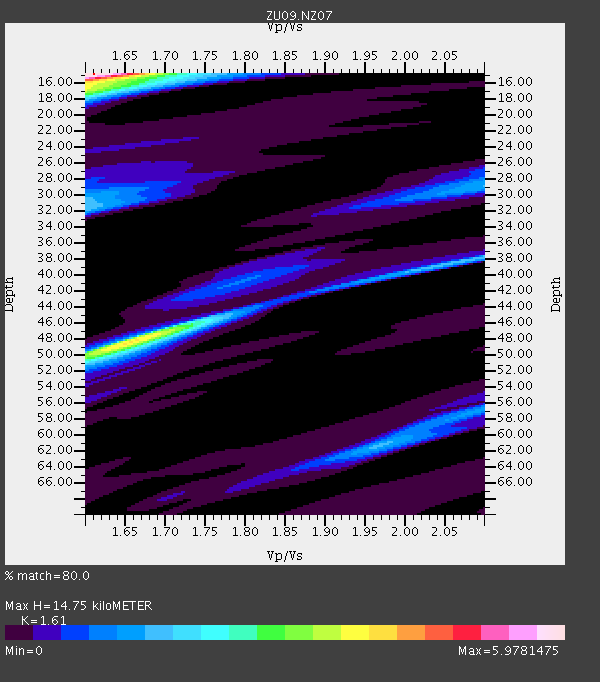
| Thickness Estimate: | 15 km |
| Thickness StdDev: | 9.9 km |
| Vp/Vs Estimate: | 1.61 |
| Vp/Vs StdDev: | 0.18 |
| Vs Estimate: | 3.915 km/s |
| Poisson's Ratio: | 0.19 |
| Peak Value: | 5.98 |
| Assumed Vp: | 6.303 km/s |
| Ps Weight: | 0.33333334 |
| PpPs Weight: | 0.33333334 |
| PsPs Weight: | 0.33333328 |
| Residual Complexity: | 0.774 |
| Nearby stations H: | +- |
| (2.0 deg) Vp/Vs: | +- |
2 with match > 90% ( 3.7735848 %) and 3 with match > 80% ( 5.6603775 %) out of 53.
Download stack as xyz text file.
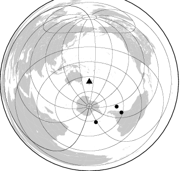
Azimuth Distribution of Events:
Prior Results for this Station
| Study | Thickness | Vp/Vs | Vp | Vs | Poissons Ratio | Extra |
| EARS | 15 km | 1.61 | 6.303 km/s | 3.915 km/s | 0.19 | |
| Crust2.0 | 20 km | 1.81 | 6.303 km/s | 3.487 km/s | 0.28 | W1,oceanic plateau with cont. crust, 0.25 km seds. |
| Global Maxima | 15 km | 1.61 | 6.303 km/s | 3.915 km/s | 0.19 | amp=5.9781475 |
| Local Maxima 1 | 48 km | 1.66 | 6.303 km/s | 3.802 km/s | 0.21 | amp=3.908737 |
| Local Maxima 2 | 17 km | 1.60 | 6.303 km/s | 3.933 km/s | 0.18 | amp=3.1044312 |
| Local Maxima 3 | 32 km | 1.60 | 6.303 km/s | 3.939 km/s | 0.18 | amp=1.7695721 |
| Local Maxima 4 | 61 km | 1.97 | 6.303 km/s | 3.207 km/s | 0.33 | amp=1.5725895 |
| Predicted Arrivals for vertical incidence (zero ray parameter) | |
| Ps | 1.43 SECOND |
| PpPs | 6.11 SECOND |
| PsPs/PpSs | 7.54 SECOND |
Events Processed for this Station
Download zip of receiver functions as SAC
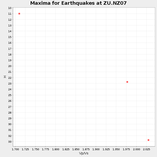
Plot maxima for each earthquake.
Events Used in the Stack
(3 events)| Radial Match | Distance | Baz | FERegion | Time | Lat/Lon | Depth | Magnitude |
| 92.53373 | 89.9 deg | 133.5 deg | Mendoza Province, Argentina | 2009/05/08 13:44:53 GMT | (-32.1, -69.7) | 112 km | 5.6 MB, 5.4 MW |
| 90.53784 | 83.1 deg | 170.621 deg | South Sandwich Islands Region | 2009/04/04 18:39:17 GMT | (-56.0, -27.7) | 87 km | 5.5 MW, 5.5 MB |
| 85.78694 | 75.0 deg | 132.162 deg | West Chile Rise | 2009/06/10 23:13:21 GMT | (-41.7, -84.0) | 10 km | 5.7 MB, 5.2 MS, 5.7 MW, 5.6 MW |
Losers
(50 events)| Radial Match | Distance | Baz | FERegion | Time | Lat/Lon | Depth | Magnitude | Reason |
| 99.99855 | 58.4 deg | 332.618 deg | Mariana Islands | 2009/06/19 15:06:24 GMT | (14.1, 145.2) | 114 km | 5.5 MB, 5.5 MW | |
| 99.93021 | 84.6 deg | 189.821 deg | Bouvet Island Region | 2009/06/16 20:05:56 GMT | (-54.4, 5.9) | 10 km | 5.8 MB, 5.9 MS, 6.1 MW, 6.1 MW | |
| 98.36916 | 68.5 deg | 282.107 deg | Southern Sumatra, Indonesia | 2009/06/20 09:21:23 GMT | (-5.0, 103.0) | 46 km | 5.8 MB, 5.4 MW, 5.4 MW | |
| 97.1542 | 58.6 deg | 308.037 deg | Talaud Islands, Indonesia | 2009/02/11 17:44:04 GMT | (3.9, 126.6) | 29 km | 5.5 MB | |
| 94.1334 | 82.4 deg | 339.337 deg | Near East Coast Of Honshu, Japan | 2009/06/23 07:37:17 GMT | (38.8, 142.4) | 37 km | 5.7 MB, 5.0 MS, 5.6 MW, 5.6 MW | |
| 89.05909 | 49.2 deg | 300.253 deg | Banda Sea | 2009/02/26 21:09:30 GMT | (-7.5, 127.8) | 145 km | 5.5 MW, 5.4 MB, 5.5 MW | |
| 88.14614 | 45.3 deg | 133.097 deg | Southern East Pacific Rise | 2009/05/07 22:28:52 GMT | (-55.7, -124.6) | 10 km | 5.5 MW | |
| 85.23728 | 58.6 deg | 307.797 deg | Talaud Islands, Indonesia | 2009/02/13 21:26:36 GMT | (3.8, 126.5) | 32 km | 5.5 MB, 5.2 MW | |
| 84.96211 | 84.9 deg | 341.114 deg | Hokkaido, Japan Region | 2009/06/05 03:30:33 GMT | (41.8, 143.4) | 29 km | 6.0 MB, 6.3 MS, 6.4 MW, 6.4 MW | |
| 84.26192 | 30.0 deg | 346.57 deg | Solomon Islands | 2009/05/01 06:03:05 GMT | (-10.8, 162.2) | 21 km | 5.9 MB, 5.6 MS, 5.9 MW, 5.9 MW | |
| 81.75551 | 51.3 deg | 295.536 deg | Flores Region, Indonesia | 2009/03/07 16:27:20 GMT | (-8.4, 123.6) | 172 km | 5.6 MB | |
| 80.78737 | 58.5 deg | 308.028 deg | Talaud Islands, Indonesia | 2009/02/13 12:37:51 GMT | (3.8, 126.7) | 35 km | 5.5 MB, 5.2 MS, 5.6 MW, 5.3 MW | |
| 80.0872 | 57.7 deg | 333.692 deg | South Of Mariana Islands | 2009/02/24 05:57:59 GMT | (13.8, 146.3) | 5.0 km | 5.7 MB, 5.7 MS, 5.9 MW, 5.8 MW | |
| 79.03924 | 58.8 deg | 307.961 deg | Talaud Islands, Indonesia | 2009/02/12 17:46:05 GMT | (4.0, 126.5) | 44 km | 5.7 MB, 5.3 MS, 5.5 MW, 5.5 MW | |
| 78.78648 | 44.2 deg | 131.927 deg | Southern East Pacific Rise | 2009/06/09 22:42:38 GMT | (-55.1, -126.7) | 10 km | 5.6 MW, 5.6 MW | |
| 78.460846 | 47.2 deg | 302.23 deg | Tanimbar Islands Reg., Indonesia | 2009/04/03 13:37:58 GMT | (-8.0, 130.2) | 35 km | 5.6 MW, 5.2 MS, 5.1 MB, 5.6 MW | |
| 76.84674 | 83.1 deg | 198.785 deg | South Of Africa | 2009/02/18 03:07:50 GMT | (-53.0, 20.9) | 10 km | 5.6 MB, 5.6 MS, 5.9 MW, 5.9 MW | |
| 76.38964 | 46.8 deg | 316.938 deg | Near North Coast Of Irian Jaya | 2009/03/10 17:42:14 GMT | (-1.9, 139.1) | 18 km | 5.5 MB, 5.2 MS, 5.5 MW, 5.4 MW | |
| 75.941216 | 85.1 deg | 91.175 deg | Central East Pacific Rise | 2009/05/24 09:57:11 GMT | (-4.1, -104.0) | 6.0 km | 5.6 MW, 5.5 MW | |
| 75.81698 | 76.8 deg | 245.237 deg | Mid-Indian Ridge | 2009/03/26 06:14:22 GMT | (-27.5, 73.3) | 10 km | 5.7 MW, 5.4 MS, 5.4 MB, 5.6 MW | |
| 75.32632 | 59.8 deg | 123.555 deg | Southern East Pacific Rise | 2009/05/29 15:26:25 GMT | (-43.8, -107.2) | 10 km | 5.6 MB | |
| 74.69366 | 79.9 deg | 328.24 deg | Kyushu, Japan | 2009/04/05 09:36:26 GMT | (32.0, 131.4) | 26 km | 5.8 MB, 5.4 MS, 5.8 MW, 5.8 MW | |
| 74.050934 | 59.3 deg | 309.441 deg | Philippine Islands Region | 2009/04/04 05:31:55 GMT | (5.1, 127.2) | 48 km | 6.1 MB, 5.8 MS, 6.3 MW, 6.2 MW | |
| 73.62019 | 77.1 deg | 283.037 deg | Northern Sumatra, Indonesia | 2009/02/24 12:13:15 GMT | (1.4, 97.2) | 35 km | 5.6 MB, 5.7 MS, 5.7 MW, 5.5 MW | |
| 73.5282 | 58.9 deg | 308.575 deg | Talaud Islands, Indonesia | 2009/04/23 12:16:19 GMT | (4.4, 126.8) | 52 km | 5.5 MW | |
| 72.90774 | 61.7 deg | 311.006 deg | Mindanao, Philippines | 2009/05/21 05:53:53 GMT | (7.9, 126.9) | 14 km | 5.5 MB, 5.3 MS, 5.7 MW, 5.7 MW | |
| 71.58987 | 89.6 deg | 350.726 deg | Kuril Islands | 2009/04/14 03:04:27 GMT | (48.8, 154.9) | 44 km | 5.5 MW | |
| 70.294464 | 81.9 deg | 182.539 deg | Southern Mid-Atlantic Ridge | 2009/04/08 06:26:54 GMT | (-58.1, -6.3) | 10 km | 5.5 MW, 5.6 MW | |
| 67.06308 | 80.2 deg | 338.717 deg | Off East Coast Of Honshu, Japan | 2009/05/09 19:34:33 GMT | (36.5, 142.6) | 27 km | 5.5 MB | |
| 65.19566 | 75.2 deg | 321.971 deg | Southeast Of Ryukyu Islands | 2009/07/06 22:35:05 GMT | (24.9, 128.0) | 10 km | 6.1 MB, 5.3 MS, 5.7 MW, 5.7 MW | |
| 59.6421 | 37.5 deg | 334.428 deg | New Ireland Region, P.N.G. | 2009/06/23 14:19:17 GMT | (-5.2, 153.7) | 65 km | 5.5 MB | |
| 59.331387 | 87.3 deg | 347.84 deg | Kuril Islands | 2009/04/18 19:17:58 GMT | (46.0, 151.4) | 35 km | 6.3 MB, 6.3 MS, 6.6 MW, 6.4 MW | |
| 59.177597 | 73.8 deg | 313.197 deg | Philippine Islands Region | 2009/02/26 12:32:52 GMT | (19.0, 121.3) | 38 km | 5.5 MW | |
| 58.173363 | 85.3 deg | 342.443 deg | Hokkaido, Japan Region | 2009/04/28 11:21:18 GMT | (42.7, 144.9) | 15 km | 5.9 MB | |
| 54.414642 | 75.5 deg | 283.238 deg | Northern Sumatra, Indonesia | 2009/02/23 05:56:31 GMT | (0.5, 98.5) | 35 km | 5.8 MB, 5.1 MS, 5.4 MW, 5.4 MW | |
| 53.23333 | 84.9 deg | 210.406 deg | Prince Edward Islands Region | 2009/06/04 17:25:25 GMT | (-45.8, 35.1) | 16 km | 5.5 MB, 5.7 MS, 6.0 MW, 6.0 MW | |
| 49.141605 | 92.1 deg | 7.923 deg | Andreanof Islands, Aleutian Is. | 2009/03/30 12:07:28 GMT | (51.5, -178.3) | 31 km | 6.0 MB, 5.5 MS, 5.7 MW, 5.7 MW | |
| 47.132824 | 58.5 deg | 307.822 deg | Talaud Islands, Indonesia | 2009/02/22 17:45:22 GMT | (3.7, 126.6) | 32 km | 5.9 MB, 5.7 MS, 6.0 MW, 6.0 MW | |
| 40.06226 | 71.7 deg | 281.759 deg | Southern Sumatra, Indonesia | 2009/04/15 17:47:25 GMT | (-3.1, 100.4) | 6.0 km | 5.6 MS, 5.4 MB, 5.8 MW, 5.5 MW | |
| 36.32485 | 94.6 deg | 259.252 deg | Chagos Archipelago Region | 2009/04/05 12:56:14 GMT | (-5.3, 68.6) | 10 km | 5.6 MW, 5.6 MW | |
| 34.288254 | 92.1 deg | 129.897 deg | Near Coast Of Northern Chile | 2009/02/06 02:58:35 GMT | (-28.0, -71.1) | 52 km | 5.5 MB | |
| 32.12019 | 58.7 deg | 307.852 deg | Talaud Islands, Indonesia | 2009/02/11 19:01:55 GMT | (3.8, 126.5) | 35 km | 5.5 MB | |
| 31.321085 | 58.6 deg | 308.298 deg | Talaud Islands, Indonesia | 2009/02/12 01:25:25 GMT | (4.0, 126.8) | 16 km | 5.5 MB, 5.2 MS, 5.6 MW, 5.5 MW | |
| 31.143818 | 92.0 deg | 131.509 deg | Chile-Argentina Border Region | 2009/02/16 02:22:50 GMT | (-29.1, -69.8) | 75 km | 5.7 MB, 5.6 MD | |
| 30.532915 | 96.4 deg | 69.942 deg | Revilla Gigedo Islands Region | 2009/06/03 21:37:37 GMT | (19.6, -109.2) | 6.0 km | 5.6 MW, 5.1 MS, 5.2 MB, 5.5 MW | |
| 26.034315 | 59.4 deg | 302.194 deg | Minahassa Peninsula, Sulawesi | 2009/06/28 14:19:30 GMT | (1.4, 122.2) | 37 km | 5.5 MB, 5.1 MS, 5.7 MW, 5.5 MW | |
| 25.262405 | 58.7 deg | 308.019 deg | Talaud Islands, Indonesia | 2009/02/12 00:03:00 GMT | (3.9, 126.6) | 35 km | 5.5 MB | |
| 22.904247 | 57.1 deg | 330.248 deg | South Of Mariana Islands | 2009/02/12 13:41:43 GMT | (12.1, 143.8) | 40 km | 5.5 MB | |
| 22.740211 | 71.6 deg | 281.514 deg | Southern Sumatra, Indonesia | 2009/04/16 19:55:24 GMT | (-3.3, 100.3) | 7.7 km | 5.5 MW | |
| 22.09241 | 92.4 deg | 251.665 deg | Mid-Indian Ridge | 2009/05/12 12:38:30 GMT | (-12.4, 65.1) | 10 km | 5.5 MB, 5.3 MS, 5.8 MW, 5.8 MW |
