
Station ZU NZ21 - SIO_OBS_ID: S080
Network: ZU09 - Marine Observations of Anisotropy
Nearby stations (2 deg radius)
| Station | Name | (Lat, Lon) | Start / End | Elevation |
| NZ21 | SIO_OBS_ID: S080 | (-39.50, 170.00) | 2009-02-08 / 2010-12-31 | -676.0 m |
| Crust2 Type: | S2,continental slope, margin, transition 2 km seds. |
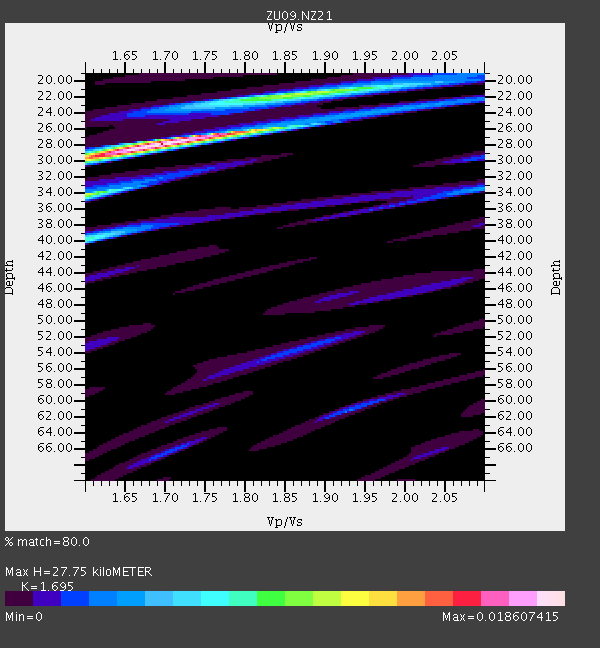
| Thickness Estimate: | 28 km |
| Thickness StdDev: | 13 km |
| Vp/Vs Estimate: | 1.70 |
| Vp/Vs StdDev: | 0.16 |
| Vs Estimate: | 3.568 km/s |
| Poisson's Ratio: | 0.23 |
| Peak Value: | 0.02 |
| Assumed Vp: | 6.048 km/s |
| Ps Weight: | 0.33333334 |
| PpPs Weight: | 0.33333334 |
| PsPs Weight: | 0.33333328 |
| Residual Complexity: | 0.537 |
| Nearby stations H: | +- |
| (2.0 deg) Vp/Vs: | +- |
2 with match > 90% ( 4.4444447 %) and 3 with match > 80% ( 6.6666665 %) out of 45.
Download stack as xyz text file.
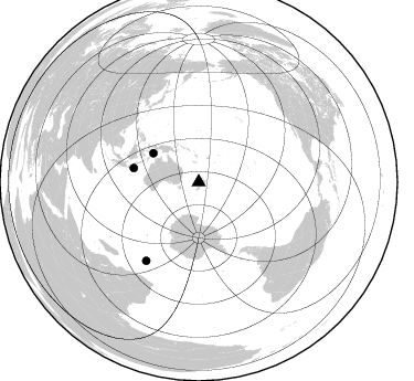
Azimuth Distribution of Events:
Prior Results for this Station
| Study | Thickness | Vp/Vs | Vp | Vs | Poissons Ratio | Extra |
| EARS | 28 km | 1.70 | 6.048 km/s | 3.568 km/s | 0.23 | |
| Crust2.0 | 24 km | 1.81 | 6.048 km/s | 3.34 km/s | 0.28 | S2,continental slope, margin, transition 2 km seds. |
| Global Maxima | 28 km | 1.70 | 6.048 km/s | 3.568 km/s | 0.23 | amp=0.018607415 |
| Local Maxima 1 | 34 km | 1.60 | 6.048 km/s | 3.774 km/s | 0.18 | amp=0.010195936 |
| Local Maxima 2 | 22 km | 1.87 | 6.048 km/s | 3.234 km/s | 0.30 | amp=0.00946475 |
| Local Maxima 3 | 40 km | 1.60 | 6.048 km/s | 3.78 km/s | 0.18 | amp=0.008106521 |
| Local Maxima 4 | 26 km | 1.79 | 6.048 km/s | 3.379 km/s | 0.27 | amp=0.0037238102 |
| Predicted Arrivals for vertical incidence (zero ray parameter) | |
| Ps | 3.19 SECOND |
| PpPs | 12.37 SECOND |
| PsPs/PpSs | 15.55 SECOND |
Events Processed for this Station
Download zip of receiver functions as SAC
Plot maxima for each earthquake.
Events Used in the Stack
(3 events)| Radial Match | Distance | Baz | FERegion | Time | Lat/Lon | Depth | Magnitude |
| 99.77095 | 60.0 deg | 282.102 deg | South Of Java, Indonesia | 2009/09/07 16:12:22 GMT | (-10.2, 110.6) | 23 km | 6.1 MB, 5.9 MS, 6.2 MW, 6.1 MW |
| 99.71382 | 86.0 deg | 213.776 deg | Prince Edward Islands Region | 2009/11/09 00:21:38 GMT | (-43.5, 39.6) | 10 km | 5.5 MB, 5.3 MS, 5.6 MW |
| 82.90509 | 48.7 deg | 302.452 deg | Banda Sea | 2009/10/24 14:40:43 GMT | (-6.1, 130.4) | 130 km | 6.7 MB, 6.9 MW, 6.9 MW |
Losers
(42 events)| Radial Match | Distance | Baz | FERegion | Time | Lat/Lon | Depth | Magnitude | Reason |
| 99.83923 | 73.9 deg | 281.407 deg | Southern Sumatra, Indonesia | 2009/08/23 17:38:23 GMT | (-1.6, 99.6) | 18 km | 5.6 MB, 5.1 MS, 5.4 MW, 5.4 MW | |
| 70.56022 | 53.7 deg | 288.256 deg | South Of Sumbawa, Indonesia | 2009/11/28 06:04:23 GMT | (-10.4, 118.9) | 22 km | 5.9 MB, 5.8 MS, 6.0 MW, 6.0 MW | |
| 69.569595 | 74.3 deg | 282.334 deg | Southern Sumatra, Indonesia | 2009/09/30 10:16:09 GMT | (-0.7, 99.9) | 81 km | 7.1 MB, 7.5 MW, 7.5 MW | |
| 66.13289 | 58.8 deg | 306.514 deg | Talaud Islands, Indonesia | 2009/02/13 21:26:36 GMT | (3.8, 126.5) | 32 km | 5.5 MB, 5.2 MW | |
| 63.495155 | 58.6 deg | 306.53 deg | Talaud Islands, Indonesia | 2009/02/11 17:41:55 GMT | (3.6, 126.6) | 22 km | 5.5 MB | |
| 62.643963 | 46.4 deg | 134.825 deg | Southern East Pacific Rise | 2009/12/03 06:12:32 GMT | (-56.5, -122.3) | 10 km | 5.5 MB, 5.8 MS, 6.0 MW, 6.0 MW | |
| 61.96825 | 97.1 deg | 72.556 deg | Off Coast Of Jalisco, Mexico | 2009/11/23 06:08:39 GMT | (18.1, -105.6) | 35 km | 5.6 MW, 5.1 MS, 5.2 MB, 5.1 MD | |
| 60.931 | 66.5 deg | 281.372 deg | Sunda Strait, Indonesia | 2009/10/16 09:52:50 GMT | (-6.5, 105.2) | 38 km | 5.9 MB, 5.8 MS, 6.1 MW, 6.1 MW | |
| 59.414692 | 54.1 deg | 288.636 deg | Sumbawa Region, Indonesia | 2009/10/24 20:54:50 GMT | (-9.9, 118.8) | 35 km | 5.5 MB, 5.2 MS, 5.6 MW | |
| 58.510693 | 66.4 deg | 117.894 deg | Southeast Of Easter Island | 2009/07/08 19:23:37 GMT | (-36.0, -102.7) | 12 km | 5.5 MS, 5.4 MB, 6.0 MW, 5.9 MW | |
| 56.987457 | 89.1 deg | 85.064 deg | Galapagos Triple Junction Region | 2009/10/15 17:48:21 GMT | (3.3, -103.8) | 10 km | 5.9 MB, 5.7 MS, 6.0 MW, 6.0 MW | |
| 55.95091 | 69.1 deg | 281.124 deg | Southern Sumatra, Indonesia | 2009/06/20 09:21:23 GMT | (-5.0, 103.0) | 46 km | 5.8 MB, 5.4 MW, 5.4 MW | |
| 55.824234 | 47.4 deg | 300.631 deg | Tanimbar Islands Reg., Indonesia | 2009/04/03 13:37:58 GMT | (-8.0, 130.2) | 35 km | 5.6 MW, 5.2 MS, 5.1 MB, 5.6 MW | |
| 55.653965 | 94.7 deg | 132.097 deg | Catamarca Province, Argentina | 2009/08/12 18:00:52 GMT | (-27.9, -66.7) | 174 km | 5.5 MW, 5.3 MB, 5.5 MW | |
| 55.505062 | 77.9 deg | 321.421 deg | Northwest Of Ryukyu Islands | 2009/03/26 19:19:59 GMT | (27.4, 126.7) | 160 km | 5.6 MB, 5.9 MW, 5.9 MW | |
| 55.369434 | 75.1 deg | 321.049 deg | Southeast Of Ryukyu Islands | 2009/07/06 22:35:05 GMT | (24.9, 128.0) | 10 km | 6.1 MB, 5.3 MS, 5.7 MW, 5.7 MW | |
| 54.779648 | 46.8 deg | 315.293 deg | Near North Coast Of Irian Jaya | 2009/03/10 17:42:14 GMT | (-1.9, 139.1) | 18 km | 5.5 MB, 5.2 MS, 5.5 MW, 5.4 MW | |
| 54.43348 | 89.0 deg | 350.076 deg | Kuril Islands | 2009/04/14 03:04:27 GMT | (48.8, 154.9) | 44 km | 5.5 MW | |
| 53.383144 | 63.2 deg | 106.741 deg | Easter Island Region | 2009/09/17 23:21:38 GMT | (-29.1, -112.3) | 10 km | 5.7 MB, 6.0 MS, 6.2 MW, 6.2 MW | |
| 52.483097 | 62.0 deg | 306.897 deg | Mindanao, Philippines | 2009/09/18 11:53:48 GMT | (6.5, 124.7) | 10 km | 5.7 MW, 5.7 MW | |
| 51.91775 | 69.4 deg | 279.55 deg | Southwest Of Sumatra, Indonesia | 2009/04/01 06:29:40 GMT | (-6.0, 101.9) | 35 km | 5.6 MW, 5.2 MS, 5.3 MB | |
| 51.235573 | 77.4 deg | 316.092 deg | Taiwan Region | 2009/07/16 10:48:16 GMT | (24.1, 122.2) | 44 km | 5.5 MB | |
| 51.10606 | 58.5 deg | 306.603 deg | Talaud Islands, Indonesia | 2009/03/16 17:42:03 GMT | (3.6, 126.7) | 18 km | 5.7 MW, 5.6 MW | |
| 50.63635 | 93.9 deg | 13.75 deg | Fox Islands, Aleutian Islands | 2009/10/13 20:21:53 GMT | (52.6, -167.1) | 14 km | 5.9 MB, 6.4 MS, 6.4 MW, 6.4 MW | |
| 50.064793 | 95.4 deg | 69.259 deg | Revilla Gigedo Islands Region | 2009/06/03 21:37:37 GMT | (19.6, -109.2) | 6.0 km | 5.6 MW, 5.1 MS, 5.2 MB, 5.5 MW | |
| 49.74491 | 85.9 deg | 209.791 deg | Prince Edward Islands Region | 2009/06/04 17:25:25 GMT | (-45.8, 35.1) | 16 km | 5.5 MB, 5.7 MS, 6.0 MW, 6.0 MW | |
| 49.225346 | 92.0 deg | 294.843 deg | Myanmar | 2009/09/21 19:38:42 GMT | (20.4, 94.8) | 84 km | 5.6 MB, 5.7 MW, 5.6 MW | |
| 49.074745 | 96.1 deg | 70.835 deg | Off Coast Of Jalisco, Mexico | 2009/10/06 17:22:50 GMT | (18.8, -107.5) | 10 km | 5.5 MW, 4.9 MS, 5.2 MB, 5.4 MW | |
| 49.03307 | 88.5 deg | 349.54 deg | Kuril Islands | 2009/09/11 08:49:11 GMT | (48.3, 154.2) | 35 km | 5.8 MB, 5.0 MS, 5.6 MW, 5.6 MW | |
| 46.9449 | 91.2 deg | 7.304 deg | Andreanof Islands, Aleutian Is. | 2009/03/30 12:07:28 GMT | (51.5, -178.3) | 31 km | 6.0 MB, 5.5 MS, 5.7 MW, 5.7 MW | |
| 46.812958 | 51.8 deg | 296.81 deg | Banda Sea | 2009/04/13 13:36:46 GMT | (-6.8, 125.1) | 554 km | 5.6 MW | |
| 45.946545 | 84.5 deg | 340.385 deg | Hokkaido, Japan Region | 2009/06/05 03:30:33 GMT | (41.8, 143.4) | 29 km | 6.0 MB, 6.3 MS, 6.4 MW, 6.4 MW | |
| 45.5585 | 77.7 deg | 282.198 deg | Northern Sumatra, Indonesia | 2009/02/24 12:13:15 GMT | (1.4, 97.2) | 35 km | 5.6 MB, 5.7 MS, 5.7 MW, 5.5 MW | |
| 42.362453 | 91.6 deg | 4.952 deg | Rat Islands, Aleutian Islands | 2009/10/07 05:38:37 GMT | (52.2, 178.1) | 138 km | 5.6 MB, 5.6 MW, 5.6 MW | |
| 41.835396 | 66.0 deg | 311.442 deg | Samar, Philippines | 2009/12/02 20:27:12 GMT | (12.2, 125.6) | 14 km | 5.5 MW | |
| 40.654118 | 59.5 deg | 238.996 deg | Southeast Indian Ridge | 2009/02/25 16:08:00 GMT | (-41.9, 88.6) | 10 km | 5.5 MW, 5.5 MB, 5.5 MW | |
| 39.86935 | 71.9 deg | 282.04 deg | Southern Sumatra, Indonesia | 2009/10/01 01:52:27 GMT | (-2.5, 101.5) | 9.7 km | 5.9 MB, 6.7 MS, 6.6 MW, 6.6 MW | |
| 39.839336 | 37.6 deg | 330.864 deg | New Britain Region, P.N.G. | 2009/07/29 21:33:05 GMT | (-5.1, 152.6) | 43 km | 5.5 MW | |
| 39.672123 | 55.4 deg | 297.813 deg | Sulawesi, Indonesia | 2009/10/15 18:33:36 GMT | (-3.6, 123.2) | 17 km | 6.0 MB, 5.3 MS, 5.7 MW, 5.7 MW | |
| 37.840313 | 89.8 deg | 132.865 deg | Mendoza Province, Argentina | 2009/05/08 13:44:53 GMT | (-32.1, -69.7) | 112 km | 5.6 MB, 5.4 MW | |
| 34.26068 | 96.6 deg | 71.762 deg | Off Coast Of Jalisco, Mexico | 2009/05/29 01:04:38 GMT | (18.4, -106.5) | 11 km | 5.5 MW, 5.0 MS, 5.0 MB, 5.3 MW | |
| 29.731936 | 89.8 deg | 4.465 deg | Rat Islands, Aleutian Islands | 2009/07/06 14:53:12 GMT | (50.4, 177.0) | 22 km | 6.0 MB, 5.8 MS, 6.1 MW, 6.0 MW |
