
Station ZV WKZ05 - SAND_CRITTER
Network: ZV16 - Seismic Noise Survey of Western Kazakhstan
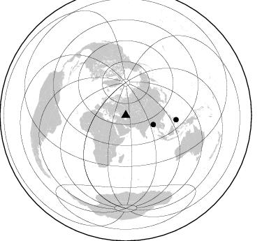
Nearby stations (2 deg radius)
| Station | Name | (Lat, Lon) | Start / End | Elevation |
| WKZ05 | SAND_CRITTER | (43.34, 52.30) | 2016-08-18 / 2016-09-12 | 127 m |
| Crust2 Type: | D7,Platform 4 km seds. |
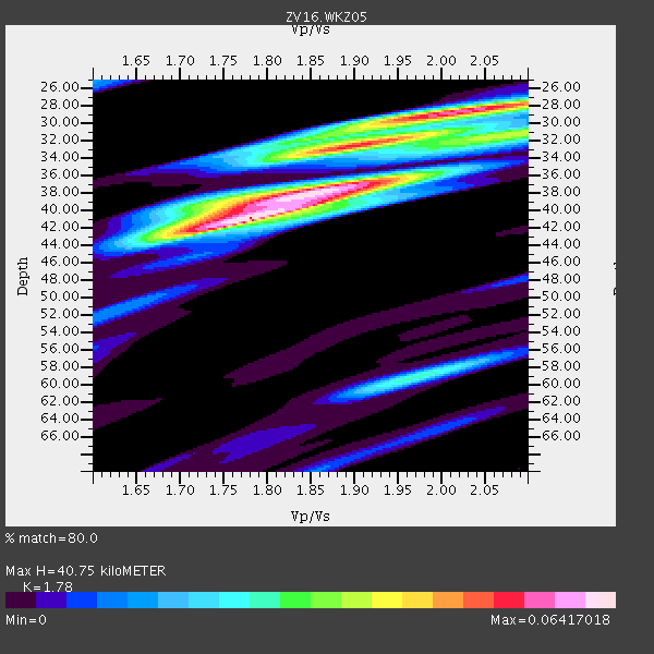
| Thickness Estimate: | 41 km |
| Thickness StdDev: | 3.3 km |
| Vp/Vs Estimate: | 1.78 |
| Vp/Vs StdDev: | 0.05 |
| Vs Estimate: | 3.559 km/s |
| Poisson's Ratio: | 0.27 |
| Peak Value: | 0.06 |
| Assumed Vp: | 6.334 km/s |
| Ps Weight: | 0.33333334 |
| PpPs Weight: | 0.33333334 |
| PsPs Weight: | 0.33333328 |
| Residual Complexity: | 0.778 |
| Nearby stations H: | +- |
| (2.0 deg) Vp/Vs: | +- |
1 with match > 90% ( 8.333333 %) and 2 with match > 80% ( 16.666666 %) out of 12.
Download stack as xyz text file.
Azimuth Distribution of Events:
Prior Results for this Station
| Study | Thickness | Vp/Vs | Vp | Vs | Poissons Ratio | Extra |
| EARS | 41 km | 1.78 | 6.334 km/s | 3.559 km/s | 0.27 | |
| Crust2.0 | 41 km | 1.78 | 6.334 km/s | 3.561 km/s | 0.27 | D7,Platform 4 km seds. |
| Global Maxima | 41 km | 1.78 | 6.334 km/s | 3.559 km/s | 0.27 | amp=0.06417018 |
| Local Maxima 1 | 29 km | 2.01 | 6.334 km/s | 3.159 km/s | 0.33 | amp=0.055774186 |
| Local Maxima 2 | 38 km | 1.88 | 6.334 km/s | 3.378 km/s | 0.30 | amp=0.055568792 |
| Local Maxima 3 | 33 km | 1.88 | 6.334 km/s | 3.369 km/s | 0.30 | amp=0.038234673 |
| Local Maxima 4 | 59 km | 1.97 | 6.334 km/s | 3.215 km/s | 0.33 | amp=0.026764609 |
| Predicted Arrivals for vertical incidence (zero ray parameter) | |
| Ps | 5.02 SECOND |
| PpPs | 17.88 SECOND |
| PsPs/PpSs | 22.90 SECOND |
Events Processed for this Station
Download zip of receiver functions as SAC
Plot maxima for each earthquake.
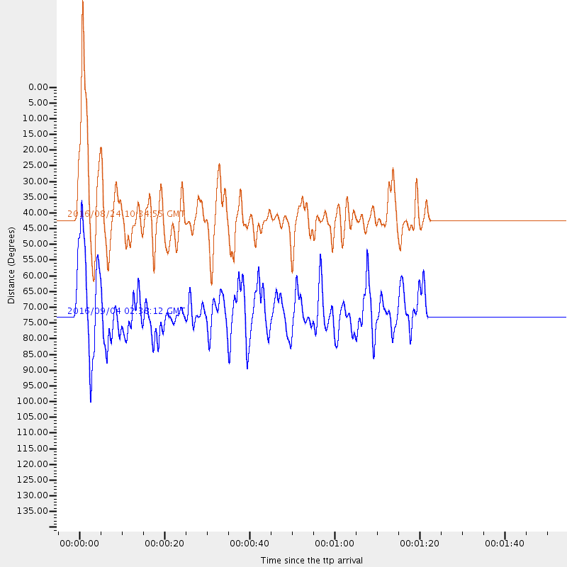
Events Used in the Stack
(2 events)| Radial Match | Distance | Baz | FERegion | Time | Lat/Lon | Depth | Magnitude |
| 93.886444 | 41.6 deg | 108.79 deg | Myanmar | 2016/08/24 10:34:55 GMT | (20.9, 94.6) | 84 km | 6.8 MO |
| 83.313614 | 72.4 deg | 95.128 deg | Mindanao, Philippines | 2016/09/04 02:38:12 GMT | (8.4, 125.9) | 12 km | 5.9 MWP |
Losers
(10 events)| Radial Match | Distance | Baz | FERegion | Time | Lat/Lon | Depth | Magnitude | Reason |
| 93.25575 | 75.7 deg | 256.081 deg | North Of Ascension Island | 2016/08/29 04:29:57 GMT | (-0.0, -17.8) | 10 km | 7.1 MWW, 7.1 MWC, 7.4 MI | |
| 90.78125 | 64.7 deg | 57.685 deg | Off East Coast Of Honshu, Japan | 2016/08/20 09:01:26 GMT | (40.4, 143.7) | 10 km | 6.0 MO | |
| 86.35686 | 64.8 deg | 57.704 deg | Off East Coast Of Honshu, Japan | 2016/08/20 15:58:04 GMT | (40.3, 143.8) | 10 km | 6.0 MO | |
| 78.25828 | 62.9 deg | 123.883 deg | Southern Sumatra, Indonesia | 2016/08/24 13:48:44 GMT | (-3.0, 100.1) | 17 km | 5.8 MB | |
| 76.77069 | 80.8 deg | 109.049 deg | Flores Sea | 2016/08/23 19:39:44 GMT | (-7.3, 122.5) | 528 km | 6.0 MB | |
| 73.60787 | 68.6 deg | 34.319 deg | Komandorskiye Ostrova Region | 2016/09/05 22:54:04 GMT | (54.3, 168.6) | 10 km | 5.7 MB | |
| 63.82483 | 89.1 deg | 94.668 deg | Irian Jaya, Indonesia | 2016/08/28 07:23:50 GMT | (-2.8, 138.4) | 28 km | 5.7 MB | |
| 54.159206 | 80.8 deg | 108.932 deg | Flores Sea | 2016/08/23 19:40:46 GMT | (-7.2, 122.5) | 514 km | 5.8 MB | |
| 51.698174 | 66.7 deg | 69.346 deg | Southeast Of Honshu, Japan | 2016/08/25 17:04:43 GMT | (30.6, 137.8) | 456 km | 5.9 MWW, 5.9 MWB | |
| 49.66985 | 68.0 deg | 69.218 deg | Southeast Of Honshu, Japan | 2016/08/22 09:33:08 GMT | (29.9, 139.1) | 404 km | 5.6 MB |

