You are here: Home > Network List > TX - Texas Seismological Network Stations List
> Station MB15 UL Block 19, Section 6 > Earthquake Result Viewer
MB15 UL Block 19, Section 6 - Earthquake Result Viewer
| Earthquake location: |
Tonga Islands |
| Earthquake latitude/longitude: |
-19.4/-174.9 |
| Earthquake time(UTC): |
2024/05/26 (147) 20:47:09 GMT |
| Earthquake Depth: |
112 km |
| Earthquake Magnitude: |
6.6 mww |
| Earthquake Catalog/Contributor: |
NEIC PDE/us |
|
| Network: |
TX Texas Seismological Network |
| Station: |
MB15 UL Block 19, Section 6 |
| Lat/Lon: |
32.39 N/102.17 W |
| Elevation: |
999 m |
|
| Distance: |
86.5 deg |
| Az: |
54.026 deg |
| Baz: |
244.565 deg |
| Ray Param: |
0.04379159 |
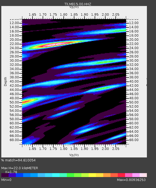
| Estimated Moho Depth: |
22.0 km |
| Estimated Crust Vp/Vs: |
1.76 |
| Assumed Crust Vp: |
6.129 km/s |
| Estimated Crust Vs: |
3.482 km/s |
| Estimated Crust Poisson's Ratio: |
0.26 |
|
| Radial Match: |
94.610054 % |
| Radial Bump: |
341 |
| Transverse Match: |
86.096405 % |
| Transverse Bump: |
400 |
| SOD ConfigId: |
35001331 |
| Insert Time: |
2024-06-09 21:21:27.362 +0000 |
| GWidth: |
2.5 |
| Max Bumps: |
400 |
| Tol: |
0.001 |
|

Signal To Noise
| Channel | StoN | STA | LTA |
| TX:MB15:00:HHZ:20240526T20:59:08.209989Z | 6.973445 | 4.61564E-6 | 6.618881E-7 |
| TX:MB15:00:HH1:20240526T20:59:08.209989Z | 2.0499153 | 5.0048294E-7 | 2.441481E-7 |
| TX:MB15:00:HH2:20240526T20:59:08.209989Z | 8.257965 | 1.1581724E-6 | 1.4024913E-7 |
| Arrivals |
| Ps | 2.8 SECOND |
| PpPs | 9.7 SECOND |
| PsPs/PpSs | 12 SECOND |


