You are here: Home > Network List > TX - Texas Seismological Network Stations List
> Station MB15 UL Block 19, Section 6 > Earthquake Result Viewer
MB15 UL Block 19, Section 6 - Earthquake Result Viewer
| Earthquake location: |
Northern Mid-Atlantic Ridge |
| Earthquake latitude/longitude: |
29.6/-42.8 |
| Earthquake time(UTC): |
2024/06/03 (155) 06:41:51 GMT |
| Earthquake Depth: |
10 km |
| Earthquake Magnitude: |
5.9 mww |
| Earthquake Catalog/Contributor: |
NEIC PDE/us |
|
| Network: |
TX Texas Seismological Network |
| Station: |
MB15 UL Block 19, Section 6 |
| Lat/Lon: |
32.39 N/102.17 W |
| Elevation: |
999 m |
|
| Distance: |
50.4 deg |
| Az: |
289.097 deg |
| Baz: |
76.519 deg |
| Ray Param: |
0.06810403 |
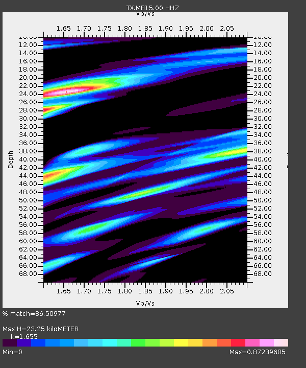
| Estimated Moho Depth: |
23.25 km |
| Estimated Crust Vp/Vs: |
1.65 |
| Assumed Crust Vp: |
6.129 km/s |
| Estimated Crust Vs: |
3.703 km/s |
| Estimated Crust Poisson's Ratio: |
0.21 |
|
| Radial Match: |
86.50977 % |
| Radial Bump: |
400 |
| Transverse Match: |
61.85561 % |
| Transverse Bump: |
400 |
| SOD ConfigId: |
35001331 |
| Insert Time: |
2024-06-17 07:15:24.230 +0000 |
| GWidth: |
2.5 |
| Max Bumps: |
400 |
| Tol: |
0.001 |
|

Signal To Noise
| Channel | StoN | STA | LTA |
| TX:MB15:00:HHZ:20240603T06:50:17.649993Z | 9.057709 | 9.160759E-7 | 1.0113771E-7 |
| TX:MB15:00:HH1:20240603T06:50:17.649993Z | 1.9430273 | 2.0208024E-7 | 1.0400278E-7 |
| TX:MB15:00:HH2:20240603T06:50:17.649993Z | 6.557799 | 5.156443E-7 | 7.86307E-8 |
| Arrivals |
| Ps | 2.6 SECOND |
| PpPs | 9.5 SECOND |
| PsPs/PpSs | 12 SECOND |


