You are here: Home > Network List > XJ97 - Sierran Paradox Stations List
> Station BRR Blackrock Reservior > Earthquake Result Viewer
BRR Blackrock Reservior - Earthquake Result Viewer
| Earthquake location: |
Kuril Islands |
| Earthquake latitude/longitude: |
43.2/146.4 |
| Earthquake time(UTC): |
1997/07/14 (195) 16:09:35 GMT |
| Earthquake Depth: |
33 km |
| Earthquake Magnitude: |
5.9 MB, 5.8 MS, 6.1 UNKNOWN, 5.8 ME |
| Earthquake Catalog/Contributor: |
WHDF/NEIC |
|
| Network: |
XJ Sierran Paradox |
| Station: |
BRR Blackrock Reservior |
| Lat/Lon: |
36.91 N/119.04 W |
| Elevation: |
1259 m |
|
| Distance: |
68.8 deg |
| Az: |
58.968 deg |
| Baz: |
308.631 deg |
| Ray Param: |
0.056012724 |
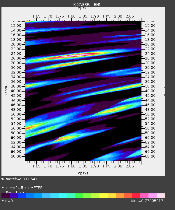
| Estimated Moho Depth: |
24.5 km |
| Estimated Crust Vp/Vs: |
1.82 |
| Assumed Crust Vp: |
6.291 km/s |
| Estimated Crust Vs: |
3.461 km/s |
| Estimated Crust Poisson's Ratio: |
0.28 |
|
| Radial Match: |
90.00541 % |
| Radial Bump: |
400 |
| Transverse Match: |
75.981674 % |
| Transverse Bump: |
400 |
| SOD ConfigId: |
6273 |
| Insert Time: |
2010-03-09 20:08:07.663 +0000 |
| GWidth: |
2.5 |
| Max Bumps: |
400 |
| Tol: |
0.001 |
|

Signal To Noise
| Channel | StoN | STA | LTA |
| XJ:BRR: :BHN:19970714T16:20:05.552002Z | 1.7499225 | 1.0417386E-7 | 5.9530553E-8 |
| XJ:BRR: :BHE:19970714T16:20:05.552002Z | 3.7951174 | 1.4705483E-7 | 3.8748432E-8 |
| XJ:BRR: :BHZ:19970714T16:20:05.552002Z | 6.6252203 | 4.997909E-7 | 7.5437626E-8 |
| Arrivals |
| Ps | 3.3 SECOND |
| PpPs | 11 SECOND |
| PsPs/PpSs | 14 SECOND |


