You are here: Home > Network List > XJ97 - Sierran Paradox Stations List
> Station BRR Blackrock Reservior > Earthquake Result Viewer
BRR Blackrock Reservior - Earthquake Result Viewer
| Earthquake location: |
Tonga Islands |
| Earthquake latitude/longitude: |
-21.3/-174.4 |
| Earthquake time(UTC): |
1997/09/10 (253) 12:57:07 GMT |
| Earthquake Depth: |
10 km |
| Earthquake Magnitude: |
5.7 MB, 6.1 MS, 6.1 UNKNOWN, 5.9 MW |
| Earthquake Catalog/Contributor: |
WHDF/NEIC |
|
| Network: |
XJ Sierran Paradox |
| Station: |
BRR Blackrock Reservior |
| Lat/Lon: |
36.91 N/119.04 W |
| Elevation: |
1259 m |
|
| Distance: |
78.0 deg |
| Az: |
42.384 deg |
| Baz: |
231.633 deg |
| Ray Param: |
0.049959216 |
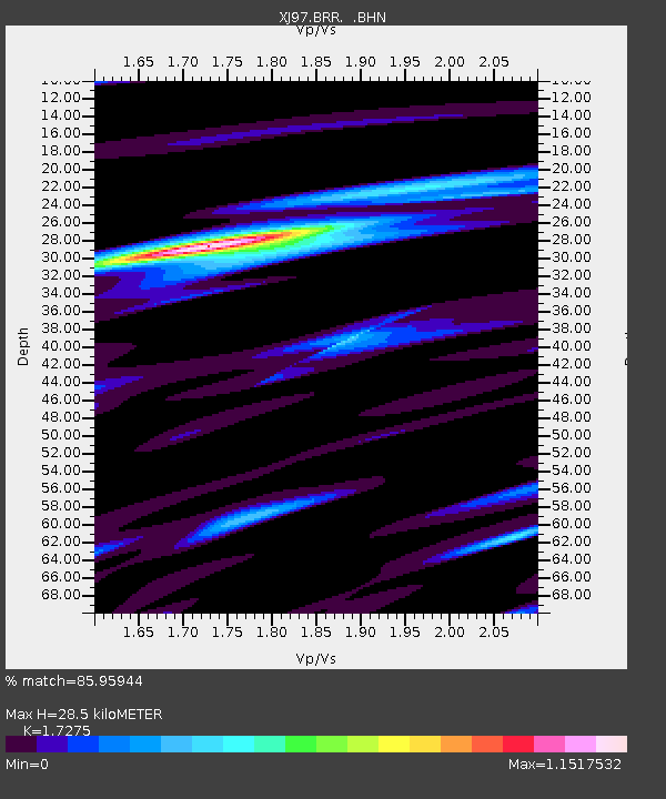
| Estimated Moho Depth: |
28.5 km |
| Estimated Crust Vp/Vs: |
1.73 |
| Assumed Crust Vp: |
6.291 km/s |
| Estimated Crust Vs: |
3.642 km/s |
| Estimated Crust Poisson's Ratio: |
0.25 |
|
| Radial Match: |
85.95944 % |
| Radial Bump: |
312 |
| Transverse Match: |
62.990383 % |
| Transverse Bump: |
400 |
| SOD ConfigId: |
6273 |
| Insert Time: |
2010-03-09 20:08:14.761 +0000 |
| GWidth: |
2.5 |
| Max Bumps: |
400 |
| Tol: |
0.001 |
|

Signal To Noise
| Channel | StoN | STA | LTA |
| XJ:BRR: :BHN:19970910T13:08:33.952026Z | 1.5820065 | 1.967539E-7 | 1.2436985E-7 |
| XJ:BRR: :BHE:19970910T13:08:33.952026Z | 1.802549 | 1.5299884E-7 | 8.4879154E-8 |
| XJ:BRR: :BHZ:19970910T13:08:33.952026Z | 4.281162 | 4.026971E-7 | 9.406258E-8 |
| Arrivals |
| Ps | 3.4 SECOND |
| PpPs | 12 SECOND |
| PsPs/PpSs | 15 SECOND |


