You are here: Home > Network List > XJ97 - Sierran Paradox Stations List
> Station BRR Blackrock Reservior > Earthquake Result Viewer
BRR Blackrock Reservior - Earthquake Result Viewer
| Earthquake location: |
Kermadec Islands Region |
| Earthquake latitude/longitude: |
-28.7/-177.6 |
| Earthquake time(UTC): |
1997/09/20 (263) 16:11:32 GMT |
| Earthquake Depth: |
30 km |
| Earthquake Magnitude: |
6.1 MB, 7.0 MS, 7.2 UNKNOWN, 6.7 ME |
| Earthquake Catalog/Contributor: |
WHDF/NEIC |
|
| Network: |
XJ Sierran Paradox |
| Station: |
BRR Blackrock Reservior |
| Lat/Lon: |
36.91 N/119.04 W |
| Elevation: |
1259 m |
|
| Distance: |
85.3 deg |
| Az: |
43.336 deg |
| Baz: |
228.794 deg |
| Ray Param: |
0.044808898 |
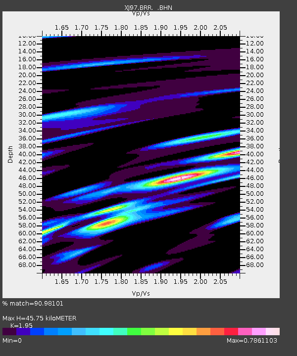
| Estimated Moho Depth: |
45.75 km |
| Estimated Crust Vp/Vs: |
1.95 |
| Assumed Crust Vp: |
6.291 km/s |
| Estimated Crust Vs: |
3.226 km/s |
| Estimated Crust Poisson's Ratio: |
0.32 |
|
| Radial Match: |
90.98101 % |
| Radial Bump: |
400 |
| Transverse Match: |
75.892746 % |
| Transverse Bump: |
400 |
| SOD ConfigId: |
6273 |
| Insert Time: |
2010-03-09 20:08:16.205 +0000 |
| GWidth: |
2.5 |
| Max Bumps: |
400 |
| Tol: |
0.001 |
|

Signal To Noise
| Channel | StoN | STA | LTA |
| XJ:BRR: :BHN:19970920T16:23:34.943018Z | 4.4815135 | 6.278668E-7 | 1.4010152E-7 |
| XJ:BRR: :BHE:19970920T16:23:34.943018Z | 3.999343 | 8.21301E-7 | 2.0535899E-7 |
| XJ:BRR: :BHZ:19970920T16:23:34.943018Z | 14.517671 | 2.2960721E-6 | 1.5815706E-7 |
| Arrivals |
| Ps | 7.1 SECOND |
| PpPs | 21 SECOND |
| PsPs/PpSs | 28 SECOND |


