You are here: Home > Network List > TX - Texas Seismological Network Stations List
> Station MB08 UTPB > Earthquake Result Viewer
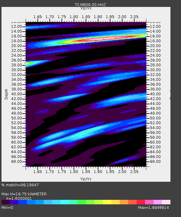
MB08 UTPB - Earthquake Result Viewer
| Earthquake location: |
Tonga Islands |
| Earthquake latitude/longitude: |
-18.7/-175.5 |
| Earthquake time(UTC): |
2023/12/11 (345) 06:33:31 GMT |
| Earthquake Depth: |
238 km |
| Earthquake Magnitude: |
6.1 Mww |
| Earthquake Catalog/Contributor: |
NEIC PDE/us |
|
| Network: |
TX Texas Seismological Network |
| Station: |
MB08 UTPB |
| Lat/Lon: |
31.88 N/102.33 W |
| Elevation: |
863 m |
|
| Distance: |
86.2 deg |
| Az: |
54.686 deg |
| Baz: |
245.411 deg |
| Ray Param: |
0.043654416 |
| Estimated Moho Depth: |
16.75 km |
| Estimated Crust Vp/Vs: |
1.92 |
| Assumed Crust Vp: |
6.121 km/s |
| Estimated Crust Vs: |
3.188 km/s |
| Estimated Crust Poisson's Ratio: |
0.31 |
|
| Radial Match: |
86.19847 % |
| Radial Bump: |
400 |
| Transverse Match: |
69.26917 % |
| Transverse Bump: |
399 |
| SOD ConfigId: |
34243671 |
| Insert Time: |
2024-05-07 13:15:03.047 +0000 |
| GWidth: |
2.5 |
| Max Bumps: |
400 |
| Tol: |
0.001 |
|

Signal To Noise
| Channel | StoN | STA | LTA |
| TX:MB08:00:HHZ:20231211T06:45:14.149995Z | 6.752194 | 1.5090758E-6 | 2.2349414E-7 |
| TX:MB08:00:HH1:20231211T06:45:14.149995Z | 1.4494859 | 2.6294748E-7 | 1.814074E-7 |
| TX:MB08:00:HH2:20231211T06:45:14.149995Z | 2.3586488 | 4.4348974E-7 | 1.8802703E-7 |
| Arrivals |
| Ps | 2.6 SECOND |
| PpPs | 7.8 SECOND |
| PsPs/PpSs | 10 SECOND |


