You are here: Home > Network List > TA - USArray Transportable Network (new EarthScope stations) Stations List
> Station K06A Valley Falls, OR, USA > Earthquake Result Viewer
K06A Valley Falls, OR, USA - Earthquake Result Viewer
| Earthquake location: |
Near Coast Of Peru |
| Earthquake latitude/longitude: |
-13.6/-76.6 |
| Earthquake time(UTC): |
2007/08/19 (231) 01:22:40 GMT |
| Earthquake Depth: |
26 km |
| Earthquake Magnitude: |
5.9 MB, 5.4 MS, 5.8 MW, 5.5 ML |
| Earthquake Catalog/Contributor: |
WHDF/NEIC |
|
| Network: |
TA USArray Transportable Network (new EarthScope stations) |
| Station: |
K06A Valley Falls, OR, USA |
| Lat/Lon: |
42.80 N/120.25 W |
| Elevation: |
1340 m |
|
| Distance: |
68.9 deg |
| Az: |
327.026 deg |
| Baz: |
134.035 deg |
| Ray Param: |
0.05594272 |
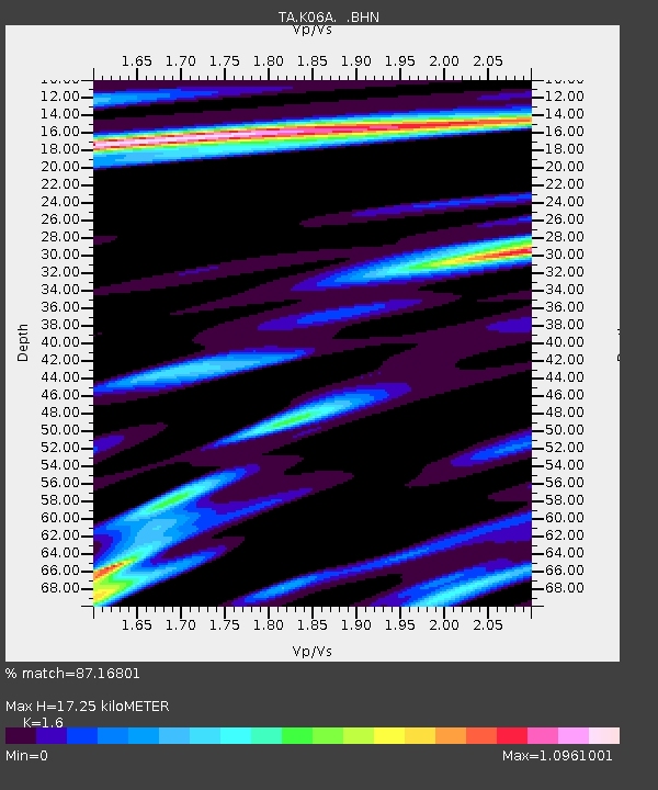
| Estimated Moho Depth: |
17.25 km |
| Estimated Crust Vp/Vs: |
1.60 |
| Assumed Crust Vp: |
6.597 km/s |
| Estimated Crust Vs: |
4.123 km/s |
| Estimated Crust Poisson's Ratio: |
0.18 |
|
| Radial Match: |
87.16801 % |
| Radial Bump: |
400 |
| Transverse Match: |
79.613525 % |
| Transverse Bump: |
400 |
| SOD ConfigId: |
2564 |
| Insert Time: |
2010-03-07 03:15:27.682 +0000 |
| GWidth: |
2.5 |
| Max Bumps: |
400 |
| Tol: |
0.001 |
|

Signal To Noise
| Channel | StoN | STA | LTA |
| TA:K06A: :BHN:20070819T01:33:12.225002Z | 0.87945515 | 8.8871715E-8 | 1.0105315E-7 |
| TA:K06A: :BHE:20070819T01:33:12.225002Z | 1.7574428 | 1.255046E-7 | 7.141318E-8 |
| TA:K06A: :BHZ:20070819T01:33:12.225002Z | 7.157002 | 5.8097595E-7 | 8.1175884E-8 |
| Arrivals |
| Ps | 1.6 SECOND |
| PpPs | 6.5 SECOND |
| PsPs/PpSs | 8.1 SECOND |


