
Station TA K06A - Valley Falls, OR, USA
Network: TA - USArray Transportable Network (new EarthScope stations)
Nearby stations (2 deg radius)
| Station | Name | (Lat, Lon) | Start / End | Elevation |
| K06A | Valley Falls, OR, USA | (42.80, -120.25) | 2006-01-29 / 2499-01-01 | 1.3 km |
| Crust2 Type: | L3,continental arc, Southern Andes, 0.2 km seds. |
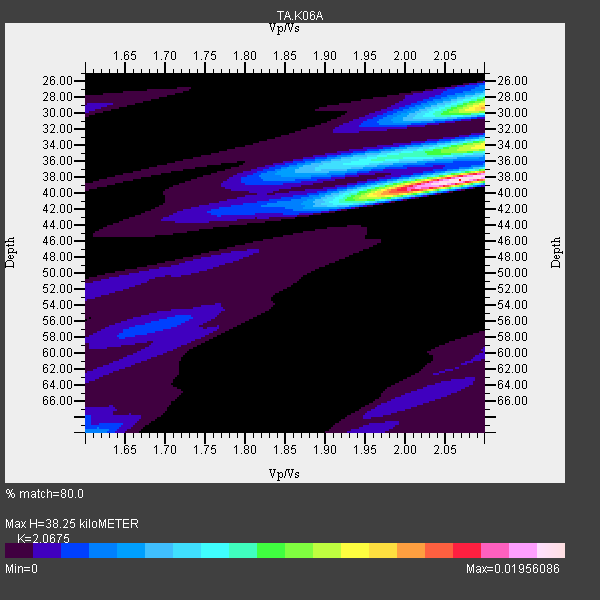
| Thickness Estimate: | 38 km |
| Thickness StdDev: | 2.6 km |
| Vp/Vs Estimate: | 2.07 |
| Vp/Vs StdDev: | 0.02 |
| Vs Estimate: | 3.191 km/s |
| Poisson's Ratio: | 0.35 |
| Peak Value: | 0.02 |
| Assumed Vp: | 6.597 km/s |
| Ps Weight: | 0.33333334 |
| PpPs Weight: | 0.33333334 |
| PsPs Weight: | 0.33333328 |
| Residual Complexity: | 0.637 |
| Nearby stations H: | +- |
| (2.0 deg) Vp/Vs: | +- |
17 with match > 90% ( 36.95652 %) and 46 with match > 80% ( 100.0 %) out of 46.
Download stack as xyz text file.
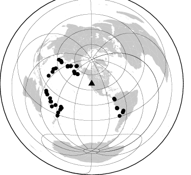
Azimuth Distribution of Events:
Prior Results for this Station
| Study | Thickness | Vp/Vs | Vp | Vs | Poissons Ratio | Extra |
| EARS | 38 km | 2.07 | 6.597 km/s | 3.191 km/s | 0.35 | |
| Crust2.0 | 40 km | 1.77 | 6.597 km/s | 3.723 km/s | 0.27 | L3,continental arc, Southern Andes, 0.2 km seds. |
| Global Maxima | 38 km | 2.07 | 6.597 km/s | 3.191 km/s | 0.35 | amp=0.01956086 |
| Local Maxima 1 | 29 km | 2.10 | 6.597 km/s | 3.145 km/s | 0.35 | amp=0.014041269 |
| Local Maxima 2 | 34 km | 2.10 | 6.597 km/s | 3.145 km/s | 0.35 | amp=0.011508375 |
| Local Maxima 3 | 28 km | 2.10 | 6.597 km/s | 3.145 km/s | 0.35 | amp=0.0055826223 |
| Local Maxima 4 | 70 km | 1.62 | 6.597 km/s | 4.079 km/s | 0.19 | amp=0.0031889644 |
| Predicted Arrivals for vertical incidence (zero ray parameter) | |
| Ps | 6.19 SECOND |
| PpPs | 17.78 SECOND |
| PsPs/PpSs | 23.97 SECOND |
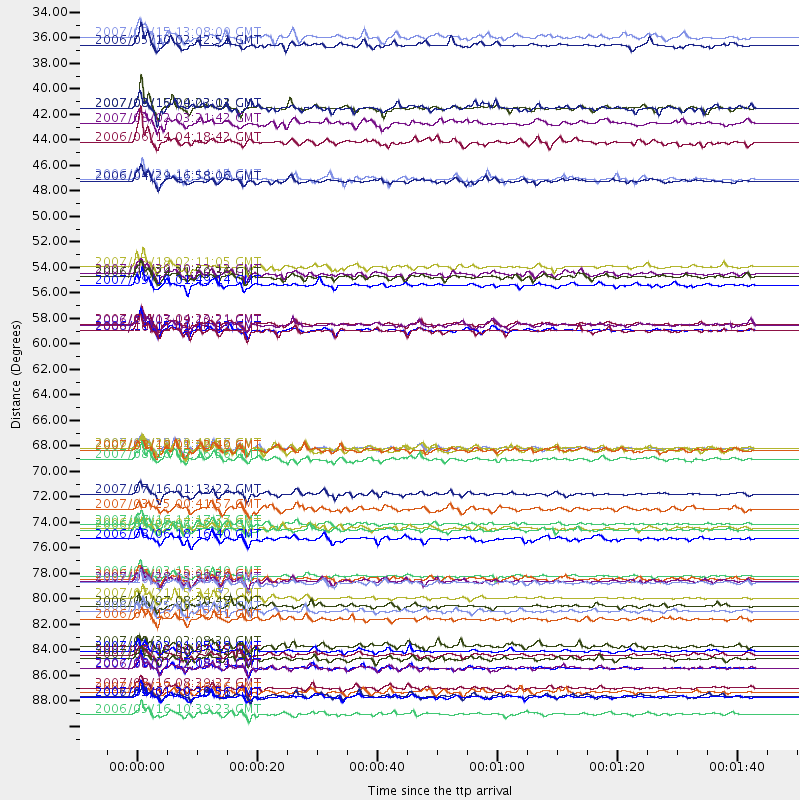
Events Processed for this Station
Download zip of receiver functions as SAC
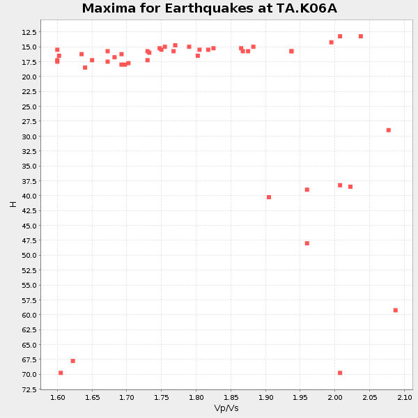
Plot maxima for each earthquake.
Events Used in the Stack
(46 events)| Radial Match | Distance | Baz | FERegion | Time | Lat/Lon | Depth | Magnitude |
| 98.94874 | 58.6 deg | 306.232 deg | Kuril Islands | 2006/11/15 11:14:13 GMT | (46.6, 153.3) | 10 km | 6.5 MB, 7.8 MS, 8.3 MW, 7.9 MW |
| 98.1262 | 68.7 deg | 133.883 deg | Near Coast Of Peru | 2007/08/15 23:40:57 GMT | (-13.4, -76.6) | 39 km | 6.7 MB, 7.9 MS, 8.0 MW, 7.5 ME |
| 97.35156 | 86.4 deg | 250.682 deg | Santa Cruz Islands | 2007/09/02 01:05:18 GMT | (-11.6, 165.8) | 35 km | 5.9 MB, 7.3 MS, 7.2 MW, 6.9 ME |
| 97.088806 | 90.4 deg | 258.895 deg | Solomon Islands | 2007/04/01 20:39:56 GMT | (-8.5, 157.0) | 10 km | 6.8 MB, 7.9 MS, 8.1 MW, 7.7 ME |
| 97.06233 | 79.9 deg | 230.411 deg | Tonga Islands | 2006/05/03 15:26:40 GMT | (-20.2, -174.1) | 55 km | 7.2 MB, 7.8 MS, 7.9 MW, 7.9 MW |
| 96.11753 | 87.9 deg | 246.562 deg | Vanuatu Islands | 2007/08/01 17:08:51 GMT | (-15.6, 167.7) | 120 km | 6.2 MB, 7.2 MW, 7.2 MW |
| 95.27362 | 58.0 deg | 305.36 deg | East Of Kuril Islands | 2007/01/13 04:23:21 GMT | (46.2, 154.5) | 10 km | 7.3 MB, 8.2 MS, 8.1 MW, 7.9 MW |
| 94.93101 | 81.8 deg | 130.332 deg | Jujuy Province, Argentina | 2007/07/21 15:34:52 GMT | (-22.2, -65.8) | 290 km | 5.8 MB, 6.4 MW, 6.3 MW |
| 94.49985 | 89.6 deg | 256.263 deg | Solomon Islands | 2007/08/16 08:39:27 GMT | (-9.8, 159.5) | 10 km | 6.1 MB, 6.7 MS, 6.4 MW |
| 93.85949 | 54.6 deg | 124.52 deg | Near West Coast Of Colombia | 2007/09/10 01:49:14 GMT | (3.0, -78.0) | 31 km | 6.1 MB, 6.7 MS, 6.8 MW |
| 93.60663 | 82.9 deg | 132.619 deg | Chile-Argentina Border Region | 2006/08/25 00:44:46 GMT | (-24.4, -67.0) | 184 km | 5.9 MB, 6.6 MW, 6.6 MW |
| 93.309425 | 53.9 deg | 309.475 deg | Near East Coast Of Kamchatka | 2006/08/24 21:50:36 GMT | (51.1, 157.5) | 43 km | 5.9 MB, 6.2 MS, 6.5 MW, 6.5 MW |
| 93.00624 | 91.9 deg | 226.96 deg | Kermadec Islands Region | 2006/05/16 10:39:23 GMT | (-31.8, -179.3) | 152 km | 6.8 MB, 7.4 MW, 7.4 MW |
| 92.86385 | 39.2 deg | 301.493 deg | Andreanof Islands, Aleutian Is. | 2007/08/15 20:22:11 GMT | (50.3, -177.5) | 9.0 km | 6.3 MB, 6.2 MS, 6.4 MW, 5.9 ML |
| 91.73716 | 80.1 deg | 306.18 deg | Kyushu, Japan | 2006/06/11 20:01:26 GMT | (33.1, 131.1) | 140 km | 5.9 MB, 6.3 MW, 6.3 MW |
| 90.14185 | 87.9 deg | 246.353 deg | Vanuatu Islands | 2006/08/07 22:18:54 GMT | (-15.8, 167.8) | 141 km | 6.0 MB, 6.8 MW, 6.8 MW |
| 90.133865 | 33.8 deg | 304.005 deg | Fox Islands, Aleutian Islands | 2006/05/10 02:42:51 GMT | (52.5, -169.3) | 18 km | 6.1 MB, 6.2 MS, 6.4 MW, 6.3 MW |
| 89.721306 | 75.8 deg | 230.981 deg | Samoa Islands Region | 2006/09/28 06:22:09 GMT | (-16.6, -172.0) | 28 km | 6.5 MB, 6.6 MS, 6.9 MW, 6.7 MW |
| 89.609116 | 87.1 deg | 246.077 deg | Vanuatu Islands | 2007/07/15 09:27:34 GMT | (-15.4, 168.6) | 8.0 km | 6.0 MB, 5.8 MS, 6.1 MW, 6.0 MW |
| 89.515465 | 75.4 deg | 306.731 deg | Sea Of Japan | 2007/07/16 14:17:37 GMT | (36.8, 134.9) | 350 km | 6.2 MB, 6.8 MW, 6.8 MW |
| 89.49975 | 80.3 deg | 290.908 deg | Volcano Islands, Japan Region | 2007/09/28 13:38:59 GMT | (22.0, 142.7) | 276 km | 6.7 MB, 7.4 MW, 7.4 MW |
| 89.442726 | 68.8 deg | 133.989 deg | Near Coast Of Peru | 2006/10/20 10:48:56 GMT | (-13.5, -76.7) | 23 km | 5.9 MB, 6.6 MS, 6.7 MW, 6.6 MW |
| 89.21891 | 53.7 deg | 310.66 deg | Kamchatka Peninsula, Russia | 2007/05/30 20:22:12 GMT | (52.1, 157.3) | 116 km | 6.4 MB, 6.4 MW, 6.4 MW |
| 89.17002 | 75.7 deg | 233.064 deg | Tonga Islands | 2006/07/07 07:26:12 GMT | (-15.2, -173.6) | 35 km | 5.7 MB, 5.9 MS, 6.0 MW, 6.0 MW |
| 88.97838 | 89.9 deg | 240.288 deg | Southeast Of Loyalty Islands | 2007/07/27 14:46:26 GMT | (-21.5, 170.9) | 10 km | 6.0 MB, 6.0 MS, 6.1 MW, 6.1 MW |
| 88.57752 | 69.7 deg | 133.989 deg | Near Coast Of Peru | 2007/08/16 05:16:56 GMT | (-14.3, -76.1) | 23 km | 5.8 MB, 6.1 MS, 6.3 MW, 6.2 ML |
| 88.19369 | 58.7 deg | 306.119 deg | Kuril Islands | 2006/10/01 09:06:02 GMT | (46.5, 153.2) | 19 km | 6.1 MB, 6.4 MS, 6.6 MW, 6.5 MW |
| 87.679146 | 68.9 deg | 134.008 deg | Near Coast Of Peru | 2007/08/17 13:18:13 GMT | (-13.6, -76.6) | 48 km | 5.6 MB, 5.6 MS, 5.9 MW |
| 87.385635 | 90.3 deg | 261.166 deg | Solomon Islands | 2006/09/01 10:18:51 GMT | (-6.8, 155.5) | 38 km | 6.3 MB, 6.7 MS, 6.8 MW, 6.7 MW |
| 87.16801 | 68.9 deg | 134.035 deg | Near Coast Of Peru | 2007/08/19 01:22:40 GMT | (-13.6, -76.6) | 26 km | 5.9 MB, 5.4 MS, 5.8 MW, 5.5 ML |
| 86.86671 | 58.1 deg | 305.326 deg | East Of Kuril Islands | 2006/12/07 19:10:21 GMT | (46.2, 154.4) | 16 km | 6.3 MB, 6.1 MS, 6.3 MW, 6.3 MW |
| 86.391174 | 85.9 deg | 280.367 deg | South Of Mariana Islands | 2007/09/30 02:08:30 GMT | (10.5, 145.7) | 14 km | 6.4 MB, 7.1 MS, 6.9 MW, 6.9 MW |
| 86.37823 | 72.8 deg | 305.303 deg | Near West Coast Of Honshu, Japan | 2007/07/16 01:13:22 GMT | (37.5, 138.4) | 12 km | 6.5 MB, 6.4 MS, 6.6 MW, 6.5 MW |
| 86.2966 | 33.1 deg | 303.874 deg | Fox Islands, Aleutian Islands | 2007/07/15 13:08:00 GMT | (52.5, -168.0) | 10 km | 5.8 MB, 5.9 MS, 6.1 MW, 6.0 MW |
| 86.06651 | 82.4 deg | 239.352 deg | Fiji Islands Region | 2006/04/07 08:30:45 GMT | (-16.5, 177.0) | 22 km | 5.9 MB, 6.4 MS, 6.4 MW, 6.4 MW |
| 85.7886 | 40.5 deg | 303.493 deg | Andreanof Islands, Aleutian Is. | 2007/08/02 03:21:42 GMT | (51.3, -180.0) | 21 km | 6.3 MB, 6.6 MS, 6.7 MW, 6.6 MW |
| 85.701996 | 80.5 deg | 286.852 deg | Mariana Islands | 2007/10/31 03:30:17 GMT | (18.9, 145.4) | 223 km | 6.2 MB, 7.2 MW, 7.2 MW |
| 85.27129 | 42.2 deg | 304.764 deg | Rat Islands, Aleutian Islands | 2006/06/14 04:18:42 GMT | (51.8, 177.1) | 14 km | 5.9 MB, 6.4 MS, 6.4 MW, 6.4 MW |
| 85.15629 | 76.7 deg | 293.187 deg | Bonin Islands, Japan Region | 2006/08/06 18:16:40 GMT | (26.1, 144.0) | 23 km | 6.0 MB, 5.6 MS, 5.8 MW, 5.8 MW |
| 84.431694 | 83.6 deg | 139.169 deg | Off Coast Of Central Chile | 2006/07/16 11:42:41 GMT | (-28.7, -72.5) | 10 km | 5.9 MB, 5.7 MS, 6.2 MW, 6.2 MW |
| 84.235725 | 45.6 deg | 318.73 deg | Eastern Siberia, Russia | 2006/04/29 16:58:06 GMT | (60.5, 167.5) | 11 km | 6.4 MB, 6.6 MS, 6.6 MW, 6.4 MW |
| 83.462456 | 86.7 deg | 229.308 deg | South Of Fiji Islands | 2007/07/18 00:07:35 GMT | (-26.3, -177.7) | 10 km | 5.8 MB, 5.9 MS, 6.1 MW, 6.0 MW |
| 81.41124 | 45.5 deg | 319.921 deg | Eastern Siberia, Russia | 2006/04/21 11:14:15 GMT | (61.4, 167.5) | 12 km | 5.8 MB, 5.8 MS, 6.1 MW, 6.1 MW |
| 81.07934 | 74.0 deg | 306.167 deg | Near West Coast Of Honshu, Japan | 2007/03/25 00:41:57 GMT | (37.3, 136.6) | 8.0 km | 6.1 MB, 6.8 MS, 6.7 MW, 6.6 MW |
| 80.5215 | 39.3 deg | 301.375 deg | Andreanof Islands, Aleutian Is. | 2007/08/16 04:03:03 GMT | (50.2, -177.6) | 15 km | 5.8 MB |
| 80.515144 | 53.0 deg | 123.84 deg | South Of Panama | 2007/03/18 02:11:05 GMT | (4.6, -78.5) | 8.0 km | 6.4 MB, 5.7 MS, 6.2 MW, 6.1 MW |
Losers
(0 events)| Radial Match | Distance | Baz | FERegion | Time | Lat/Lon | Depth | Magnitude | Reason |
