You are here: Home > Network List > TA - USArray Transportable Network (new EarthScope stations) Stations List
> Station K06A Valley Falls, OR, USA > Earthquake Result Viewer
K06A Valley Falls, OR, USA - Earthquake Result Viewer
| Earthquake location: |
Andreanof Islands, Aleutian Is. |
| Earthquake latitude/longitude: |
50.2/-177.6 |
| Earthquake time(UTC): |
2007/08/16 (228) 04:03:03 GMT |
| Earthquake Depth: |
15 km |
| Earthquake Magnitude: |
5.8 MB |
| Earthquake Catalog/Contributor: |
WHDF/NEIC |
|
| Network: |
TA USArray Transportable Network (new EarthScope stations) |
| Station: |
K06A Valley Falls, OR, USA |
| Lat/Lon: |
42.80 N/120.25 W |
| Elevation: |
1340 m |
|
| Distance: |
39.3 deg |
| Az: |
78.151 deg |
| Baz: |
301.375 deg |
| Ray Param: |
0.07507011 |
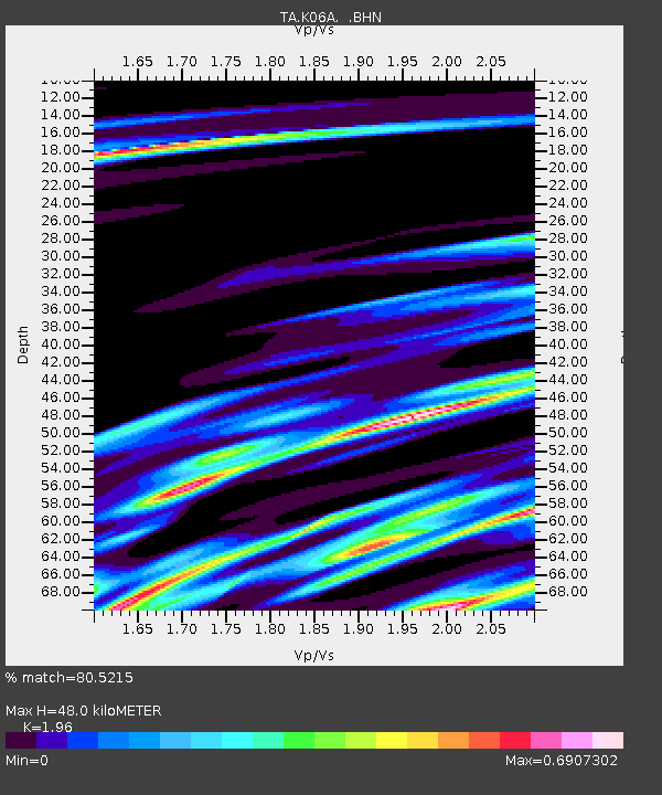
| Estimated Moho Depth: |
48.0 km |
| Estimated Crust Vp/Vs: |
1.96 |
| Assumed Crust Vp: |
6.597 km/s |
| Estimated Crust Vs: |
3.366 km/s |
| Estimated Crust Poisson's Ratio: |
0.32 |
|
| Radial Match: |
80.5215 % |
| Radial Bump: |
264 |
| Transverse Match: |
55.09523 % |
| Transverse Bump: |
275 |
| SOD ConfigId: |
2564 |
| Insert Time: |
2010-03-07 03:15:34.969 +0000 |
| GWidth: |
2.5 |
| Max Bumps: |
400 |
| Tol: |
0.001 |
|

Signal To Noise
| Channel | StoN | STA | LTA |
| TA:K06A: :BHN:20070816T04:10:00.674011Z | 1.4337956 | 2.373366E-7 | 1.655303E-7 |
| TA:K06A: :BHE:20070816T04:10:00.674011Z | 2.8266594 | 4.2150313E-7 | 1.4911706E-7 |
| TA:K06A: :BHZ:20070816T04:10:00.674011Z | 4.766354 | 1.2938834E-6 | 2.714619E-7 |
| Arrivals |
| Ps | 7.5 SECOND |
| PpPs | 20 SECOND |
| PsPs/PpSs | 28 SECOND |


