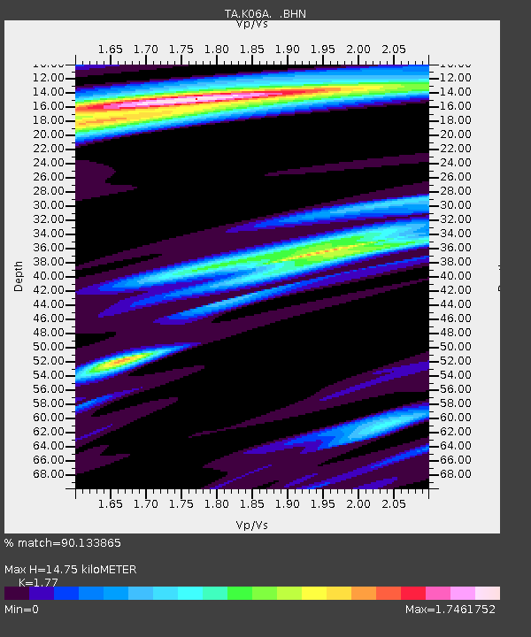
K06A Valley Falls, OR, USA - Earthquake Result Viewer

Earthquake location: Fox Islands, Aleutian Islands
Earthquake latitude/longitude: 52.5/-169.3
Earthquake time(UTC): 2006/05/10 (130) 02:42:51 GMT
Earthquake Depth: 18 km
Earthquake Magnitude: 6.1 MB, 6.2 MS, 6.4 MW, 6.3 MW
Earthquake Catalog/Contributor: WHDF/NEIC
Network: TA USArray Transportable Network (new EarthScope stations)
Station: K06A Valley Falls, OR, USA
Lat/Lon: 42.80 N/120.25 W
Elevation: 1340 m
Distance: 33.8 deg
Az: 86.75 deg
Baz: 304.005 deg
Ray Param: 0.07802029
Estimated Moho Depth: 14.75 km
Estimated Crust Vp/Vs: 1.77
Assumed Crust Vp: 6.597 km/s
Estimated Crust Vs: 3.727 km/s
Estimated Crust Poisson's Ratio: 0.27
Radial Match: 90.133865 %
Radial Bump: 308
Transverse Match: 59.775654 %
Transverse Bump: 400
SOD ConfigId: 2669
Insert Time: 2010-03-07 03:16:52.648 +0000
GWidth: 2.5
Max Bumps: 400
Tol: 0.001

Signal To Noise

ChannelStoNSTALTA
TA:K06A: :BHN:20060510T02:49:01.299012Z0.575537441.8098554E-73.1446353E-7
TA:K06A: :BHE:20060510T02:49:01.299012Z0.762726843.019765E-73.9591697E-7
TA:K06A: :BHZ:20060510T02:49:01.299012Z2.68440133.7312222E-71.3899644E-7
Arrivals
Ps1.9 SECOND
PpPs5.7 SECOND
PsPs/PpSs7.6 SECOND