You are here: Home > Network List > XC00 - Yellowstone Intermountain Seismic Array Stations List
> Station Y12 Y12 > Earthquake Result Viewer
Y12 Y12 - Earthquake Result Viewer
| Earthquake location: |
Tonga Islands |
| Earthquake latitude/longitude: |
-15.9/-173.7 |
| Earthquake time(UTC): |
2000/09/11 (255) 17:17:53 GMT |
| Earthquake Depth: |
115 km |
| Earthquake Magnitude: |
6.0 MB, 6.3 MW, 6.3 MW |
| Earthquake Catalog/Contributor: |
WHDF/NEIC |
|
| Network: |
XC Yellowstone Intermountain Seismic Array |
| Station: |
Y12 Y12 |
| Lat/Lon: |
45.60 N/113.11 W |
| Elevation: |
2051 m |
|
| Distance: |
82.1 deg |
| Az: |
38.131 deg |
| Baz: |
237.817 deg |
| Ray Param: |
0.04689768 |
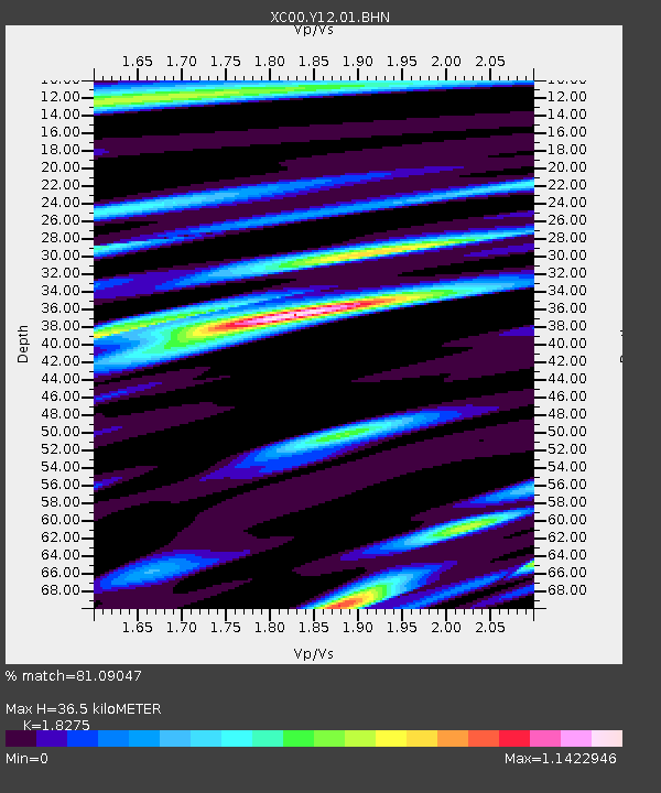
| Estimated Moho Depth: |
36.5 km |
| Estimated Crust Vp/Vs: |
1.83 |
| Assumed Crust Vp: |
6.577 km/s |
| Estimated Crust Vs: |
3.599 km/s |
| Estimated Crust Poisson's Ratio: |
0.29 |
|
| Radial Match: |
81.09047 % |
| Radial Bump: |
400 |
| Transverse Match: |
71.939545 % |
| Transverse Bump: |
400 |
| SOD ConfigId: |
16820 |
| Insert Time: |
2010-02-26 14:59:49.963 +0000 |
| GWidth: |
2.5 |
| Max Bumps: |
400 |
| Tol: |
0.001 |
|

Signal To Noise
| Channel | StoN | STA | LTA |
| XC:Y12:01:BHN:20000911T17:29:29.764014Z | 2.6095219 | 3.945202E-7 | 1.5118486E-7 |
| XC:Y12:01:BHE:20000911T17:29:29.764014Z | 3.9248614 | 3.8382288E-7 | 9.779272E-8 |
| XC:Y12:01:BHZ:20000911T17:29:29.764014Z | 10.210232 | 1.617116E-6 | 1.5838191E-7 |
| Arrivals |
| Ps | 4.7 SECOND |
| PpPs | 15 SECOND |
| PsPs/PpSs | 20 SECOND |


