
Station XC Y12 - Y12
Network: XC00 - Yellowstone Intermountain Seismic Array
Nearby stations (2 deg radius)
| Station | Name | (Lat, Lon) | Start / End | Elevation |
| Y12 | Y12 | (45.60, -113.11) | 2000-07-14 / 2001-12-31 | 2051 m |
| Crust2 Type: | H3,early/mid Proter. shield, Finland, 0.5 km seds. |
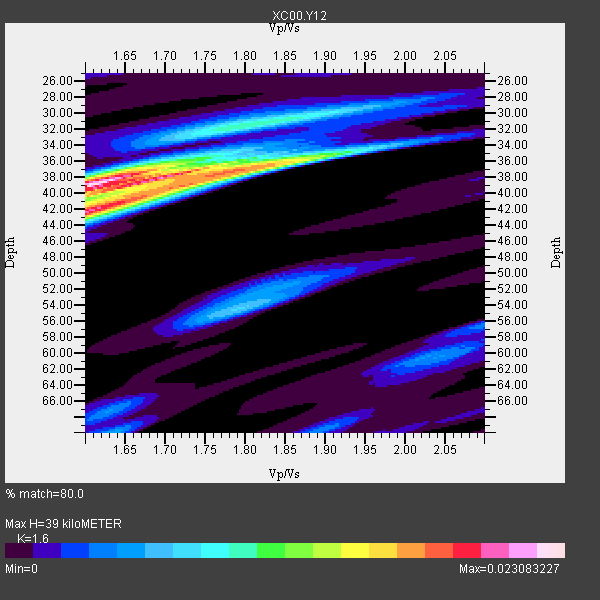
| Thickness Estimate: | 39 km |
| Thickness StdDev: | 2.3 km |
| Vp/Vs Estimate: | 1.60 |
| Vp/Vs StdDev: | 0.08 |
| Vs Estimate: | 4.111 km/s |
| Poisson's Ratio: | 0.18 |
| Peak Value: | 0.02 |
| Assumed Vp: | 6.577 km/s |
| Ps Weight: | 0.33333334 |
| PpPs Weight: | 0.33333334 |
| PsPs Weight: | 0.33333328 |
| Residual Complexity: | 0.725 |
| Nearby stations H: | +- |
| (2.0 deg) Vp/Vs: | +- |
1 with match > 90% ( 11.111111 %) and 9 with match > 80% ( 100.0 %) out of 9.
Download stack as xyz text file.
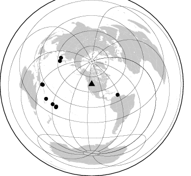
Azimuth Distribution of Events:
Prior Results for this Station
| Study | Thickness | Vp/Vs | Vp | Vs | Poissons Ratio | Extra |
| EARS | 39 km | 1.60 | 6.577 km/s | 4.111 km/s | 0.18 | |
| Crust2.0 | 46 km | 1.78 | 6.577 km/s | 3.701 km/s | 0.27 | H3,early/mid Proter. shield, Finland, 0.5 km seds. |
| Global Maxima | 39 km | 1.60 | 6.577 km/s | 4.111 km/s | 0.18 | amp=0.023083227 |
| Local Maxima 1 | 42 km | 1.63 | 6.577 km/s | 4.041 km/s | 0.20 | amp=0.017306238 |
| Local Maxima 2 | 38 km | 1.76 | 6.577 km/s | 3.732 km/s | 0.26 | amp=0.013561767 |
| Local Maxima 3 | 31 km | 1.82 | 6.577 km/s | 3.624 km/s | 0.28 | amp=0.009198305 |
| Local Maxima 4 | 54 km | 1.79 | 6.577 km/s | 3.669 km/s | 0.27 | amp=0.0070338747 |
| Predicted Arrivals for vertical incidence (zero ray parameter) | |
| Ps | 3.56 SECOND |
| PpPs | 15.42 SECOND |
| PsPs/PpSs | 18.98 SECOND |
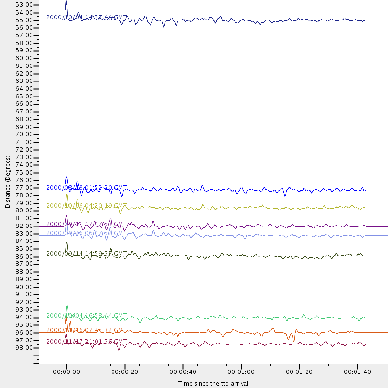
Events Processed for this Station
Download zip of receiver functions as SAC
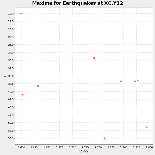
Plot maxima for each earthquake.
Events Used in the Stack
(9 events)| Radial Match | Distance | Baz | FERegion | Time | Lat/Lon | Depth | Magnitude |
| 92.150406 | 83.2 deg | 237.192 deg | Tonga Islands | 2000/09/26 06:17:52 GMT | (-17.2, -173.9) | 56 km | 6.1 MB, 6.1 MS, 6.4 MW, 6.1 ME |
| 88.822685 | 54.9 deg | 112.212 deg | Windward Islands | 2000/10/04 14:37:44 GMT | (11.1, -62.6) | 110 km | 5.6 MB, 5.4 MS, 6.1 MW, 5.9 MD |
| 85.5939 | 96.0 deg | 269.23 deg | New Ireland Region, P.N.G. | 2000/11/16 07:45:32 GMT | (-4.8, 153.2) | 33 km | 6.5 MB, 7.2 MS |
| 82.19729 | 97.5 deg | 269.786 deg | New Britain Region, P.N.G. | 2000/11/17 21:01:56 GMT | (-5.5, 151.8) | 33 km | 6.2 MB, 8.0 MS, 7.6 MW, 6.9 ME |
| 82.1966 | 79.6 deg | 310.563 deg | Western Honshu, Japan | 2000/10/06 04:30:19 GMT | (35.5, 133.1) | 10 km | 5.8 MB, 6.8 MS, 7.0 ME, 6.7 MW |
| 81.91084 | 94.0 deg | 252.193 deg | Vanuatu Islands | 2000/10/04 16:58:44 GMT | (-15.4, 166.9) | 23 km | 6.1 MB, 6.9 MS, 6.8 MW, 6.5 ME |
| 81.76701 | 85.9 deg | 242.778 deg | Fiji Islands | 2000/09/14 14:59:57 GMT | (-15.7, 179.8) | 33 km | 5.7 MB, 6.2 MS, 6.3 MW, 6.2 MW |
| 81.09047 | 82.1 deg | 237.817 deg | Tonga Islands | 2000/09/11 17:17:53 GMT | (-15.9, -173.7) | 115 km | 6.0 MB, 6.3 MW, 6.3 MW |
| 80.03311 | 77.3 deg | 305.886 deg | Near S. Coast Of Honshu, Japan | 2000/08/18 01:52:20 GMT | (34.1, 139.2) | 10 km | 5.6 MB, 5.5 MS, 5.8 MW, 5.7 MW |
Losers
(0 events)| Radial Match | Distance | Baz | FERegion | Time | Lat/Lon | Depth | Magnitude | Reason |
