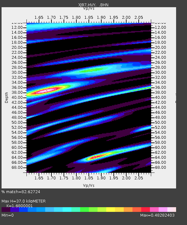
HVY Hills Valley - Earthquake Result Viewer

Earthquake location: Central East Pacific Rise
Earthquake latitude/longitude: -4.4/-105.7
Earthquake time(UTC): 1997/08/15 (227) 07:37:49 GMT
Earthquake Depth: 10 km
Earthquake Magnitude: 5.3 MB, 5.8 MS, 6.2 UNKNOWN, 6.1 MW
Earthquake Catalog/Contributor: WHDF/NEIC
Network: XJ Sierran Paradox
Station: HVY Hills Valley
Lat/Lon: 36.70 N/119.32 W
Elevation: 193 m
Distance: 42.8 deg
Az: 343.827 deg
Baz: 159.782 deg
Ray Param: 0.07295841
Estimated Moho Depth: 37.0 km
Estimated Crust Vp/Vs: 1.68
Assumed Crust Vp: 6.291 km/s
Estimated Crust Vs: 3.745 km/s
Estimated Crust Poisson's Ratio: 0.23
Radial Match: 82.62724 %
Radial Bump: 269
Transverse Match: 67.0904 %
Transverse Bump: 400
SOD ConfigId: 6273
Insert Time: 2010-03-09 20:11:35.094 +0000
GWidth: 2.5
Max Bumps: 400
Tol: 0.001

Signal To Noise

ChannelStoNSTALTA
XJ:HVY: :BHN:19970815T07:45:15.928009Z5.733562.1598511E-73.767033E-8
XJ:HVY: :BHE:19970815T07:45:15.928009Z0.938070543.759457E-84.0076486E-8
XJ:HVY: :BHZ:19970815T07:45:15.928009Z7.41027833.5393654E-74.776292E-8
Arrivals
Ps4.3 SECOND
PpPs15 SECOND
PsPs/PpSs19 SECOND