You are here: Home > Network List > XJ97 - Sierran Paradox Stations List
> Station HVY Hills Valley > Earthquake Result Viewer
HVY Hills Valley - Earthquake Result Viewer
| Earthquake location: |
Tonga Islands |
| Earthquake latitude/longitude: |
-15.2/-175.6 |
| Earthquake time(UTC): |
1997/08/29 (241) 06:54:00 GMT |
| Earthquake Depth: |
33 km |
| Earthquake Magnitude: |
5.6 MB, 6.4 MS, 6.5 UNKNOWN, 6.4 MW |
| Earthquake Catalog/Contributor: |
WHDF/NEIC |
|
| Network: |
XJ Sierran Paradox |
| Station: |
HVY Hills Valley |
| Lat/Lon: |
36.70 N/119.32 W |
| Elevation: |
193 m |
|
| Distance: |
74.0 deg |
| Az: |
44.042 deg |
| Baz: |
236.617 deg |
| Ray Param: |
0.05257431 |
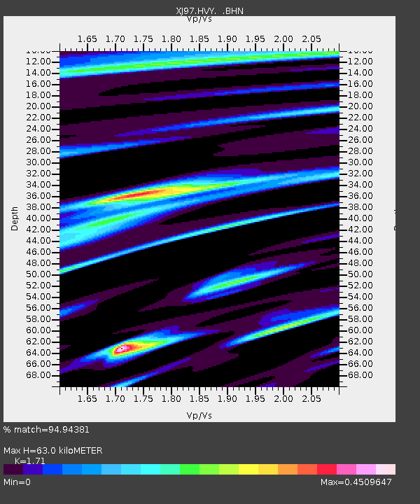
| Estimated Moho Depth: |
63.0 km |
| Estimated Crust Vp/Vs: |
1.71 |
| Assumed Crust Vp: |
6.291 km/s |
| Estimated Crust Vs: |
3.679 km/s |
| Estimated Crust Poisson's Ratio: |
0.24 |
|
| Radial Match: |
94.94381 % |
| Radial Bump: |
233 |
| Transverse Match: |
89.72328 % |
| Transverse Bump: |
400 |
| SOD ConfigId: |
6273 |
| Insert Time: |
2010-03-09 20:11:39.379 +0000 |
| GWidth: |
2.5 |
| Max Bumps: |
400 |
| Tol: |
0.001 |
|

Signal To Noise
| Channel | StoN | STA | LTA |
| XJ:HVY: :BHN:19970829T07:05:01.528003Z | 3.7546568 | 1.1367465E-7 | 3.0275643E-8 |
| XJ:HVY: :BHE:19970829T07:05:01.528003Z | 1.5547209 | 1.3291236E-7 | 8.548953E-8 |
| XJ:HVY: :BHZ:19970829T07:05:01.528003Z | 1.9893572 | 1.2661884E-7 | 6.364812E-8 |
| Arrivals |
| Ps | 7.4 SECOND |
| PpPs | 26 SECOND |
| PsPs/PpSs | 34 SECOND |


