You are here: Home > Network List > XJ97 - Sierran Paradox Stations List
> Station HVY Hills Valley > Earthquake Result Viewer
HVY Hills Valley - Earthquake Result Viewer
| Earthquake location: |
South Of Fiji Islands |
| Earthquake latitude/longitude: |
-26.6/178.3 |
| Earthquake time(UTC): |
1997/09/04 (247) 04:23:37 GMT |
| Earthquake Depth: |
625 km |
| Earthquake Magnitude: |
6.3 MB, 6.8 UNKNOWN, 6.5 ME |
| Earthquake Catalog/Contributor: |
WHDF/NEIC |
|
| Network: |
XJ Sierran Paradox |
| Station: |
HVY Hills Valley |
| Lat/Lon: |
36.70 N/119.32 W |
| Elevation: |
193 m |
|
| Distance: |
86.0 deg |
| Az: |
45.526 deg |
| Baz: |
232.674 deg |
| Ray Param: |
0.04250608 |
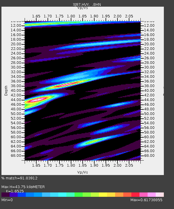
| Estimated Moho Depth: |
43.75 km |
| Estimated Crust Vp/Vs: |
1.65 |
| Assumed Crust Vp: |
6.291 km/s |
| Estimated Crust Vs: |
3.807 km/s |
| Estimated Crust Poisson's Ratio: |
0.21 |
|
| Radial Match: |
91.83912 % |
| Radial Bump: |
400 |
| Transverse Match: |
85.79736 % |
| Transverse Bump: |
400 |
| SOD ConfigId: |
6273 |
| Insert Time: |
2010-03-09 20:11:43.672 +0000 |
| GWidth: |
2.5 |
| Max Bumps: |
400 |
| Tol: |
0.001 |
|

Signal To Noise
| Channel | StoN | STA | LTA |
| XJ:HVY: :BHN:19970904T04:34:41.664001Z | 10.168668 | 4.0261745E-7 | 3.959392E-8 |
| XJ:HVY: :BHE:19970904T04:34:41.664001Z | 14.132075 | 7.393726E-7 | 5.2318754E-8 |
| XJ:HVY: :BHZ:19970904T04:34:41.664001Z | 51.729237 | 2.589429E-6 | 5.0057363E-8 |
| Arrivals |
| Ps | 4.6 SECOND |
| PpPs | 18 SECOND |
| PsPs/PpSs | 23 SECOND |


