You are here: Home > Network List > XJ97 - Sierran Paradox Stations List
> Station HVY Hills Valley > Earthquake Result Viewer
HVY Hills Valley - Earthquake Result Viewer
| Earthquake location: |
Tonga Islands |
| Earthquake latitude/longitude: |
-21.3/-174.4 |
| Earthquake time(UTC): |
1997/09/10 (253) 12:57:07 GMT |
| Earthquake Depth: |
10 km |
| Earthquake Magnitude: |
5.7 MB, 6.1 MS, 6.1 UNKNOWN, 5.9 MW |
| Earthquake Catalog/Contributor: |
WHDF/NEIC |
|
| Network: |
XJ Sierran Paradox |
| Station: |
HVY Hills Valley |
| Lat/Lon: |
36.70 N/119.32 W |
| Elevation: |
193 m |
|
| Distance: |
77.7 deg |
| Az: |
42.41 deg |
| Baz: |
231.472 deg |
| Ray Param: |
0.05016687 |
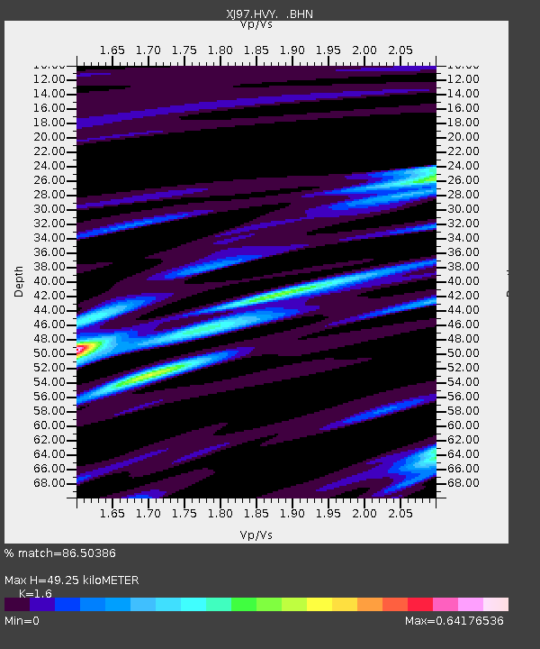
| Estimated Moho Depth: |
49.25 km |
| Estimated Crust Vp/Vs: |
1.60 |
| Assumed Crust Vp: |
6.291 km/s |
| Estimated Crust Vs: |
3.932 km/s |
| Estimated Crust Poisson's Ratio: |
0.18 |
|
| Radial Match: |
86.50386 % |
| Radial Bump: |
338 |
| Transverse Match: |
83.00543 % |
| Transverse Bump: |
400 |
| SOD ConfigId: |
6273 |
| Insert Time: |
2010-03-09 20:11:47.028 +0000 |
| GWidth: |
2.5 |
| Max Bumps: |
400 |
| Tol: |
0.001 |
|

Signal To Noise
| Channel | StoN | STA | LTA |
| XJ:HVY: :BHN:19970910T13:08:32.27002Z | 1.6968874 | 1.0385031E-7 | 6.1200474E-8 |
| XJ:HVY: :BHE:19970910T13:08:32.27002Z | 1.7520517 | 2.2095465E-7 | 1.2611194E-7 |
| XJ:HVY: :BHZ:19970910T13:08:32.27002Z | 3.6182504 | 5.522018E-7 | 1.526157E-7 |
| Arrivals |
| Ps | 4.9 SECOND |
| PpPs | 20 SECOND |
| PsPs/PpSs | 25 SECOND |


