You are here: Home > Network List > XH02 - Western Anatolia Linear Array and Regional Network Stations List
> Station KUL Kula > Earthquake Result Viewer
KUL Kula - Earthquake Result Viewer
| Earthquake location: |
Hindu Kush Region, Afghanistan |
| Earthquake latitude/longitude: |
36.0/70.6 |
| Earthquake time(UTC): |
2003/03/29 (088) 11:46:48 GMT |
| Earthquake Depth: |
114 km |
| Earthquake Magnitude: |
5.9 MB, 5.9 MW, 5.8 MW |
| Earthquake Catalog/Contributor: |
WHDF/NEIC |
|
| Network: |
XH Western Anatolia Linear Array and Regional Network |
| Station: |
KUL Kula |
| Lat/Lon: |
38.54 N/28.63 E |
| Elevation: |
700 m |
|
| Distance: |
33.3 deg |
| Az: |
287.192 deg |
| Baz: |
81.16 deg |
| Ray Param: |
0.07794938 |
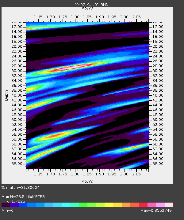
| Estimated Moho Depth: |
28.5 km |
| Estimated Crust Vp/Vs: |
1.78 |
| Assumed Crust Vp: |
6.291 km/s |
| Estimated Crust Vs: |
3.529 km/s |
| Estimated Crust Poisson's Ratio: |
0.27 |
|
| Radial Match: |
81.30004 % |
| Radial Bump: |
400 |
| Transverse Match: |
54.684216 % |
| Transverse Bump: |
400 |
| SOD ConfigId: |
16820 |
| Insert Time: |
2010-03-09 08:25:01.528 +0000 |
| GWidth: |
2.5 |
| Max Bumps: |
400 |
| Tol: |
0.001 |
|

Signal To Noise
| Channel | StoN | STA | LTA |
| XH:KUL:01:BHN:20030329T11:52:45.281013Z | 1.2506735 | 4.3089196E-7 | 3.4452793E-7 |
| XH:KUL:01:BHE:20030329T11:52:45.281013Z | 2.6881483 | 7.5457683E-7 | 2.8070508E-7 |
| XH:KUL:01:BHZ:20030329T11:52:45.281013Z | 10.525945 | 1.1631496E-6 | 1.1050311E-7 |
| Arrivals |
| Ps | 3.8 SECOND |
| PpPs | 12 SECOND |
| PsPs/PpSs | 16 SECOND |


