You are here: Home > Network List > KR - Kyrgyz Digital Network Stations List
> Station MNAS Manas, Kyrgyzstan > Earthquake Result Viewer
MNAS Manas, Kyrgyzstan - Earthquake Result Viewer
| Earthquake location: |
Mindoro, Philippines |
| Earthquake latitude/longitude: |
13.9/120.6 |
| Earthquake time(UTC): |
2015/10/19 (292) 13:50:41 GMT |
| Earthquake Depth: |
106 km |
| Earthquake Magnitude: |
5.8 MWB, 5.9 MWC |
| Earthquake Catalog/Contributor: |
NEIC PDE/NEIC COMCAT |
|
| Network: |
KR Kyrgyz Digital Network |
| Station: |
MNAS Manas, Kyrgyzstan |
| Lat/Lon: |
42.49 N/72.50 E |
| Elevation: |
1465 m |
|
| Distance: |
50.2 deg |
| Az: |
314.235 deg |
| Baz: |
109.806 deg |
| Ray Param: |
0.0678428 |
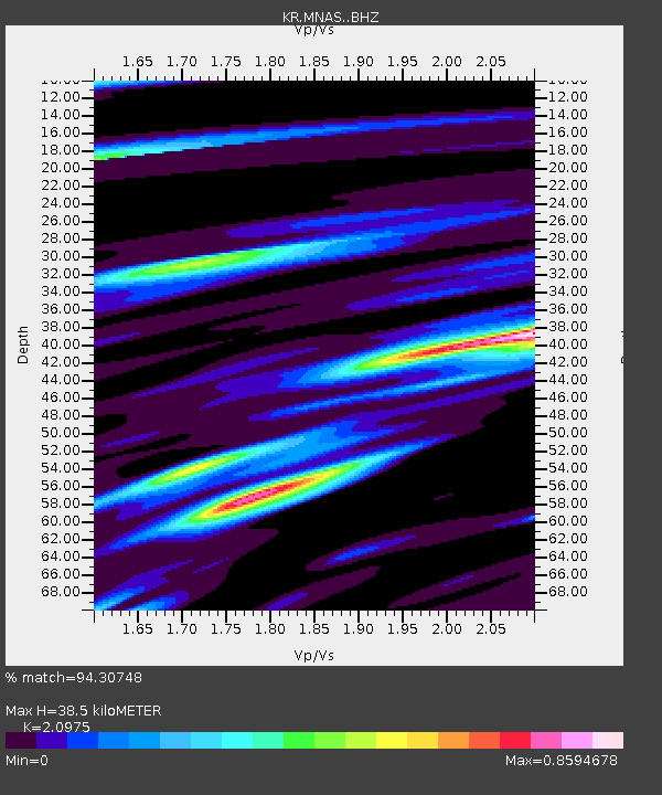
| Estimated Moho Depth: |
38.5 km |
| Estimated Crust Vp/Vs: |
2.10 |
| Assumed Crust Vp: |
6.316 km/s |
| Estimated Crust Vs: |
3.011 km/s |
| Estimated Crust Poisson's Ratio: |
0.35 |
|
| Radial Match: |
94.30748 % |
| Radial Bump: |
352 |
| Transverse Match: |
85.75691 % |
| Transverse Bump: |
400 |
| SOD ConfigId: |
7422571 |
| Insert Time: |
2019-04-21 03:53:59.732 +0000 |
| GWidth: |
2.5 |
| Max Bumps: |
400 |
| Tol: |
0.001 |
|

Signal To Noise
| Channel | StoN | STA | LTA |
| KR:MNAS: :BHZ:20151019T13:58:56.224988Z | 23.04942 | 1.151848E-6 | 4.997297E-8 |
| KR:MNAS: :BHN:20151019T13:58:56.224988Z | 6.054418 | 1.5714087E-7 | 2.5954744E-8 |
| KR:MNAS: :BHE:20151019T13:58:56.224988Z | 16.002207 | 5.099645E-7 | 3.186838E-8 |
| Arrivals |
| Ps | 7.0 SECOND |
| PpPs | 18 SECOND |
| PsPs/PpSs | 25 SECOND |


