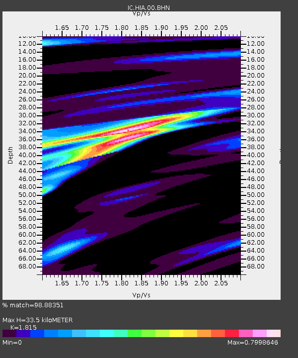
HIA Hailar, Neimenggu Province, China - Earthquake Result Viewer

Earthquake location: New Britain Region, P.N.G.
Earthquake latitude/longitude: -5.5/151.8
Earthquake time(UTC): 2000/11/17 (322) 21:01:56 GMT
Earthquake Depth: 33 km
Earthquake Magnitude: 6.2 MB, 8.0 MS, 7.6 MW, 6.9 ME
Earthquake Catalog/Contributor: WHDF/NEIC
Network: IC New China Digital Seismograph Network
Station: HIA Hailar, Neimenggu Province, China
Lat/Lon: 49.27 N/119.74 E
Elevation: 610 m
Distance: 61.3 deg
Az: 336.65 deg
Baz: 142.965 deg
Ray Param: 0.060934294
Estimated Moho Depth: 33.5 km
Estimated Crust Vp/Vs: 1.82
Assumed Crust Vp: 6.577 km/s
Estimated Crust Vs: 3.624 km/s
Estimated Crust Poisson's Ratio: 0.28
Radial Match: 98.88351 %
Radial Bump: 253
Transverse Match: 84.00607 %
Transverse Bump: 400
SOD ConfigId: 3744
Insert Time: 2010-03-04 22:02:08.093 +0000
GWidth: 2.5
Max Bumps: 400
Tol: 0.001

Signal To Noise

ChannelStoNSTALTA
IC:HIA:00:BHN:20001117T21:11:37.609019Z2.96371943.222575E-71.0873415E-7
IC:HIA:00:BHE:20001117T21:11:37.609019Z2.86232543.2648325E-71.1406223E-7
IC:HIA:00:BHZ:20001117T21:11:37.609995Z4.04409171.0577572E-62.615562E-7
Arrivals
Ps4.4 SECOND
PpPs14 SECOND
PsPs/PpSs18 SECOND