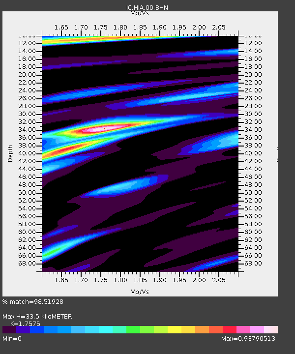
HIA Hailar, Neimenggu Province, China - Earthquake Result Viewer

Earthquake location: New Ireland Region, P.N.G.
Earthquake latitude/longitude: -4.0/152.2
Earthquake time(UTC): 2000/11/16 (321) 04:54:56 GMT
Earthquake Depth: 33 km
Earthquake Magnitude: 6.0 MB, 8.2 MS, 8.0 MW, 8.0 ME
Earthquake Catalog/Contributor: WHDF/NEIC
Network: IC New China Digital Seismograph Network
Station: HIA Hailar, Neimenggu Province, China
Lat/Lon: 49.27 N/119.74 E
Elevation: 610 m
Distance: 60.0 deg
Az: 336.08 deg
Baz: 141.866 deg
Ray Param: 0.06174236
Estimated Moho Depth: 33.5 km
Estimated Crust Vp/Vs: 1.76
Assumed Crust Vp: 6.577 km/s
Estimated Crust Vs: 3.742 km/s
Estimated Crust Poisson's Ratio: 0.26
Radial Match: 98.51928 %
Radial Bump: 229
Transverse Match: 85.0585 %
Transverse Bump: 400
SOD ConfigId: 3744
Insert Time: 2010-03-04 22:02:09.730 +0000
GWidth: 2.5
Max Bumps: 400
Tol: 0.001

Signal To Noise

ChannelStoNSTALTA
IC:HIA:00:BHN:20001116T05:04:29.534006Z0.940878.4171276E-88.946111E-8
IC:HIA:00:BHE:20001116T05:04:29.534006Z0.92266157.1556705E-87.755467E-8
IC:HIA:00:BHZ:20001116T05:04:29.536021Z1.18295482.0381178E-71.7229041E-7
Arrivals
Ps4.1 SECOND
PpPs13 SECOND
PsPs/PpSs17 SECOND